18.9 miles
Distance
3,271 ft
Climb
-3,275 ft
Descent
2,150 ft
High Point
-4 ft
Altitude change
931 ft
Altitude min
935 ft
Altitude start
932 ft
Altitude end
-43.3%
Grade max
38.2%
Grade min
9 miles
Distance climb
8 miles
Distance down
2 miles
Distance flat

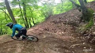
Si parte da Roasio per risalire le vigne fino al punto panoramico che si affaccia sulla diga di Asei, da qui prima discesa per il bellissimo sentiero Pignolo.
Poi una pedalata sino a imboccare l'endurino di Vergnago.
Usciti nel piazzale della chiesa si possono levare le protezioni per pedalare fino ad arrivare al Sentiero M33/M41. Durante questo tragitto potrete fermarvi a pranzare al circolo Arci a San Bononio da Rocco.
Discesi dalla M33/M41 si pedala fino all'area Salti che ci ricondurrà a Roasio dove potrete bere una bella Birra al Musicafè di Tiger.

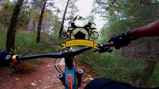
Percorso All-Mountain Enduro da percorrere muniti di casco, protezioni e un minimo di capacità tecnica per i tratti in discesa. Sono presenti le chiken line passaggi più Tecnici.

Detailed Description
Rive rosse 2018 is a 19 mile moderately popular intermediate race route located near Roasio. This mountain bike primary route can be used one direction and has a hard overall physical rating. This route includes 1 trails. This route climbs 3,271 ft with a max elevation of 2,150 ft then descends -3,275 ft.
Local Trail Association
Please consider joining or donating to the local riding association to support trail development & maintenance.
Donate to earn trail karma!

Stats

  • Distance
    19 miles
  • Altitude min
    931 ft
  • Altitude start
    935 ft
  • Altitude end
    932 ft
  • Climb
    3,271 ft
  • Descent
    -3,275 ft
  • Grade max
    -43.3%
  • Grade min
    38.2%
  • Distance climb
    9 miles
  • Distance down
    8 miles
  • Distance flat
    2 miles

6 Reviews & Comments


We hope you've been enjoying Trailforks!

Create a FREE account to view route comments and much more.

Trails in Route

Vergnago4,291 ft

Details

  • Race Course
  • Riding area
  • Primary Activity
    Mountain Bike
  • Other Activities
    • Adaptive Bike
  • Difficulty rating
    Blue
  • Route Type
    Loop
  • Bike type
    AM, Adaptive MTB
  • Direction
    One Direction
  • Physical rating
    Hard
  • Ridelogs
    3
Avg: 4.5 (2 votes)
close
3D
Trail Conditions
  • Unknown
  • Snow Groomed
  • Snow Packed
  • Snow Covered
  • Snow Cover Partial
  • Freeze/thaw Cycle
  • Icy
  • Prevalent Mud
  • Wet
  • Variable
  • Ideal
  • Dry
  • Very Dry
Trail Flow (Ridden Direction)
Trailforks scans users ridelogs to determine the most popular direction each trail is ridden. A good flowing trail network will have most trails flowing in a single direction according to their intension.
The colour categories are based on what percentage of riders are riding a trail in its intended direction.
  • > 96%
  • > 90%
  • > 80%
  • > 70%
  • > 50%
  • < 50%
  • bi-directional trail
  • no data
Trail Last Ridden
Trailforks scans ridelogs to determine the last time a trail was ridden.
  • < 2 days
  • < 1 week
  • < 2 weeks
  • < 1 month
  • < 6 months
  • > 6 months
Trail Ridden Direction
The intended direction a trail should be ridden.
  • Downhill Only
  • Downhill Primary
  • Both Directions
  • Uphill Primary
  • Uphill Only
  • One Direction
Contribute Details
Colors indicate trail is missing specified detail.
  • Description
  • Photos
  • Description & Photos
  • Videos
Trail Popularity ?
Trailforks scans ridelogs to determine which trails are ridden the most in the last 9 months. Trails are compared with nearby trails in the same city region with a possible 25 colour shades. Think of this as a heatmap, more rides = more kinetic energy = warmer colors.
  • most popular
  • popular
  • less popular
  • not popular
ATV/ORV/OHV Filter
Max Vehicle Width
inches
US Cell Coverage
Legend
cell carrier legend

Radar Time
Activity Recordings
Trailforks uses anonymized public activity data. ?
Activity Recordings
Trailforks uses anonymized public activity data. ?
Personal Heatmap
Activity Types
all / none
Options
2
Date range month
Winter Trails
Warning A routing network for winter maps does not exist. Selecting trails using the winter trails layer has been disabled.
Missing Trails
Most Popular
Least Popular
Trails are colored based on popularity. The more popular a trail is, the more red. Less popular trails trend towards green.
Jump Magnitude Heatmap
Heatmap of where riders jump on trails. Zoom in to see individual jumps, click circles to view jump details.
BC Backroad Status

Service Road Atlas is a free to use, community-driven service for viewing and creating reports on the numerous back-country service roads around B.C. and Alberta.

map legend
Slope Aspect
Direction the slope faces
Flat N NE E SE S SW W NW
Trails Deemphasized
Trails are shown in grey.
disable
Only show trails with no bike usage.
Enable
Suggested Layers
Based on selected activity type

    Save the current map location and zoom level as your default home location whenever this page is loaded.

    Save
    Trail transparency
    • Singletrack
    Rive rosse in MTB
    Rive rosse in MTB
    14:42 | 337 | comments: 0 | favs:
    Oct 27, 2018
    Trail Vergnago - Rive Rosse (Biella)
    Trail Vergnago - Rive Rosse (Biella)
    trail: Vergnago
    3:34 | 102 | comments: 0 | favs:
    May 13, 2024

    Recent Trail Reports Along Route

    statustraildateconditiondescription
    Vergnago
    Jun 6, 2026 @ 9:59am (Europe/Rome)
    Jun 6, 2026
    more reports »
    • By FrankyFlowTF Pro & contributors
    • #7029 - 7,810 views

    Hit the Trail

    Open in App

    Get this route on your phone instantly.

    Download Route

    Save to wishlist, Garmin & download.