3.2 miles
Distance
533 ft
Climb
-532 ft
Descent
1,414 ft
High Point
0 ft
Altitude change
1,171 ft
Altitude min
1,227 ft
Altitude start
1,227 ft
Altitude end
-24.4%
Grade max
26.5%
Grade min
1 mile
Distance climb
1 mile
Distance down
2,090 ft
Distance flat

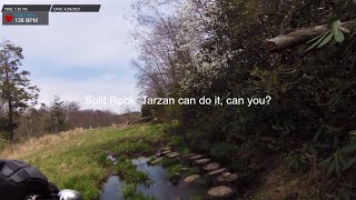
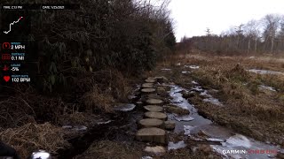
Make the most of limited time and sharpen both your physical and technical ability riding the Split Rock trail out/up & back/down, then ending ascending Cramp Hill.

Be safe and enjoy

Starting location is at the west end of Cherry Ridge Road which is right off of Clinton Road.
FYI - after turning off Clinton Rd onto Cherry Ridge the road turns to all dirt with some large holes, proceed another half mile to the starting area.

Detailed Description
Rock Wrangle is a 3 mile moderately popular expert route located near Vernon New Jersey. This mountain bike primary route can be used both directions and has a hard overall physical rating. This route includes 3 trails. This route climbs 533 ft with a max elevation of 1,414 ft then descends -532 ft.

Trail Issues on Route

  • Significant Issue / Amber: 1 trail (newest: May 13, 2023)
Local Trail Association
Local trail association
Jersey Off Road Bicycle Association (www.jorba.org)
Please consider joining or donating to the local riding association to support trail development & maintenance.
Donate to earn trail karma!

Stats

  • Distance
    3 miles
  • Avg time
    24 min 55 sec
  • Altitude min
    1,171 ft
  • Altitude start
    1,227 ft
  • Altitude end
    1,227 ft
  • Climb
    533 ft
  • Descent
    -532 ft
  • Grade max
    -24.4%
  • Grade min
    26.5%
  • Distance climb
    1 mile
  • Distance down
    1 mile
  • Distance flat
    2,090 ft

1 Review & Comments


We hope you've been enjoying Trailforks!

Create a FREE account to view route comments and much more.

Trails in Route

Split Rock2 miles
Cramp Hill1,749 ft

Details

  • Riding area
  • Primary Activity
    Mountain Bike
  • Other Activities
    • Hike
    • Trail Running
  • Difficulty rating
    Black Diamond
  • Route Type
    Out & Back
  • Bike type
    DH, AM, XC, Fat
  • Direction
    Both Directions
  • Physical rating
    Hard
  • Ridelogs
    1
no votes yet
close
3D
Trail Conditions
  • Unknown
  • Snow Groomed
  • Snow Packed
  • Snow Covered
  • Snow Cover Partial
  • Freeze/thaw Cycle
  • Icy
  • Prevalent Mud
  • Wet
  • Variable
  • Ideal
  • Dry
  • Very Dry
Trail Flow (Ridden Direction)
Trailforks scans users ridelogs to determine the most popular direction each trail is ridden. A good flowing trail network will have most trails flowing in a single direction according to their intension.
The colour categories are based on what percentage of riders are riding a trail in its intended direction.
  • > 96%
  • > 90%
  • > 80%
  • > 70%
  • > 50%
  • < 50%
  • bi-directional trail
  • no data
Trail Last Ridden
Trailforks scans ridelogs to determine the last time a trail was ridden.
  • < 2 days
  • < 1 week
  • < 2 weeks
  • < 1 month
  • < 6 months
  • > 6 months
Trail Ridden Direction
The intended direction a trail should be ridden.
  • Downhill Only
  • Downhill Primary
  • Both Directions
  • Uphill Primary
  • Uphill Only
  • One Direction
Contribute Details
Colors indicate trail is missing specified detail.
  • Description
  • Photos
  • Description & Photos
  • Videos
Trail Popularity ?
Trailforks scans ridelogs to determine which trails are ridden the most in the last 9 months. Trails are compared with nearby trails in the same city region with a possible 25 colour shades. Think of this as a heatmap, more rides = more kinetic energy = warmer colors.
  • most popular
  • popular
  • less popular
  • not popular
ATV/ORV/OHV Filter
Max Vehicle Width
inches
US Cell Coverage
Legend
cell carrier legend

Radar Time
Activity Recordings
Trailforks uses anonymized public activity data. ?
Activity Recordings
Trailforks uses anonymized public activity data. ?
Personal Heatmap
Activity Types
all / none
Options
2
Date range month
Winter Trails
Warning A routing network for winter maps does not exist. Selecting trails using the winter trails layer has been disabled.
Missing Trails
Most Popular
Least Popular
Trails are colored based on popularity. The more popular a trail is, the more red. Less popular trails trend towards green.
Jump Magnitude Heatmap
Heatmap of where riders jump on trails. Zoom in to see individual jumps, click circles to view jump details.
BC Backroad Status

Service Road Atlas is a free to use, community-driven service for viewing and creating reports on the numerous back-country service roads around B.C. and Alberta.

map legend
Slope Aspect
Direction the slope faces
Flat N NE E SE S SW W NW
Trails Deemphasized
Trails are shown in grey.
disable
Only show trails with no bike usage.
Enable
Suggested Layers
Based on selected activity type

    Save the current map location and zoom level as your default home location whenever this page is loaded.

    Save
    Trail transparency
    • Singletrack
    32
    56
    126
    Split Rock Trail 2nd Half Descent 4-28-21
    Split Rock Trail 2nd Half Descent 4-28-21
    trail: Split Rock
    9:23 | 317 | comments: 0 | favs:
    Sep 10, 2021
    Wawayanda 1-25-21 Split Rock Trail - uphill
    Wawayanda 1-25-21 Split Rock Trail - uphill
    trail: Split Rock
    22:48 | 269 | comments: 0 | favs:
    Jan 26, 2021

    Recent Trail Reports Along Route

    statustraildateconditiondescription
    Cramp Hill
    Mar 16, 2025 @ 12:43pm
    Mar 16, 2025
    all clear, some small branches
    Split Rock
    May 13, 2023 @ 6:52am
    May 13, 2023
    more reports »
    • By RobJSinger & contributors
    • #26635 - 483 views

    Hit the Trail

    Open in App

    Get this route on your phone instantly.

    Download Route

    Save to wishlist, Garmin & download.