19.7 miles
Distance
3,925 ft
Climb
-3,904 ft
Descent
3,028 ft
High Point
21 ft
Altitude change
39 ft
Altitude min
39 ft
Altitude start
59 ft
Altitude end
-69.4%
Grade max
45%
Grade min
10 miles
Distance climb
9 miles
Distance down
4,767 ft
Distance flat

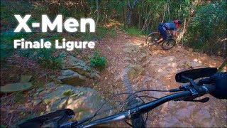
salita da finalborgo fino al din...prima su asflato e poi in nel bosco su comoda e larga strada bianca....una volta in cima si affrontano alcuni dei piu bei sentieri del finalese.....in poche parole dai monti al mare....tra passaggi emozionanti e paesaggi unici....

Detailed Description
Rollecoster e verezzi is a 20 mile popular intermediate route located near Finale Ligure. This mountain bike primary route can be used one direction and has a hard overall physical rating. This route includes 7 trails. This route climbs 3,925 ft with a max elevation of 3,028 ft then descends -3,904 ft.
Local Trail Association
Local trail association
Finale Outdoor Region (www.finaleoutdoor.com)
Please consider joining or donating to the local riding association to support trail development & maintenance.
Donate to earn trail karma!

Stats

  • Distance
    20 miles
  • Avg time
    2 hr 25 min
  • Altitude change
    21 ft
  • Altitude min
    39 ft
  • Altitude start
    39 ft
  • Altitude end
    59 ft
  • Climb
    3,925 ft
  • Descent
    -3,904 ft
  • Grade max
    -69.4%
  • Grade min
    45%
  • Distance climb
    10 miles
  • Distance down
    9 miles
  • Distance flat
    4,767 ft

43 Reviews & Comments


We hope you've been enjoying Trailforks!

Create a FREE account to view route comments and much more.

Trails in Route

Details

  • Riding area
  • Primary Activity
    Mountain Bike
  • Other Activities
    • E-Bike
  • Difficulty rating
    Blue
  • eBike Allowed
  • Bike type
    DH, AM
  • Direction
    One Direction
  • Physical rating
    Hard
  • Ridelogs
    13
Avg: 3 (4 votes)
close
3D
Trail Conditions
  • Unknown
  • Snow Groomed
  • Snow Packed
  • Snow Covered
  • Snow Cover Partial
  • Freeze/thaw Cycle
  • Icy
  • Prevalent Mud
  • Wet
  • Variable
  • Ideal
  • Dry
  • Very Dry
Trail Flow (Ridden Direction)
Trailforks scans users ridelogs to determine the most popular direction each trail is ridden. A good flowing trail network will have most trails flowing in a single direction according to their intension.
The colour categories are based on what percentage of riders are riding a trail in its intended direction.
  • > 96%
  • > 90%
  • > 80%
  • > 70%
  • > 50%
  • < 50%
  • bi-directional trail
  • no data
Trail Last Ridden
Trailforks scans ridelogs to determine the last time a trail was ridden.
  • < 2 days
  • < 1 week
  • < 2 weeks
  • < 1 month
  • < 6 months
  • > 6 months
Trail Ridden Direction
The intended direction a trail should be ridden.
  • Downhill Only
  • Downhill Primary
  • Both Directions
  • Uphill Primary
  • Uphill Only
  • One Direction
Contribute Details
Colors indicate trail is missing specified detail.
  • Description
  • Photos
  • Description & Photos
  • Videos
Trail Popularity ?
Trailforks scans ridelogs to determine which trails are ridden the most in the last 9 months. Trails are compared with nearby trails in the same city region with a possible 25 colour shades. Think of this as a heatmap, more rides = more kinetic energy = warmer colors.
  • most popular
  • popular
  • less popular
  • not popular
ATV/ORV/OHV Filter
Max Vehicle Width
inches
US Cell Coverage
Legend
cell carrier legend

Radar Time
Activity Recordings
Trailforks uses anonymized public activity data. ?
Activity Recordings
Trailforks uses anonymized public activity data. ?
Personal Heatmap
Activity Types
all / none
Options
2
Date range month
Winter Trails
Warning A routing network for winter maps does not exist. Selecting trails using the winter trails layer has been disabled.
Missing Trails
Most Popular
Least Popular
Trails are colored based on popularity. The more popular a trail is, the more red. Less popular trails trend towards green.
Jump Magnitude Heatmap
Heatmap of where riders jump on trails. Zoom in to see individual jumps, click circles to view jump details.
BC Backroad Status

Service Road Atlas is a free to use, community-driven service for viewing and creating reports on the numerous back-country service roads around B.C. and Alberta.

map legend
Slope Aspect
Direction the slope faces
Flat N NE E SE S SW W NW
Trails Deemphasized
Trails are shown in grey.
disable
Only show trails with no bike usage.
Enable
Suggested Layers
Based on selected activity type

    Save the current map location and zoom level as your default home location whenever this page is loaded.

    Save
    Trail transparency
    • Singletrack
    • Unpaved
    95
    164
    130
    129
    X-Men & Orera
    X-Men & Orera
    trail: X-Men
    9:49 | 138 | comments: 0 | favs:
    Nov 9, 2025

    Recent Trail Reports Along Route

    statustraildateconditiondescription
    X-Men
    Jun 14, 2026 @ 10:27pm (Europe/Rome)
    Jun 14, 2026
    Tutto ok
    Access to Verezzi area
    Jun 12, 2026 @ 12:40pm (Europe/Monaco)
    Jun 12, 2026
    Collarina
    Jun 1, 2026 @ 8:25am (Europe/Rome)
    May 31, 2026
    Some rocks here and there but fully rideable. Better with ebike of course.
    Sentiero delle Spine
    May 28, 2026 @ 4:48pm (Europe/Monaco)
    May 28, 2026
    Via per Gorra
    May 17, 2026 @ 9:42am (Europe/Monaco)
    May 17, 2026
    more reports »
    • By Markus1281TF Pro & contributors
    • #25117 - 4,040 views

    Hit the Trail

    Open in App

    Get this route on your phone instantly.

    Download Route

    Save to wishlist, Garmin & download.