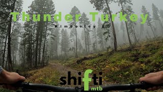
ROUND THE MOUNTAIN - 20KM BIKE
One bike, one rider, one mountain, lots of single track. 2 new 3km purpose built mountain bike single tracks were completed in 2014. Don't miss your chance to ride these amazing new trails.
The 2022 winning time was 1:24, intermediate riders should allow at least 2hrs to complete the 20 km loop. You don't need to be an expert Mountain Biker, though we would like to note that there are some very technical sections, and beginners should be prepared to walk some sections.
Trail Issues on Route
- Minor Issue / Yellow: 2 trails (newest: May 30, 2026)
Route Supporters

Kimberley Trails SocietyBuilder
Kimberley Trails SocietyMaintainer
Kimberley Nature Park SocietyMaintainer
Past Events
Stats
-
Distance14 miles
-
Altitude min3,921 ft
-
Altitude start4,297 ft
-
Altitude end4,298 ft
-
Climb2,081 ft
-
Descent-2,077 ft
-
Grade max-51%
-
Grade min127.3%
-
Distance climb7 miles
-
Distance down6 miles
-
Distance flat4,098 ft
9 Reviews & Comments
We hope you've been enjoying Trailforks!
Create a FREE account to view route comments and much more.
Trails in Route
| 2 miles | |||||
| 617 ft | |||||
| 1 mile | |||||
| 1,388 ft | |||||
| 1 mile | |||||
| 3,842 ft |
Route POI
| Check Point 5 (Mtb Finish) | Checkpoint | |
| Check Point 1 | Checkpoint | |
| Check Point 2 | Checkpoint | |
| Check Point 3 | Checkpoint | |
| Check Point 4 | Checkpoint | |
| Aid Station 1 | Aid Station | |
| Aid Station 3 | Aid Station | |
| Aid Station 2 | Aid Station |
Details
-
Race Course
-
Race DateSaturday June 22, 2024
-
Riding area
-
Primary ActivityMountain Bike
-
Other Activities
- Hike
- Trail Running
-
Difficulty ratingBlue
-
Route TypeLoop
-
eBike Allowed
-
Bike typeAM, XC
-
DirectionOne Direction
-
Physical ratingModerate
- Unknown
- Snow Groomed
- Snow Packed
- Snow Covered
- Snow Cover Partial
- Freeze/thaw Cycle
- Icy
- Prevalent Mud
- Wet
- Variable
- Ideal
- Dry
- Very Dry
The colour categories are based on what percentage of riders are riding a trail in its intended direction.
- > 96%
- > 90%
- > 80%
- > 70%
- > 50%
- < 50%
- bi-directional trail
- no data
- < 2 days
- < 1 week
- < 2 weeks
- < 1 month
- < 6 months
- > 6 months
- Downhill Only
- Downhill Primary
- Both Directions
- Uphill Primary
- Uphill Only
- One Direction
- Description
- Photos
- Description & Photos
- Videos
- most popular
- popular
- less popular
- not popular
Service Road Atlas is a free to use, community-driven service for viewing and creating reports on the numerous back-country service roads around B.C. and Alberta.
Save the current map location and zoom level as your default home location whenever this page is loaded.
Save- Singletrack
- Unpaved
Photos
Recent Trail Reports Along Route
- By pascalgrayphoto & contributors
- #50413 - 4,297 views

