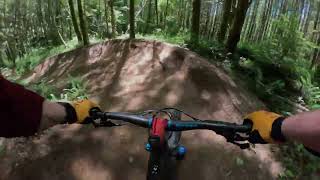
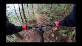
Those whoops and hollers in the woods at Sandy Ridge aren’t Bigfoot but your fellow riders expressing their overwhelming joy. You can see it in their loam-eating grins as they blast back into the trailhead after rallying an unending collection of deep berms, blazing fast straightaways, and chunky rock gardens. See if you can grab the wheel of a local and have them show you the booters and accelerator berms that will help you unlock the ultimate flow. You’re guaranteed to be exhausted but giggling by the time you reach the bottom. Anyone up for another lap?
Route Supporters
Local Trail Association
Northwest Trail Alliance (nw-trail.org)Stats
-
Distance9 miles
-
Avg time1 hr 48 min
-
Altitude min1,045 ft
-
Altitude start1,045 ft
-
Altitude end1,047 ft
-
Climb1,761 ft
-
Descent-1,758 ft
-
Grade max-38.8%
-
Grade min37%
-
Distance climb5 miles
-
Distance down4 miles
-
Distance flat906 ft
32 Reviews & Comments
We hope you've been enjoying Trailforks!
Create a FREE account to view route comments and much more.
Trails in Route
| 4 miles | |||||
| 1,545 ft | |||||
| 4,921 ft | |||||
| 4,967 ft | |||||
| 2 miles |
Details
-
Riding area
-
Primary ActivityMountain Bike
-
Difficulty ratingBlack Diamond
-
Route TypeLoop
-
eBike Allowed
-
Bike typeAM
-
DirectionOne Direction
-
Physical ratingModerate
-
Ridelogs
- Unknown
- Snow Groomed
- Snow Packed
- Snow Covered
- Snow Cover Partial
- Freeze/thaw Cycle
- Icy
- Prevalent Mud
- Wet
- Variable
- Ideal
- Dry
- Very Dry
The colour categories are based on what percentage of riders are riding a trail in its intended direction.
- > 96%
- > 90%
- > 80%
- > 70%
- > 50%
- < 50%
- bi-directional trail
- no data
- < 2 days
- < 1 week
- < 2 weeks
- < 1 month
- < 6 months
- > 6 months
- Downhill Only
- Downhill Primary
- Both Directions
- Uphill Primary
- Uphill Only
- One Direction
- Description
- Photos
- Description & Photos
- Videos
- most popular
- popular
- less popular
- not popular
Service Road Atlas is a free to use, community-driven service for viewing and creating reports on the numerous back-country service roads around B.C. and Alberta.
Save the current map location and zoom level as your default home location whenever this page is loaded.
Save- Singletrack
- Unpaved
Photos
Videos
Recent Trail Reports Along Route
- By gorgechris
OTTA & contributors - #10919 - 5,002 views

