
Open in App
Get this route on your phone instantly.
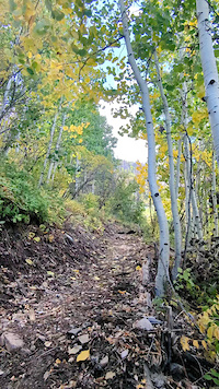
This is a bike skill and fitness heavy route in a big mountain, back country setting. Riders need to come prepared with food, lots of water, tools and a good attitude. Bring a friend. Let someone know what you're up to.
Check individual trail reports before attempting this route. Conditions can be quite variable depending on seasonal maintenance, especially, after winter and after the monsoon. This is a bike skill heavy and high physical fitness route as you climb over 3000ft with a shuttle. Elevation is a factor as most of the route is above 6000ft and up to 10,000 ft. Come prepared with tools, layers, snacks, lots of water.
Shuttle can be run by placing a car at Noon Creek Picnic Area and at the parking area next to the Shannon Campground Road. Route consists of descending climbing the 2.5 mile Heliograph Road, descending Heliograph trail to then Arcadia Trail to Upper Arcadia Camp (seasonally has water). From Upper Arcadia camp head up the Swift Hwy approximately 2.2 miles to Turkey Flat Trail. Ride/hike a bike up Turkey Flat Trail. Then begin descending Ladybug Trail until you get to the lower trail head at Angle Orchard.
From there take the fire road out to the Swift Hwy go left and climb the Swift Hwy approximately 2 miles uphill from where turn onto the Swift Hwy from the Angle Orchard Road to non descript parking pull out at 32.652613, -109.810729. This begins the .75 mile hike a bike to the start of Round the Mountain Trail. Once you top out continue right onto Round the Mountain trail until it comes to a T with Connector Trail. Take a left and head toward the Noon Creek drainageTake this until you get to the creek crossing. Stay right after crossing the rocky creek area and then look for the trail to by pass a boulder area. The trail goes to the left and then heads up to the right out to the drainage. Once out of the drainage stay right/downhill on Noon Creek Trail. Enjoy fast techy trail all the way back down to Noon Creek Picnic area. There will be one turn to the left about 3/4 of the way down Noon Creek Trail. Stay hard left or else you'll end up back at the creek and over in Round the Mountain Campground. You'll finish near a small parking lot and picnic table in the Noon Creek Campground. Congrats You just descended 7300ft!
Want to make these trails better? Email [email protected]
We hope you've been enjoying Trailforks!
Create a FREE account to view route comments and much more.
| 2 miles | |||||
| 4,006 ft | |||||
| 4 miles | |||||
| 2,546 ft | |||||
| 4 miles | |||||
| 2,136 ft | |||||
| 4,012 ft |

Service Road Atlas is a free to use, community-driven service for viewing and creating reports on the numerous back-country service roads around B.C. and Alberta.
Save the current map location and zoom level as your default home location whenever this page is loaded.
Save| status | trail | date | condition | description |
|---|---|---|---|---|
Jun 16, 2026 @ 9:07am (America/Phoenix) 2 days | Trail is clear of down trees and one boulder that was about 3.5 miles down from the top. A small crew of riders helped get those off the trail. Select brush work was done to open up over vegetated areas. Also some removal of loose rocks from the high speed Fern and Burn section. Some corner tuning as well. Arcadia is in decent shape but it's still a big mountain, backcountry trail. | |||
May 24, 2026 @ 7:04pm (America/Phoenix) May 24, 2026 | Trail clear. No downed trees. | |||
May 18, 2026 @ 5:36pm (America/Phoenix) May 18, 2026 | Lower Ladybug is free of down trees as of May 16th 2026. SDMB volunteers removed 3 down trees with hand tools and rerouted about 60 ft of trail located about 1/2 mile down from the Turkey Flat Trail Junction. This new 60 foot section replaces and very sharp corner that was causing erosion due to no grade reversal. The reroute creates a grade reversal to reduce erosion, check speed of downhill traffinc and make for a nicer turning radius. | |||
Dec 29, 2025 @ 8:30pm (America/Phoenix) Dec 29, 2025 | Rode Dec 28th 2025: Trail is feeling a bit scoured from big October rains and full of loose good sized boulders but it's got good elevation lost and rewards those that are willing to ride the rubble. It's occured to SDMB to tune this one up a bit soon as it's lost attention due to upper mtn pursuits. Could be a part of early season work in March. Interested? Email [email protected]. | |||
Dec 29, 2025 @ 8:13pm (America/Phoenix) Dec 29, 2025 | Rode Dec 28th 2025: trail is clear albeit it feeling a bit rustic due to off season lack of use. A couple of snow patches but nothing to worry about. Typical mix of pedal and push to get to the Ladybug descent. If you're thinking about visiting this winter to ride Ladybug be mindful it can easily be snowy from the TF trailhead up to the Ladybug trail jct. This report is relevant to a low snow early winter not the norm. Call the Safford USFS Ranger station for the latest observations. |