14.7 miles
Distance
3,799 ft
Climb
-3,802 ft
Descent
2,003 ft
High Point
-2 ft
Altitude change
341 ft
Altitude min
675 ft
Altitude start
673 ft
Altitude end
-66.2%
Grade max
68.9%
Grade min
7 miles
Distance climb
6 miles
Distance down
1 mile
Distance flat

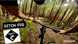
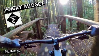
This is a big day. Angry Midget and Ditch Pig are fast and rooty (I personally prefer Ditch Pig if you only want to do one climb). Somewhere Over There is a great trail with some crazy rock slabs that definitely have you second guessing on the first go-around. Poop Alley is a fun, fast, flowy easy trail to end the day. 

Detailed Description
Somewhere Over There is a 15 mile popular intermediate route located near Squamish British Columbia. This mountain bike only route. This route includes 13 trails. This route climbs 3,799 ft with a max elevation of 2,003 ft then descends -3,802 ft.

Trail Issues on Route

  • Minor Issue / Yellow: 3 trails (newest: May 28, 2026)
Local Trail Association
Local trail association
Squamish Off-Road Cycling Association (www.sorca.ca)
Please consider joining or donating to the local riding association to support trail development & maintenance.
Donate to earn trail karma!

Stats

  • Distance
    15 miles
  • Avg time
    3 hr 52 min
  • Altitude change
    -2 ft
  • Altitude min
    341 ft
  • Altitude start
    675 ft
  • Altitude end
    673 ft
  • Climb
    3,799 ft
  • Descent
    -3,802 ft
  • Grade max
    -66.2%
  • Grade min
    68.9%
  • Distance climb
    7 miles
  • Distance down
    6 miles
  • Distance flat
    1 mile

90 Reviews & Comments


We hope you've been enjoying Trailforks!

Create a FREE account to view route comments and much more.

Details

  • Riding area
  • Primary Activity
    Mountain Bike
  • Difficulty rating
    Blue
  • Ridelogs
    2
Avg: 3.65 (3 votes)
close
3D
Trail Conditions
  • Unknown
  • Snow Groomed
  • Snow Packed
  • Snow Covered
  • Snow Cover Partial
  • Freeze/thaw Cycle
  • Icy
  • Prevalent Mud
  • Wet
  • Variable
  • Ideal
  • Dry
  • Very Dry
Trail Flow (Ridden Direction)
Trailforks scans users ridelogs to determine the most popular direction each trail is ridden. A good flowing trail network will have most trails flowing in a single direction according to their intension.
The colour categories are based on what percentage of riders are riding a trail in its intended direction.
  • > 96%
  • > 90%
  • > 80%
  • > 70%
  • > 50%
  • < 50%
  • bi-directional trail
  • no data
Trail Last Ridden
Trailforks scans ridelogs to determine the last time a trail was ridden.
  • < 2 days
  • < 1 week
  • < 2 weeks
  • < 1 month
  • < 6 months
  • > 6 months
Trail Ridden Direction
The intended direction a trail should be ridden.
  • Downhill Only
  • Downhill Primary
  • Both Directions
  • Uphill Primary
  • Uphill Only
  • One Direction
Contribute Details
Colors indicate trail is missing specified detail.
  • Description
  • Photos
  • Description & Photos
  • Videos
Trail Popularity ?
Trailforks scans ridelogs to determine which trails are ridden the most in the last 9 months. Trails are compared with nearby trails in the same city region with a possible 25 colour shades. Think of this as a heatmap, more rides = more kinetic energy = warmer colors.
  • most popular
  • popular
  • less popular
  • not popular
ATV/ORV/OHV Filter
Max Vehicle Width
inches
US Cell Coverage
Legend
cell carrier legend

Radar Time
Activity Recordings
Trailforks uses anonymized public activity data. ?
Activity Recordings
Trailforks uses anonymized public activity data. ?
Personal Heatmap
Activity Types
all / none
Options
2
Date range month
Winter Trails
Warning A routing network for winter maps does not exist. Selecting trails using the winter trails layer has been disabled.
Missing Trails
Most Popular
Least Popular
Trails are colored based on popularity. The more popular a trail is, the more red. Less popular trails trend towards green.
Jump Magnitude Heatmap
Heatmap of where riders jump on trails. Zoom in to see individual jumps, click circles to view jump details.
BC Backroad Status

Service Road Atlas is a free to use, community-driven service for viewing and creating reports on the numerous back-country service roads around B.C. and Alberta.

map legend
Slope Aspect
Direction the slope faces
Flat N NE E SE S SW W NW
Trails Deemphasized
Trails are shown in grey.
disable
Only show trails with no bike usage.
Enable
Suggested Layers
Based on selected activity type

    Save the current map location and zoom level as your default home location whenever this page is loaded.

    Save
    Trail transparency
    • Singletrack
    • Unpaved
    1,248
    465
    1,305
    818
    youtuber Ditch Pig | Single Black trail | Squamish, BC
    Ditch Pig | Single Black trail | Squamish, BC
    3:27 | 74 | comments: 0 | favs:
    Apr 21, 2026
    youtuber ANGRY MIDGET | Black trail | Squamish - University
    ANGRY MIDGET | Black trail | Squamish - University
    trail: Angry M
    3:28 | 228 | comments: 0 | favs:
    Dec 23, 2023

    Recent Trail Reports Along Route

    statustraildateconditiondescription
    Powerhouse Plunge
    Jun 16, 2026 @ 3:29pm (America/Vancouver)
    3 days
    fantastic work...as someone who rode it 25 years ago for TOM..and rarely since, I really appreciate both the new trail bed and the old jank :) . Ridden with a smile and a giggle. Love the Moss Drop. Mostly a hard Blue imo.
    Angry M
    Jun 10, 2026 @ 2:09pm (America/Vancouver)
    Jun 10, 2026
    Climb Trail - Stl'lhalem Sintl'
    Jun 4, 2026 @ 6:02pm (America/Vancouver)
    Jun 4, 2026
    Legacy Climb Trail - Stl'lhalem Sintl'
    Jun 4, 2026 @ 6:02pm (America/Vancouver)
    Jun 4, 2026
    Climb Trail - Stl'lhalem Sintl' (mid)
    Jun 4, 2026 @ 6:02pm (America/Vancouver)
    Jun 4, 2026
    more reports »
    • By twowheeledwandererTF Pro & contributors
    • #13985 - 3,127 views

    Hit the Trail

    Open in App

    Get this route on your phone instantly.

    Download Route

    Save to wishlist, Garmin & download.