3.8 miles
Distance
819 ft
Climb
-857 ft
Descent
914 ft
High Point
-39 ft
Altitude change
349 ft
Altitude min
388 ft
Altitude start
348 ft
Altitude end
-0.2%
Grade
-50.5%
Grade max
48%
Grade min
2 miles
Distance climb
2 miles
Distance down
1,112 ft
Distance flat

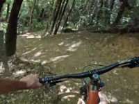
A good size circuit from the carpark. Take the Wetland loop to Directa. Climb Directa to Jungle Gym, and carry onto climbing until Labyrinth. At the top of Labyrinth head down Spoonhill - 491 - and back onto Spoonhill all the way to Nga Tuna. At the bottom of Nga Tuna veer right around the Wetland loop back to Directa. Climb Directa and turn left into Beeline (don't forget to drop of the ramps) and head through Beeline extension to the carpark. Great fun

Detailed Description
Spoonhill Circuit is a 4 mile popular expert route located near Lower Hutt. This mountain bike only route can be used one direction and has a hard overall physical rating. This route includes 8 trails. This route climbs 819 ft with a max elevation of 914 ft then descends -857 ft.

Trail Issues on Route

  • Minor Issue / Yellow: 1 trail (newest: May 9, 2026)
Local Trail Association
Local trail association
Wainuiomata Trail Project (www.wtp.org.nz)
Please consider joining or donating to the local riding association to support trail development & maintenance.
Donate to earn trail karma!

Stats

  • Distance
    4 miles
  • Avg time
    57 min 14 sec
  • Altitude min
    349 ft
  • Altitude start
    388 ft
  • Altitude end
    348 ft
  • Climb
    819 ft
  • Descent
    -857 ft
  • Grade
    -0.2%
  • Grade max
    -50.5%
  • Grade min
    48%
  • Distance climb
    2 miles
  • Distance down
    2 miles
  • Distance flat
    1,112 ft

16 Reviews & Comments


We hope you've been enjoying Trailforks!

Create a FREE account to view route comments and much more.

Trails in Route

Wetland Loop3,770 ft
Directa2,851 ft
Labyrinth374 ft
Spoonhill5,141 ft
4911,476 ft
Nga Tuna1,079 ft
Beeline1,900 ft

Details

  • Riding area
  • Primary Activity
    Mountain Bike
  • Difficulty rating
    Black Diamond
  • Route Type
    Loop
  • Bike type
    DH, AM
  • Direction
    One Direction
  • Physical rating
    Hard
  • Ridelogs
    109
no votes yet
close
3D
Trail Conditions
  • Unknown
  • Snow Groomed
  • Snow Packed
  • Snow Covered
  • Snow Cover Partial
  • Freeze/thaw Cycle
  • Icy
  • Prevalent Mud
  • Wet
  • Variable
  • Ideal
  • Dry
  • Very Dry
Trail Flow (Ridden Direction)
Trailforks scans users ridelogs to determine the most popular direction each trail is ridden. A good flowing trail network will have most trails flowing in a single direction according to their intension.
The colour categories are based on what percentage of riders are riding a trail in its intended direction.
  • > 96%
  • > 90%
  • > 80%
  • > 70%
  • > 50%
  • < 50%
  • bi-directional trail
  • no data
Trail Last Ridden
Trailforks scans ridelogs to determine the last time a trail was ridden.
  • < 2 days
  • < 1 week
  • < 2 weeks
  • < 1 month
  • < 6 months
  • > 6 months
Trail Ridden Direction
The intended direction a trail should be ridden.
  • Downhill Only
  • Downhill Primary
  • Both Directions
  • Uphill Primary
  • Uphill Only
  • One Direction
Contribute Details
Colors indicate trail is missing specified detail.
  • Description
  • Photos
  • Description & Photos
  • Videos
Trail Popularity ?
Trailforks scans ridelogs to determine which trails are ridden the most in the last 9 months. Trails are compared with nearby trails in the same city region with a possible 25 colour shades. Think of this as a heatmap, more rides = more kinetic energy = warmer colors.
  • most popular
  • popular
  • less popular
  • not popular
ATV/ORV/OHV Filter
Max Vehicle Width
inches
US Cell Coverage
Legend
cell carrier legend

Radar Time
Activity Recordings
Trailforks uses anonymized public activity data. ?
Activity Recordings
Trailforks uses anonymized public activity data. ?
Personal Heatmap
Activity Types
all / none
Options
2
Date range month
Winter Trails
Warning A routing network for winter maps does not exist. Selecting trails using the winter trails layer has been disabled.
Missing Trails
Most Popular
Least Popular
Trails are colored based on popularity. The more popular a trail is, the more red. Less popular trails trend towards green.
Jump Magnitude Heatmap
Heatmap of where riders jump on trails. Zoom in to see individual jumps, click circles to view jump details.
BC Backroad Status

Service Road Atlas is a free to use, community-driven service for viewing and creating reports on the numerous back-country service roads around B.C. and Alberta.

map legend
Slope Aspect
Direction the slope faces
Flat N NE E SE S SW W NW
Trails Deemphasized
Trails are shown in grey.
disable
Only show trails with no bike usage.
Enable
Suggested Layers
Based on selected activity type

    Save the current map location and zoom level as your default home location whenever this page is loaded.

    Save
    Trail transparency
    • Singletrack
    • Unpaved
    70
    72
    213
    183
    First ever GAP JUMP MTB! Was not ready for that...
    First ever GAP JUMP MTB! Was not ready for that...
    trail: Beeline
    5:30 | 196 | comments: 0 | favs:
    Mar 14, 2022

    Recent Trail Reports Along Route

    statustraildateconditiondescription
    Directa
    May 10, 2026 @ 8:42am (Pacific/Auckland)
    May 9, 2026
    Small tree down.
    Beeline
    Apr 5, 2026 @ 6:36am (Pacific/Auckland)
    Apr 4, 2026
    Labyrinth
    Feb 26, 2026 @ 11:10am (Pacific/Auckland)
    Feb 25, 2026
    Work on Labyrinth is mainly finished and it is open to ride! Enjoy! Please stay off for a couple days after wet weather until it is dry. reporter
    Wetland Loop
    Jan 3, 2026 @ 7:19pm (Pacific/Auckland)
    Jan 2, 2026
    Spoonhill
    Dec 20, 2025 @ 8:27pm (Pacific/Auckland)
    Dec 19, 2025
    Great if you like super deep, clay ruts and chutes in Top section, more expert for sure. Avoid and take 491
    more reports »
    • By LordRobsonTF Pro & contributors
    • #877 - 2,084 views

    Hit the Trail

    Open in App

    Get this route on your phone instantly.

    Download Route

    Save to wishlist, Garmin & download.