4.8 miles
Distance
198 ft
Climb
-190 ft
Descent
1,205 ft
High Point
6 ft
Altitude change
1,116 ft
Altitude min
1,116 ft
Altitude start
1,122 ft
Altitude end
-10.7%
Grade max
19.1%
Grade min
2 miles
Distance climb
1 mile
Distance down
2 miles
Distance flat

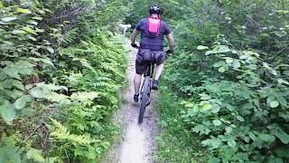
This is the Preferred route most riders take when riding the trails on Suicide Hilll in Sandilands

Detailed Description
Suicide Hill loop is a 5 mile less popular intermediate route located near Steinbach Manitoba. This mountain bike only route. This route includes 19 trails. This route climbs 198 ft with a max elevation of 1,205 ft then descends -190 ft.

Trail Issues on Route

  • Minor Issue / Yellow: 5 trails (newest: May 7, 2024)
Local Trail Association
Please consider joining or donating to the local riding association to support trail development & maintenance.

Stats

  • Distance
    5 miles
  • Avg time
    52 min 53 sec
  • Altitude change
    6 ft
  • Altitude min
    1,116 ft
  • Altitude start
    1,116 ft
  • Altitude end
    1,122 ft
  • Climb
    198 ft
  • Descent
    -190 ft
  • Grade max
    -10.7%
  • Grade min
    19.1%
  • Distance climb
    2 miles
  • Distance down
    1 mile
  • Distance flat
    2 miles

1 Review & Comments


We hope you've been enjoying Trailforks!

Create a FREE account to view route comments and much more.

Trails in Route

Details

Avg: 1 (1 votes)
close
3D
Trail Conditions
  • Unknown
  • Snow Groomed
  • Snow Packed
  • Snow Covered
  • Snow Cover Partial
  • Freeze/thaw Cycle
  • Icy
  • Prevalent Mud
  • Wet
  • Variable
  • Ideal
  • Dry
  • Very Dry
Trail Flow (Ridden Direction)
Trailforks scans users ridelogs to determine the most popular direction each trail is ridden. A good flowing trail network will have most trails flowing in a single direction according to their intension.
The colour categories are based on what percentage of riders are riding a trail in its intended direction.
  • > 96%
  • > 90%
  • > 80%
  • > 70%
  • > 50%
  • < 50%
  • bi-directional trail
  • no data
Trail Last Ridden
Trailforks scans ridelogs to determine the last time a trail was ridden.
  • < 2 days
  • < 1 week
  • < 2 weeks
  • < 1 month
  • < 6 months
  • > 6 months
Trail Ridden Direction
The intended direction a trail should be ridden.
  • Downhill Only
  • Downhill Primary
  • Both Directions
  • Uphill Primary
  • Uphill Only
  • One Direction
Contribute Details
Colors indicate trail is missing specified detail.
  • Description
  • Photos
  • Description & Photos
  • Videos
Trail Popularity ?
Trailforks scans ridelogs to determine which trails are ridden the most in the last 9 months. Trails are compared with nearby trails in the same city region with a possible 25 colour shades. Think of this as a heatmap, more rides = more kinetic energy = warmer colors.
  • most popular
  • popular
  • less popular
  • not popular
ATV/ORV/OHV Filter
Max Vehicle Width
inches
US Cell Coverage
Legend
cell carrier legend

Radar Time
Activity Recordings
Trailforks uses anonymized public activity data. ?
Activity Recordings
Trailforks uses anonymized public activity data. ?
Personal Heatmap
Activity Types
all / none
Options
2
Date range month
Winter Trails
Warning A routing network for winter maps does not exist. Selecting trails using the winter trails layer has been disabled.
Missing Trails
Most Popular
Least Popular
Trails are colored based on popularity. The more popular a trail is, the more red. Less popular trails trend towards green.
Jump Magnitude Heatmap
Heatmap of where riders jump on trails. Zoom in to see individual jumps, click circles to view jump details.
BC Backroad Status

Service Road Atlas is a free to use, community-driven service for viewing and creating reports on the numerous back-country service roads around B.C. and Alberta.

map legend
Slope Aspect
Direction the slope faces
Flat N NE E SE S SW W NW
Trails Deemphasized
Trails are shown in grey.
disable
Only show trails with no bike usage.
Enable
Suggested Layers
Based on selected activity type

    Save the current map location and zoom level as your default home location whenever this page is loaded.

    Save
    Trail transparency
    • Singletrack
    • Unpaved
    330
    323
    323
    300
    Sandilands XC June 2022
    Sandilands XC June 2022
    39:40 | 266 | comments: 0 | favs:
    Jul 24, 2022

    Recent Trail Reports Along Route

    statustraildateconditiondescription
    Bobsled
    May 7, 2024 @ 11:43am
    May 7, 2024
    All deadfall has been cleared as of May. 7, 2024. Trail network has some encroaching brush/eye pokers, but as it's still Spring, it's very manageable. Some descents/climbs suffer from ruts by dirt bikes.
    Limp Pine
    May 7, 2024 @ 11:43am
    May 7, 2024
    All deadfall has been cleared as of May. 7, 2024. Trail network has some encroaching brush/eye pokers, but as it's still Spring, it's very manageable. Some descents/climbs suffer from ruts by dirt bikes.
    Bear Country
    May 7, 2024 @ 11:43am
    May 7, 2024
    All deadfall has been cleared as of May. 7, 2024. Trail network has some encroaching brush/eye pokers, but as it's still Spring, it's very manageable. Some descents/climbs suffer from ruts by dirt bikes.
    Ridgeline
    May 7, 2024 @ 11:43am
    May 7, 2024
    All deadfall has been cleared as of May. 7, 2024. Trail network has some encroaching brush/eye pokers, but as it's still Spring, it's very manageable. Some descents/climbs suffer from ruts by dirt bikes.
    Roller Coaster
    May 7, 2024 @ 11:43am
    May 7, 2024
    All deadfall has been cleared as of May. 7, 2024. Trail network has some encroaching brush/eye pokers, but as it's still Spring, it's very manageable. Some descents/climbs suffer from ruts by dirt bikes.
    more reports »
    • By Singletrack-minded & contributors
    • #8382 - 3,973 views

    Hit the Trail

    Open in App

    Get this route on your phone instantly.

    Download Route

    Save to wishlist, Garmin & download.