
Open in App
Get this route on your phone instantly.
Start at Parking Lot 8 - Maligne Canyon 6th Bridge
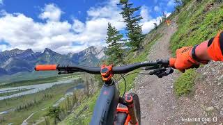
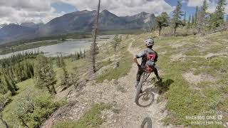
The Overlander starts out with flowy single track through the forest and crosses several drainages and interesting rock features before hitting a meadow and the Moberly Homestead near the halfway point. For an easier day, take a breather at the homestead and enjoy the view before heading back to 6th bridge the Moberlander. After passing the meadow the trail gets more technical with some steep climbs, scree side hills, technical rock features, and more fast single track through the forest. The trail ends at 12 Mile Bridge, enjoy the view for a bit before heading back to 6th bridge.
To lengthen this ride start in town taking Trail 13 and Trail 7.
To shorten this ride do a shuttle and ride one way, in which case it is best to end at 6th Bridge
We hope you've been enjoying Trailforks!
Create a FREE account to view route comments and much more.
| 4 miles | |||||
| 10 miles |

Service Road Atlas is a free to use, community-driven service for viewing and creating reports on the numerous back-country service roads around B.C. and Alberta.
Save the current map location and zoom level as your default home location whenever this page is loaded.
Save