12.5 miles
Distance
2,048 ft
Climb
-2,996 ft
Descent
1 mile
High Point
-948 ft
Altitude change
3,071 ft
Altitude min
4,019 ft
Altitude start
3,071 ft
Altitude end
-1.4%
Grade
-89.6%
Grade max
46%
Grade min
5 miles
Distance climb
7 miles
Distance down
961 ft
Distance flat

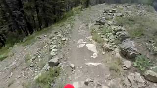
This is one of the better ways to ride Tronsen Ridge. Leaving a vehicle at the bottom of the 5 mile road and shuttling up to FS 7240. Tronsen Meadow trail is pretty steep with a few good hike a bike sections. Once you are up the Tronsen Ridge trail is spectacular.

Detailed Description
Tronsen Ridge is a 12 mile moderately popular expert route located near Wenatchee Washington. This mountain bike only route can be used one direction and has a hard overall physical rating. This route includes 8 trails. This route climbs 2,048 ft with a max elevation of 5,803 ft then descends -2,996 ft.

Trail Issues on Route

  • Significant Issue / Amber: 3 trails (newest: Jun 6, 2026)
Local Trail Association
Local trail association
Chelan-Douglas Land Trust (www.cdlandtrust.org)
Please consider joining or donating to the local riding association to support trail development & maintenance.
Donate to earn trail karma!

Stats

  • Distance
    12 miles
  • Avg time
    4 hr 17 min
  • Altitude change
    -948 ft
  • Altitude min
    3,071 ft
  • Altitude start
    4,019 ft
  • Altitude end
    3,071 ft
  • Climb
    2,048 ft
  • Descent
    -2,996 ft
  • Grade
    -1.4%
  • Grade max
    -89.6%
  • Grade min
    46%
  • Distance climb
    5 miles
  • Distance down
    7 miles
  • Distance flat
    961 ft

9 Reviews & Comments


We hope you've been enjoying Trailforks!

Create a FREE account to view route comments and much more.

Details

  • Riding area
  • Primary Activity
    Mountain Bike
  • Difficulty rating
    Black Diamond
  • Route Type
    Point to Point
  • eBike Allowed
  • Bike type
    AM
  • Direction
    One Direction
  • Physical rating
    Hard
Avg: 3 (1 votes)
close
3D
Trail Conditions
  • Unknown
  • Snow Groomed
  • Snow Packed
  • Snow Covered
  • Snow Cover Partial
  • Freeze/thaw Cycle
  • Icy
  • Prevalent Mud
  • Wet
  • Variable
  • Ideal
  • Dry
  • Very Dry
Trail Flow (Ridden Direction)
Trailforks scans users ridelogs to determine the most popular direction each trail is ridden. A good flowing trail network will have most trails flowing in a single direction according to their intension.
The colour categories are based on what percentage of riders are riding a trail in its intended direction.
  • > 96%
  • > 90%
  • > 80%
  • > 70%
  • > 50%
  • < 50%
  • bi-directional trail
  • no data
Trail Last Ridden
Trailforks scans ridelogs to determine the last time a trail was ridden.
  • < 2 days
  • < 1 week
  • < 2 weeks
  • < 1 month
  • < 6 months
  • > 6 months
Trail Ridden Direction
The intended direction a trail should be ridden.
  • Downhill Only
  • Downhill Primary
  • Both Directions
  • Uphill Primary
  • Uphill Only
  • One Direction
Contribute Details
Colors indicate trail is missing specified detail.
  • Description
  • Photos
  • Description & Photos
  • Videos
Trail Popularity ?
Trailforks scans ridelogs to determine which trails are ridden the most in the last 9 months. Trails are compared with nearby trails in the same city region with a possible 25 colour shades. Think of this as a heatmap, more rides = more kinetic energy = warmer colors.
  • most popular
  • popular
  • less popular
  • not popular
ATV/ORV/OHV Filter
Max Vehicle Width
inches
US Cell Coverage
Legend
cell carrier legend

Radar Time
Activity Recordings
Trailforks uses anonymized public activity data. ?
Activity Recordings
Trailforks uses anonymized public activity data. ?
Personal Heatmap
Activity Types
all / none
Options
2
Date range month
–
Winter Trails
Warning A routing network for winter maps does not exist. Selecting trails using the winter trails layer has been disabled.
Missing Trails
Most Popular
Least Popular
Trails are colored based on popularity. The more popular a trail is, the more red. Less popular trails trend towards green.
Jump Magnitude Heatmap
Heatmap of where riders jump on trails. Zoom in to see individual jumps, click circles to view jump details.
BC Backroad Status

Service Road Atlas is a free to use, community-driven service for viewing and creating reports on the numerous back-country service roads around B.C. and Alberta.

map legend
Slope Aspect
Direction the slope faces
Flat N NE E SE S SW W NW
Trails Deemphasized
Trails are shown in grey.
disable
Only show trails with no bike usage.
Enable
Suggested Layers
Based on selected activity type

    Save the current map location and zoom level as your default home location whenever this page is loaded.

    Save
    Trail transparency
    • Singletrack
    • Unpaved
    199
    182
    662
    828
    Cliffside dirtbike singletrack to die for!
    Cliffside dirtbike singletrack to die for!
    10:56 | 144 | comments: 0 | favs:
    Jan 4, 2025
    Tronsen Ridge trail #1204
    Tronsen Ridge trail #1204
    10:38 | 99 | comments: 0 | favs:
    Jan 4, 2025

    Recent Trail Reports Along Route

    statustraildateconditiondescription
    Mount Lillian Trail #1601
    Jun 6, 2026 @ 5:59pm (America/Los_Angeles)
    Jun 6, 2026
    Only hiked one mile up from Tronsen Meadow and it’s covered with blowdowns
    Tronsen Meadow Trail #1205
    Jun 6, 2026 @ 5:58pm (America/Los_Angeles)
    Jun 6, 2026
    The first mile has been cleared but endless blowdowns and at least one big uprooted tree in the second mile
    Tronsen Ridge
    May 17, 2026 @ 8:12pm (America/Los_Angeles)
    May 17, 2026
    We went up about a mile from Five mile road. Cleared a few blowdowns but then hit what seemed like a very long stretch of downed trees so we turned around
    FS Road 7240
    Aug 8, 2024 @ 1:31am
    Aug 8, 2024
    Fine uphill
    Five Mile Road (FS 7224)
    Jul 5, 2022 @ 11:46am
    Jul 5, 2022
    more reports »
    • By alextrails9TF Pro COTA & contributors
    • #9585 - 2,308 views

    Hit the Trail

    Open in App

    Get this route on your phone instantly.

    Download Route

    Save to wishlist, Garmin & download.