17.4 miles
Distance
1,781 ft
Climb
-1,760 ft
Descent
1 mile
High Point
23 ft
Altitude change
5,621 ft
Altitude min
5,851 ft
Altitude start
5,873 ft
Altitude end
-30.4%
Grade max
33.8%
Grade min
8 miles
Distance climb
7 miles
Distance down
3 miles
Distance flat

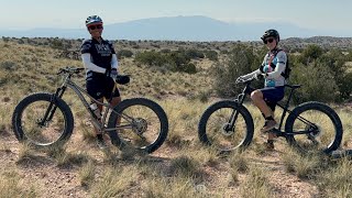
Medium length ride in Mariposa. These rides are not easy. Be self contained and have all your gear and water. Be ready to solve any mechanical issues. You will be in the middle of nowhere with very very limited access if anything goes wrong.

Detailed Description
Twisted Tree is a 17 mile popular intermediate route located near Rio Rancho New Mexico. This mountain bike only route can be used one direction and has a hard overall physical rating. This route includes 11 trails. This route climbs 1,781 ft with a max elevation of 6,239 ft then descends -1,760 ft.
Local Trail Association
Local trail association
Mariposa Fat Bike Society (www.facebook.com)
Please consider joining or donating to the local riding association to support trail development & maintenance.
Donate to earn trail karma!

Stats

  • Distance
    17 miles
  • Avg time
    3 hr 10 min
  • Altitude change
    23 ft
  • Altitude min
    5,621 ft
  • Altitude start
    5,851 ft
  • Altitude end
    5,873 ft
  • Climb
    1,781 ft
  • Descent
    -1,760 ft
  • Grade max
    -30.4%
  • Grade min
    33.8%
  • Distance climb
    8 miles
  • Distance down
    7 miles
  • Distance flat
    3 miles

6 Reviews & Comments


We hope you've been enjoying Trailforks!

Create a FREE account to view route comments and much more.

Details

  • Riding area
  • Primary Activity
    Mountain Bike
  • Difficulty rating
    Blue
  • Bike type
    Fat
  • Direction
    One Direction
  • Physical rating
    Hard
Avg: 5 (1 votes)
close
3D
Trail Conditions
  • Unknown
  • Snow Groomed
  • Snow Packed
  • Snow Covered
  • Snow Cover Partial
  • Freeze/thaw Cycle
  • Icy
  • Prevalent Mud
  • Wet
  • Variable
  • Ideal
  • Dry
  • Very Dry
Trail Flow (Ridden Direction)
Trailforks scans users ridelogs to determine the most popular direction each trail is ridden. A good flowing trail network will have most trails flowing in a single direction according to their intension.
The colour categories are based on what percentage of riders are riding a trail in its intended direction.
  • > 96%
  • > 90%
  • > 80%
  • > 70%
  • > 50%
  • < 50%
  • bi-directional trail
  • no data
Trail Last Ridden
Trailforks scans ridelogs to determine the last time a trail was ridden.
  • < 2 days
  • < 1 week
  • < 2 weeks
  • < 1 month
  • < 6 months
  • > 6 months
Trail Ridden Direction
The intended direction a trail should be ridden.
  • Downhill Only
  • Downhill Primary
  • Both Directions
  • Uphill Primary
  • Uphill Only
  • One Direction
Contribute Details
Colors indicate trail is missing specified detail.
  • Description
  • Photos
  • Description & Photos
  • Videos
Trail Popularity ?
Trailforks scans ridelogs to determine which trails are ridden the most in the last 9 months. Trails are compared with nearby trails in the same city region with a possible 25 colour shades. Think of this as a heatmap, more rides = more kinetic energy = warmer colors.
  • most popular
  • popular
  • less popular
  • not popular
ATV/ORV/OHV Filter
Max Vehicle Width
inches
US Cell Coverage
Legend
cell carrier legend

Radar Time
Activity Recordings
Trailforks uses anonymized public activity data. ?
Activity Recordings
Trailforks uses anonymized public activity data. ?
Personal Heatmap
Activity Types
all / none
Options
2
Date range month
Winter Trails
Warning A routing network for winter maps does not exist. Selecting trails using the winter trails layer has been disabled.
Missing Trails
Most Popular
Least Popular
Trails are colored based on popularity. The more popular a trail is, the more red. Less popular trails trend towards green.
Jump Magnitude Heatmap
Heatmap of where riders jump on trails. Zoom in to see individual jumps, click circles to view jump details.
BC Backroad Status

Service Road Atlas is a free to use, community-driven service for viewing and creating reports on the numerous back-country service roads around B.C. and Alberta.

map legend
Slope Aspect
Direction the slope faces
Flat N NE E SE S SW W NW
Trails Deemphasized
Trails are shown in grey.
disable
Only show trails with no bike usage.
Enable
Suggested Layers
Based on selected activity type

    Save the current map location and zoom level as your default home location whenever this page is loaded.

    Save
    Trail transparency
    • Singletrack
    5
    7
    3
    5
    New Mexico Monsoon
    New Mexico Monsoon
    2:58 | 43 | comments: 0 | favs:
    Aug 9, 2025
    Phat Fun In The High Desert of NM
    Phat Fun In The High Desert of NM
    9:07 | 93 | comments: 0 | favs:
    Jun 28, 2024

    Recent Trail Reports Along Route

    statustraildateconditiondescription
    Lower Reservoir
    Jul 1, 2026 @ 5:53pm (America/Ciudad_Juarez)
    1 day
    Middle Reservoir
    Jun 27, 2026 @ 7:45am (America/Ciudad_Juarez)
    Jun 27, 2026
    Jack Rabbit Ridge
    Jun 27, 2026 @ 7:45am (America/Ciudad_Juarez)
    Jun 27, 2026
    Rattlesnake Rim
    Jun 12, 2026 @ 8:55am (America/Ciudad_Juarez)
    Jun 12, 2026
    Plank Alley
    Jun 12, 2026 @ 8:55am (America/Ciudad_Juarez)
    Jun 12, 2026
    more reports »
    • By TerraFormerTF Pro MFBS & contributors
    • #7872 - 2,045 views

    Hit the Trail

    Open in App

    Get this route on your phone instantly.

    Download Route

    Save to wishlist, Garmin & download.