18.0 miles
Distance
1,634 ft
Climb
-1,632 ft
Descent
1,145 ft
High Point
0 ft
Altitude change
584 ft
Altitude min
590 ft
Altitude start
591 ft
Altitude end
-33.4%
Grade max
22.5%
Grade min
8 miles
Distance climb
8 miles
Distance down
2 miles
Distance flat

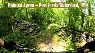
Route covers a good chunk of the park with many black diamond trails along the way.

Be safe and enjoy

source: Rob Singer
Detailed Description
Uncharted Waters is a 18 mile popular expert route located near Port Jervis New York. This mountain bike primary route can be used both directions and has a hard overall physical rating. This route includes 9 trails. This route climbs 1,634 ft with a max elevation of 1,145 ft then descends -1,632 ft.

Trail Issues on Route

  • Minor Issue / Yellow: 1 trail (newest: Nov 29, 2025)
Local Trail Association
Please consider joining or donating to the local riding association to support trail development & maintenance.
Donate to earn trail karma!

Stats

  • Distance
    18 miles
  • Avg time
    5 hr 26 min
  • Altitude min
    584 ft
  • Altitude start
    590 ft
  • Altitude end
    591 ft
  • Climb
    1,634 ft
  • Descent
    -1,632 ft
  • Grade max
    -33.4%
  • Grade min
    22.5%
  • Distance climb
    8 miles
  • Distance down
    8 miles
  • Distance flat
    2 miles

15 Reviews & Comments


We hope you've been enjoying Trailforks!

Create a FREE account to view route comments and much more.

Trails in Route

Details

  • Riding area
  • Primary Activity
    Mountain Bike
  • Other Activities
    • Hike
    • Trail Running
  • Difficulty rating
    Black Diamond
  • Route Type
    Loop
  • Bike type
    DH, AM, XC, Fat
  • Direction
    Both Directions
  • Physical rating
    Hard
  • Ridelogs
    2
Avg: 5 (1 votes)
close
3D
Trail Conditions
  • Unknown
  • Snow Groomed
  • Snow Packed
  • Snow Covered
  • Snow Cover Partial
  • Freeze/thaw Cycle
  • Icy
  • Prevalent Mud
  • Wet
  • Variable
  • Ideal
  • Dry
  • Very Dry
Trail Flow (Ridden Direction)
Trailforks scans users ridelogs to determine the most popular direction each trail is ridden. A good flowing trail network will have most trails flowing in a single direction according to their intension.
The colour categories are based on what percentage of riders are riding a trail in its intended direction.
  • > 96%
  • > 90%
  • > 80%
  • > 70%
  • > 50%
  • < 50%
  • bi-directional trail
  • no data
Trail Last Ridden
Trailforks scans ridelogs to determine the last time a trail was ridden.
  • < 2 days
  • < 1 week
  • < 2 weeks
  • < 1 month
  • < 6 months
  • > 6 months
Trail Ridden Direction
The intended direction a trail should be ridden.
  • Downhill Only
  • Downhill Primary
  • Both Directions
  • Uphill Primary
  • Uphill Only
  • One Direction
Contribute Details
Colors indicate trail is missing specified detail.
  • Description
  • Photos
  • Description & Photos
  • Videos
Trail Popularity ?
Trailforks scans ridelogs to determine which trails are ridden the most in the last 9 months. Trails are compared with nearby trails in the same city region with a possible 25 colour shades. Think of this as a heatmap, more rides = more kinetic energy = warmer colors.
  • most popular
  • popular
  • less popular
  • not popular
ATV/ORV/OHV Filter
Max Vehicle Width
inches
US Cell Coverage
Legend
cell carrier legend

Radar Time
Activity Recordings
Trailforks uses anonymized public activity data. ?
Activity Recordings
Trailforks uses anonymized public activity data. ?
Personal Heatmap
Activity Types
all / none
Options
2
Date range month
Winter Trails
Warning A routing network for winter maps does not exist. Selecting trails using the winter trails layer has been disabled.
Missing Trails
Most Popular
Least Popular
Trails are colored based on popularity. The more popular a trail is, the more red. Less popular trails trend towards green.
Jump Magnitude Heatmap
Heatmap of where riders jump on trails. Zoom in to see individual jumps, click circles to view jump details.
BC Backroad Status

Service Road Atlas is a free to use, community-driven service for viewing and creating reports on the numerous back-country service roads around B.C. and Alberta.

map legend
Slope Aspect
Direction the slope faces
Flat N NE E SE S SW W NW
Trails Deemphasized
Trails are shown in grey.
disable
Only show trails with no bike usage.
Enable
Suggested Layers
Based on selected activity type

    Save the current map location and zoom level as your default home location whenever this page is loaded.

    Save
    Trail transparency
    • Singletrack
    27
    29
    29
    31
    Painted Apron - Port Jervis Watershed, NY
    Painted Apron - Port Jervis Watershed, NY
    10:55 | 106 | comments: 0 | favs:
    Jul 1, 2025

    Recent Trail Reports Along Route

    statustraildateconditiondescription
    Scouts Connect
    Mar 28, 2026 @ 10:32am (America/New_York)
    Mar 28, 2026
    Painted Apron (Upper)
    Mar 28, 2026 @ 10:32am (America/New_York)
    Mar 28, 2026
    Painted Apron
    Nov 29, 2025 @ 12:13pm (America/New_York)
    Nov 29, 2025
    Price Check
    Oct 5, 2025 @ 9:11pm (America/New_York)
    Oct 5, 2025
    All good for this part of the trail
    Lost Bear
    Sep 16, 2025 @ 11:46am (America/New_York)
    Sep 16, 2025
    more reports »
    • By RobJSinger & contributors
    • #25010 - 886 views

    Hit the Trail

    Open in App

    Get this route on your phone instantly.

    Download Route

    Save to wishlist, Garmin & download.