13.3 miles
Distance
1,339 ft
Climb
-1,686 ft
Descent
1,297 ft
High Point
-347 ft
Altitude change
738 ft
Altitude min
1,236 ft
Altitude start
889 ft
Altitude end
-0.5%
Grade
-36.7%
Grade max
24.7%
Grade min
6 miles
Distance climb
6 miles
Distance down
2 miles
Distance flat

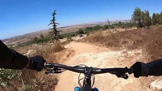
מסלולי התחרות , הפרסה+השחור בפארק קנדה משלבים מהירות בירידה, שטח מסולע ואגרסיבי לצד ברמים מגניבים, הרבה פידול ותאי שטח מגוונים, זמן אוויר -למי שאוהב לטוס יש מה לחפש פה אבל גם צריך כושר לפידול בעליות קצרות ומישור במגוון תאי שטח.
סטייג' 1 - https://www.strava.com/segments/14325808
סטייג' 2 - https://www.strava.com/segments/14325900

הסבר על התנהלות הרכיבה באירוע לפי קטגוריות

מתחרי קטגוריית ספרינט- אך ורק ילדים ונוער מגיל 8-13

שני ראנים נפרדים על מסלול בירידה בלבד, המתחרים בקטגורייה ירכבו על מסלול הפרסה בלבד
פורמט שני ראנים,הזמן הטוב מבין השניים הוא הזמן המייצג את תוצאת הרוכב.
לדוגמא: ראן 1 : 3:00 דק' ראן 2 : 3:04 דק', תוצאת הרוכב לצרכי דירוג = 3:00 דק'.
עלייה מנהלתית ברכובה או ברכב,הגעה בזמן לשעת ההזנקה באחריות הרוכבים/משפחותיהם או קבוצת הרכיבה.


מתחרי קטגוריות האינדורו - מגיל ,12,13 עד 50+

כל המתחרים ישתתפו בקטגוריית האינדורו, מסלול רכיבה הקפי הכולל עליות התשה במסגרת זמן מחייבת, קטגוריית צ'אלנג' 60 דק' קטגוריית פרו 60 דק' זמן מסגרת להתשה.
קטגוריית הפרו פונה לקומץ רוכבים מקצועיים מצומצם וקטגוריית הצאלנג' הינה הקטגוריה אליה 80% מהמשתתפים פונים.
הגעה לנקודת ההזנקה והתייצבות להזנקת ראן המדידה(סטייג') בירידה באחריות הרוכב ע"פ הזמנים שימסרו בבוקר התחרות, רוכב שלא יגיע בזמן ו/או לא דאג לזנק בזמן ההזנקה שנקבע לו יפסל הראן, רוכב שתהיה לו תקלה טכנית ולא יגיע בזמן להזנקה יפסל הראן, רוכב שיהיה בשטח בזמן ולא ישים לב שקוראים לו יפסל הראן.
בתחרות אינדורו הרוכב מזנק לרכיבת התשה של מספר קילומטרים (תלוי קטגורייה) במגמת עלייה, את אותה התשה יש לסיים במסגרת הזמן שהוקצבה אך היא איננה מחושבת לתוצאת הרוכב הכללית בסוף היום. תוצאת סכום המדידות ברכיבה הטכנית במורד(סטייג'ים) היא תוצאת הרוכב המייצגת לצרכי דירוג.
לדוגמא: ראן בירידה על סטייג' 1 - 3:00 דק' + ראן בירידה על סטייג' 2 3:40 דק' = תוצאת הרוכב בסוף היום 6:40 דק'.

נקודת כינוס ומתחם אירוע - חניון עליון, פארק איילון (קנדה)

תיאור ונתוני מסלולי התחרות -

הרכיבה באירוע על בסיס סינגל קק"ל ביער פארק קנדה, האדום והשחור,
מדידות אינדורו צ'אלנג' , 2 סטייג'ים, האחד על הפרסה (אדום) והשני על השחור, בירידה בלבד - מסומן במפה בקווים אדומים ושחורים עבים. אינדורו פרו 3 סטייג'ים - פרסה +פרסה+שחור.
עליית התשה אל הסטייגי'ם במסגרת זמן 60 דק' לק. אינדורו צ'אלנג' ו 60 דק' לק. אינדורו פרו - מסומן במפה בקווים אדומים ושחורים מקווקוים.
עלייות ההתשה עוברות בכל פעם בשטח הכינוס - חניון עליון פארק קנדה.

Detailed Description
ליגת אינדורו - פארק קנדה is a 13 mile intermediate race route located near Canada Park. This mountain bike only route. This route includes 3 trails. This route climbs 1,339 ft with a max elevation of 1,297 ft then descends -1,686 ft.
Past Events

Stats

  • Distance
    13 miles
  • Avg time
    1 hr 47 min
  • Altitude change
    -347 ft
  • Altitude min
    738 ft
  • Altitude start
    1,236 ft
  • Altitude end
    889 ft
  • Climb
    1,339 ft
  • Descent
    -1,686 ft
  • Grade
    -0.5%
  • Grade max
    -36.7%
  • Grade min
    24.7%
  • Distance climb
    6 miles
  • Distance down
    6 miles
  • Distance flat
    2 miles

2 Reviews & Comments


We hope you've been enjoying Trailforks!

Create a FREE account to view route comments and much more.

Route Sections

1 Stage 1 - Horseshoe
  • 2 miles distance
  • 132 ft climb
  • -464 ft descent
2 Stage 2 - The Black
  • 5,007 ft distance
  • 3 ft climb
  • -365 ft descent

Trails in Route

Bathtubs2,257 ft
The Black4,590 ft

Details

  • Race Course
  • Riding area
  • Primary Activity
    Mountain Bike
  • Difficulty rating
    Blue
  • Bike type
    AM
  • Ridelogs
    371
no votes yet
close
3D
Trail Conditions
  • Unknown
  • Snow Groomed
  • Snow Packed
  • Snow Covered
  • Snow Cover Partial
  • Freeze/thaw Cycle
  • Icy
  • Prevalent Mud
  • Wet
  • Variable
  • Ideal
  • Dry
  • Very Dry
Trail Flow (Ridden Direction)
Trailforks scans users ridelogs to determine the most popular direction each trail is ridden. A good flowing trail network will have most trails flowing in a single direction according to their intension.
The colour categories are based on what percentage of riders are riding a trail in its intended direction.
  • > 96%
  • > 90%
  • > 80%
  • > 70%
  • > 50%
  • < 50%
  • bi-directional trail
  • no data
Trail Last Ridden
Trailforks scans ridelogs to determine the last time a trail was ridden.
  • < 2 days
  • < 1 week
  • < 2 weeks
  • < 1 month
  • < 6 months
  • > 6 months
Trail Ridden Direction
The intended direction a trail should be ridden.
  • Downhill Only
  • Downhill Primary
  • Both Directions
  • Uphill Primary
  • Uphill Only
  • One Direction
Contribute Details
Colors indicate trail is missing specified detail.
  • Description
  • Photos
  • Description & Photos
  • Videos
Trail Popularity ?
Trailforks scans ridelogs to determine which trails are ridden the most in the last 9 months. Trails are compared with nearby trails in the same city region with a possible 25 colour shades. Think of this as a heatmap, more rides = more kinetic energy = warmer colors.
  • most popular
  • popular
  • less popular
  • not popular
ATV/ORV/OHV Filter
Max Vehicle Width
inches
US Cell Coverage
Legend
cell carrier legend

Radar Time
Activity Recordings
Trailforks uses anonymized public activity data. ?
Activity Recordings
Trailforks uses anonymized public activity data. ?
Personal Heatmap
Activity Types
all / none
Options
2
Date range month
Winter Trails
Warning A routing network for winter maps does not exist. Selecting trails using the winter trails layer has been disabled.
Missing Trails
Most Popular
Least Popular
Trails are colored based on popularity. The more popular a trail is, the more red. Less popular trails trend towards green.
Jump Magnitude Heatmap
Heatmap of where riders jump on trails. Zoom in to see individual jumps, click circles to view jump details.
BC Backroad Status

Service Road Atlas is a free to use, community-driven service for viewing and creating reports on the numerous back-country service roads around B.C. and Alberta.

map legend
Slope Aspect
Direction the slope faces
Flat N NE E SE S SW W NW
Trails Deemphasized
Trails are shown in grey.
disable
Only show trails with no bike usage.
Enable
Suggested Layers
Based on selected activity type

    Save the current map location and zoom level as your default home location whenever this page is loaded.

    Save
    Trail transparency
    • Singletrack
    90
    97
    112

    Recent Trail Reports Along Route

    statustraildateconditiondescription
    The Black
    May 23, 2026 @ 7:48am (Asia/Jerusalem)
    May 22, 2026
    Very loose
    Bathtubs
    May 23, 2026 @ 7:48am (Asia/Jerusalem)
    May 22, 2026
    more reports »
    • By ziv2102TF Pro TRAILFORKS & contributors
    • #6551 - 1,886 views

    Hit the Trail

    Open in App

    Get this route on your phone instantly.

    Download Route

    Save to wishlist, Garmin & download.