10.1 miles
Distance
2,187 ft
Climb
-2,185 ft
Descent
2 miles
High Point
0 ft
Altitude change
7,740 ft
Altitude min
7,740 ft
Altitude start
7,740 ft
Altitude end
-54.5%
Grade max
40.2%
Grade min
5 miles
Distance climb
5 miles
Distance down
3,245 ft
Distance flat

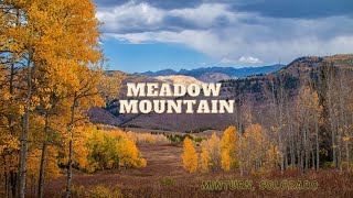
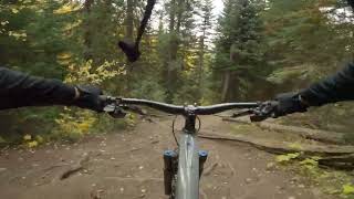
Start at the Meadow Mountain parking lot, climb line shack, descend Whiskey Creek to Everkrisp trail and back to Minturn.

Detailed Description
WhiskeyKrisp is a 10 mile popular expert route located near Minturn Colorado. This mountain bike only route. This route includes 3 trails. This route climbs 2,187 ft with a max elevation of 9,751 ft then descends -2,185 ft.

Trail Issues on Route

  • Closed: 2 trails (newest: Nov 23, 2025)
  • Minor Issue / Yellow: 1 trail (newest: Aug 29, 2025)
Local Trail Association
Please consider joining or donating to the local riding association to support trail development & maintenance.
Donate to earn trail karma!

Stats

  • Distance
    10 miles
  • Avg time
    1 hr 40 min
  • Altitude change
    0 ft
  • Altitude min
    7,740 ft
  • Altitude start
    7,740 ft
  • Altitude end
    7,740 ft
  • Climb
    2,187 ft
  • Descent
    -2,185 ft
  • Grade max
    -54.5%
  • Grade min
    40.2%
  • Distance climb
    5 miles
  • Distance down
    5 miles
  • Distance flat
    3,245 ft

15 Reviews & Comments


We hope you've been enjoying Trailforks!

Create a FREE account to view route comments and much more.

Trails in Route

Details

  • Riding area
  • Primary Activity
    Mountain Bike
  • Difficulty rating
    Black Diamond
  • Ridelogs
    227
Avg: 3.7 (7 votes)
close
3D
Trail Conditions
  • Unknown
  • Snow Groomed
  • Snow Packed
  • Snow Covered
  • Snow Cover Partial
  • Freeze/thaw Cycle
  • Icy
  • Prevalent Mud
  • Wet
  • Variable
  • Ideal
  • Dry
  • Very Dry
Trail Flow (Ridden Direction)
Trailforks scans users ridelogs to determine the most popular direction each trail is ridden. A good flowing trail network will have most trails flowing in a single direction according to their intension.
The colour categories are based on what percentage of riders are riding a trail in its intended direction.
  • > 96%
  • > 90%
  • > 80%
  • > 70%
  • > 50%
  • < 50%
  • bi-directional trail
  • no data
Trail Last Ridden
Trailforks scans ridelogs to determine the last time a trail was ridden.
  • < 2 days
  • < 1 week
  • < 2 weeks
  • < 1 month
  • < 6 months
  • > 6 months
Trail Ridden Direction
The intended direction a trail should be ridden.
  • Downhill Only
  • Downhill Primary
  • Both Directions
  • Uphill Primary
  • Uphill Only
  • One Direction
Contribute Details
Colors indicate trail is missing specified detail.
  • Description
  • Photos
  • Description & Photos
  • Videos
Trail Popularity ?
Trailforks scans ridelogs to determine which trails are ridden the most in the last 9 months. Trails are compared with nearby trails in the same city region with a possible 25 colour shades. Think of this as a heatmap, more rides = more kinetic energy = warmer colors.
  • most popular
  • popular
  • less popular
  • not popular
ATV/ORV/OHV Filter
Max Vehicle Width
inches
US Cell Coverage
Legend
cell carrier legend

Radar Time
Activity Recordings
Trailforks uses anonymized public activity data. ?
Activity Recordings
Trailforks uses anonymized public activity data. ?
Personal Heatmap
Activity Types
all / none
Options
2
Date range month
Winter Trails
Warning A routing network for winter maps does not exist. Selecting trails using the winter trails layer has been disabled.
Missing Trails
Most Popular
Least Popular
Trails are colored based on popularity. The more popular a trail is, the more red. Less popular trails trend towards green.
Jump Magnitude Heatmap
Heatmap of where riders jump on trails. Zoom in to see individual jumps, click circles to view jump details.
BC Backroad Status

Service Road Atlas is a free to use, community-driven service for viewing and creating reports on the numerous back-country service roads around B.C. and Alberta.

map legend
Slope Aspect
Direction the slope faces
Flat N NE E SE S SW W NW
Trails Deemphasized
Trails are shown in grey.
disable
Only show trails with no bike usage.
Enable
Suggested Layers
Based on selected activity type

    Save the current map location and zoom level as your default home location whenever this page is loaded.

    Save
    Trail transparency
    • Singletrack
    47
    43
    41
    39
    Meadow Mountain - Whiskey Creek - Everkrisp
    Meadow Mountain - Whiskey Creek - Everkrisp
    8:11 | 4 | comments: 0 | favs:
    Jun 18, 2026
    Arrowhead to Minturn
    Arrowhead to Minturn
    trail: Everkrisp
    9:37 | 94 | comments: 0 | favs:
    Aug 5, 2024

    Recent Trail Reports Along Route

    statustraildateconditiondescription
    Whiskey Creek
    Nov 23, 2025 @ 1:00am (America/Denver)
    Nov 23, 2025
    reporter
    Everkrisp
    Nov 23, 2025 @ 1:00am (America/Denver)
    Nov 23, 2025
    reporter
    Whiskey Creek
    Oct 21, 2025 @ 9:27pm (America/Denver)
    Oct 21, 2025
    Snowy above 9000'
    Everkrisp
    Sep 12, 2025 @ 9:09am (America/Denver)
    Sep 12, 2025
    reporter
    Meadow Mountain
    Aug 29, 2025 @ 11:03am
    Aug 29, 2025
    Good condition, 99% dry after rain
    more reports »
    • By esaeger1TF Pro VVMTA & contributors
    • #14282 - 3,814 views

    Hit the Trail

    Open in App

    Get this route on your phone instantly.

    Download Route

    Save to wishlist, Garmin & download.