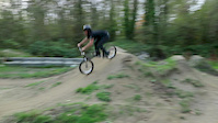
Vanier Park dirt jump park. Built in 2010. Small bowl-style pump track. Two large trails with gap jumps/hips etc. Some fairly steep lips and landings.
Small line of tables in the middle, completed Spring 2018.
Pump track added Sept 2019 by Joyride bike parks( it’s Very fast.)
There is a lockable shipping container for tool storage.
Email [email protected] or Facebook "Vancouver Dirt Jump Coalition" or instagram "@vancouverdirtjumps" to get involved and for updates.
Skillpark Features
Reports
| status | date | description |
|---|---|---|
Aug 31, 2023 @ 1:13pm Aug 31, 2023 | Was very dry, recent rains and the wednesday dig & ride have it running like a dream. view | |
Feb 13, 2022 @ 6:59am Feb 13, 2022 | Prevalent mud view | |
Jun 3, 2021 @ 5:55am Jun 3, 2021 | Opened back up in May. Good to go, everything is good. Water is back on...please water the jumps (if it's dry) before, during & after... view | |
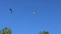
Apr 22, 2021 @ 5:59pm Apr 22, 2021 | Closed by Vancouver Parks due to eagles nesting. :( Scheduled to be opened in May. check @vancouverdirtjumps for updates. Fifth jump on... view | |
Nov 21, 2020 @ 8:32am Nov 21, 2020 | Mud!!! Rainy season is here and the jumps aren’t really rideable. If you are causing ruts, it’s too wet. Smallest set is okay—don’t... view |
close
-
Layers w
- Weather Layers
- Pro
- Pro
- Pro
- Pro
- Pro
- Pro
- More Layers
- Pro
- Pro
- Pro
- Pro
-
Upgrade to

3D
Trail Conditions
- Unknown
- Snow Groomed
- Snow Packed
- Snow Covered
- Snow Cover Partial
- Freeze/thaw Cycle
- Icy
- Prevalent Mud
- Wet
- Variable
- Ideal
- Dry
- Very Dry
Trail Flow (Ridden Direction)
Trailforks scans users ridelogs to determine the most popular direction each trail is ridden. A good flowing trail network will have most trails flowing in a single direction according to their intension.
The colour categories are based on what percentage of riders are riding a trail in its intended direction.
The colour categories are based on what percentage of riders are riding a trail in its intended direction.
- > 96%
- > 90%
- > 80%
- > 70%
- > 50%
- < 50%
- bi-directional trail
- no data
Trail Last Ridden
Trailforks scans ridelogs to determine the last time a trail was ridden.
- < 2 days
- < 1 week
- < 2 weeks
- < 1 month
- < 6 months
- > 6 months
Trail Ridden Direction
The intended direction a trail should be ridden.
- Downhill Only
- Downhill Primary
- Both Directions
- Uphill Primary
- Uphill Only
- One Direction
Contribute Details
Colors indicate trail is missing specified detail.
- Description
- Photos
- Description & Photos
- Videos
Trail Popularity ?
Trailforks scans ridelogs to determine which trails are ridden the most in the last 9 months.
Trails are compared with nearby trails in the same city region with a possible 25 colour shades.
Think of this as a heatmap, more rides = more kinetic energy = warmer colors.
- most popular
- popular
- less popular
- not popular
ATV/ORV/OHV Filter
Max Vehicle Width
inches
US Cell Coverage
Legend

Radar Time
Activity Recordings
Trailforks uses anonymized public activity data.
?
Activity Recordings
Trailforks uses anonymized public activity data.
?
Personal Heatmap
▶
Activity Types
all
/
none
▶
Options
2
Date range
month
–
Winter Trails
Warning
A routing network for winter maps does not exist. Selecting trails using the winter trails layer has been disabled.
Missing Trails
Most Popular
Least Popular
Trails are colored based on popularity. The more popular a trail is, the more red. Less popular trails trend towards green.
Jump Magnitude Heatmap
Heatmap of where riders jump on trails. Zoom in to see individual jumps, click circles to view jump details.
BC Backroad Status
![map legend]()
Service Road Atlas is a free to use, community-driven service for viewing and creating reports on the numerous back-country service roads around B.C. and Alberta.

Slope Aspect
Direction the slope faces
Trails Deemphasized
Trails are shown in grey.
Only show trails with no bike usage.
Suggested Layers
Based on selected activity type
Save the current map location and zoom level as your default home location whenever this page is loaded.
Save- Vancouver, BC Canada
- Google map
Photos
Videos
Vanier, finishing small set
0:45 | 136 | comments: 0 | favs:
Jul 31, 2018
Finished the last part of the small set.
July 2018
Vanier Park, Vancouver, BC
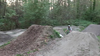
Vanier closing day 2017
0:05 | 442 | comments: 0 | favs: 1
Nov 2, 2017
Last day of good riding at Vanier for 2017...
Kyle B, Scribbs, Stu, Philip, Lucas, Daniel
misc vanier
0:27 | 179 | comments: 0 | favs:
Oct 3, 2017
Vanier park
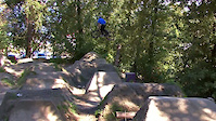
A Day at Vanier Park with Cole Swanson
0:54 | 7489 | comments: 24 | favs: 206
Aug 29, 2011
For HD version go to: http://vimeo.com/28256221 -- you can also like us on Facebook to keep up with the latest content!...
5 Comments
- + 1
Big set and medium set are OPEN. Smallest set is closed, while the jumps get bigger. "Vancouver Dirt Jump Coalition" on Facebook for updates, or email [email protected]
- By BCpov
 & contributors
 - #348 - 13,917 views
If it's dry, wet it down lightly with the hose at the north side of the trails before you ride.
Watch this video before you go:
vimeo.com/16262338
also check out Vancouver Dirt Jump Coalition on Facebook