
Open in App
Get this trail on your phone instantly.

This track goes the opposite way I biked, so keep that in mind when you read this.
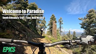
Starting at near the summit of Sierra de Don Fernando, you descend on FR 164 for a bit before hopping on South Boundary.
Once you're on SB, pop your bike in the highest gear and crank away down this long slightly downhill traverse across the side of the hill.
The trail is pretty smooth, so you can go pretty fast.
There's almost 3 miles of this kind of trail before you hit a nice field.
Head up the hill to the left if you want a nice view north.
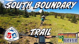
From here the trail changes a bit into some tighter and rooty sections.
Watch those sharp corners and roots
As you get lower, things go from rooty, to rocky.
Take a slight right onto FR 437 to continue down the SB trail.
Right at the end there's a rollover on a tree. It looks like a drop, but there's some flat rocks on the back that make this pretty easy if you're going slow.
Not sure who would ride up this...it would be terrible.
| c1 | c2 | c3 | c4 |
|---|---|---|---|
January | February | March | April |
May | June | July | August |
September | October | November | December |

Service Road Atlas is a free to use, community-driven service for viewing and creating reports on the numerous back-country service roads around B.C. and Alberta.
Save the current map location and zoom level as your default home location whenever this page is loaded.
Save
No reviews yet, be the first to write a review or ask a question.
Use trail reports to comment on trail conditions.
We hope you've been enjoying Trailforks!
Create a FREE account to view trail comments and much more.
You must enter a description before submitting.

