more stats
3,405 ft
Distance
-932 ft
Descent
00:07:43
Avg time
-932 ft
Altitude change
3,128 ft
Altitude min
4,060 ft
Altitude max
4,060 ft
Altitude start
3,128 ft
Altitude end
-27.362%
Grade
-46.238%
Grade max
-4.76%
Grade min
3,405 ft
Distance down
00:07:43
Avg time

001 Details

  • Activities
    • Mountain Bike
    • Hike
    • Trail Running
  • Riding Area
    Canfield Mountain Trail System
    Coeur d'Alene, Idaho
  • Difficulty Rating
  • Voted Difficulty
    Double Black Diamond (1 vote)
  • Local Popularity
    50 in Mountain Biking [+]
    • 90 in Trail Running
    • 95 in Hiking
  • Global Ranking
    #123694 in Mountain Biking [+]
    • #50560 in Trail Running
    • #23238 in Hiking
  • Trail Type
    Singletrack
  • Bike Type
    DH, AM, XC, DJ
  • Direction
    Both Directions
    Popular Direction Shown
  • Season
    spring, summer, fall
  • Dogs Allowed
    Yes
  • TTFs on Trail
    Berm, Drop, Jump, Gap Jump, Ladder Bridge
  • Ride in Rain
    Yes

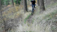
The upper portion of trail 001 is steep and similar to "black diamond" difficulty rating but the lower is "blue square" look for the Matt Johnson jump line as you enter the Miner's Loop area

Trail Supporters

  • USFS
    Land Manager
Local Trail Association
Traditionally Indigenous Territory

Recent Activity on Trail

Past Week
  • 0 rides
  •  
6 Months
  • 6 rides
  • 13 miles avg distance
All
  • 23 rides
  • Last: Jun 6, 2026
c1c2c3c4
January
February
March
April
May
June
July
August
September
October
November
December
update trails status or condition

001 Trail Reports

statusdatedescription
Mar 8, 2026 @ 2:43pm (America/Los_Angeles)
Mar 8, 2026
perfect brown powder (although the road traversing to the top of the trail is a mess)
Feb 5, 2026 @ 4:57pm (America/Los_Angeles)
Feb 5, 2026
good dirt dont kill a hiker (and beware of a few downed trees)
Jan 28, 2026 @ 6:45pm (America/Los_Angeles)
Jan 28, 2026
apparently a blast when its frosty and the dirt is frozen. rode 4 days ago. probably muddy now
Aug 31, 2025 @ 11:03am
Aug 31, 2025
moondust
Jul 2, 2023 @ 8:36pm
Jul 2, 2023
more »
Status:
on Mar 8, 2026
Ideal
Avg: 3.28 (8 votes)
Your vote: 0

view (579)
close
3D
Trail Conditions
  • Unknown
  • Snow Groomed
  • Snow Packed
  • Snow Covered
  • Snow Cover Partial
  • Freeze/thaw Cycle
  • Icy
  • Prevalent Mud
  • Wet
  • Variable
  • Ideal
  • Dry
  • Very Dry
Trail Flow (Ridden Direction)
Trailforks scans users ridelogs to determine the most popular direction each trail is ridden. A good flowing trail network will have most trails flowing in a single direction according to their intension.
The colour categories are based on what percentage of riders are riding a trail in its intended direction.
  • > 96%
  • > 90%
  • > 80%
  • > 70%
  • > 50%
  • < 50%
  • bi-directional trail
  • no data
Trail Last Ridden
Trailforks scans ridelogs to determine the last time a trail was ridden.
  • < 2 days
  • < 1 week
  • < 2 weeks
  • < 1 month
  • < 6 months
  • > 6 months
Trail Ridden Direction
The intended direction a trail should be ridden.
  • Downhill Only
  • Downhill Primary
  • Both Directions
  • Uphill Primary
  • Uphill Only
  • One Direction
Contribute Details
Colors indicate trail is missing specified detail.
  • Description
  • Photos
  • Description & Photos
  • Videos
Trail Popularity ?
Trailforks scans ridelogs to determine which trails are ridden the most in the last 9 months. Trails are compared with nearby trails in the same city region with a possible 25 colour shades. Think of this as a heatmap, more rides = more kinetic energy = warmer colors.
  • most popular
  • popular
  • less popular
  • not popular
ATV/ORV/OHV Filter
Max Vehicle Width
inches
US Cell Coverage
Legend
cell carrier legend

Radar Time
Activity Recordings
Trailforks uses anonymized public activity data. ?
Activity Recordings
Trailforks uses anonymized public activity data. ?
Personal Heatmap
Activity Types
all / none
Options
2
Date range month
Winter Trails
Warning A routing network for winter maps does not exist. Selecting trails using the winter trails layer has been disabled.
Missing Trails
Most Popular
Least Popular
Trails are colored based on popularity. The more popular a trail is, the more red. Less popular trails trend towards green.
Jump Magnitude Heatmap
Heatmap of where riders jump on trails. Zoom in to see individual jumps, click circles to view jump details.
BC Backroad Status

Service Road Atlas is a free to use, community-driven service for viewing and creating reports on the numerous back-country service roads around B.C. and Alberta.

map legend
Slope Aspect
Direction the slope faces
Flat N NE E SE S SW W NW
Trails Deemphasized
Trails are shown in grey.
disable
Only show trails with no bike usage.
Enable
Suggested Layers
Based on selected activity type

    Save the current map location and zoom level as your default home location whenever this page is loaded.

    Save
        Directions to 001 trailhead (47.731370, -116.731470)

        Photos

        4 more »
        50 |
        Sep 1, 2025 @ 6:08am
        Sep 1, 2025
        44 |
        Sep 1, 2025 @ 6:07am
        Sep 1, 2025
        399 |
        Jul 2, 2018 @ 10:57am
        Jul 2, 2018
        387 |
        Jan 29, 2017 @ 9:28am
        Jan 29, 2017

        Videos

        3 more »
        Fall Edit 2.0
        0:02 | 429 | Jan 29, 2017 , Coeur d'Alene
        A Winter Shred
        0:04 | 204 | Jan 29, 2017 , Coeur d'Alene
        Fall Edit 1.0
        0:16 | 285 | Jan 29, 2017 , Coeur d'Alene

        Routes with this trail

        12 miles 3,162 ft 22 Race
        Transfer 5 - Coeur d'Alene Enduro event site up the service road to . Up to Penn Station. Continue up to...
        2.0 12 miles 3,167 ft 4 Race
        Transfer 5 - Jacklin Property up service road to . to . to the Island and up road 1562 to . Up to the top...

        Trail Products

        1 Review & Comments


        We hope you've been enjoying Trailforks!

        Create a FREE account to view trail comments and much more.

        • By iceage & contributors
        • #23556 - 3,981 views

        Frequently Asked Questions About 001

        Where is 001 located?
        001 is located in Canfield Mountain Trail System, Coeur d'Alene, Idaho, United States. It is part of the Canfield Mountain Trail System trail network. The trailhead is located at coordinates 47.73137, -116.73147.
        How hard is 001?
        001 is rated as Black Diamond difficulty. The average grade is 27.362%.
        What is the elevation gain for 001?
        The trail has 284 m of elevation descent. The elevation ranges from 953 m to 1,237 m.
        Is 001 a point to point trail?
        001 is not a point to point trail. The direction is Both Directions. The trail type is singletrack.

        Hit the Trail

        Open in App

        Get this trail on your phone instantly.
        open trail in app

        Download Trail

        Save to wishlist, Garmin & download.
        save the trail

        Find Related Routes

        Find routes and users activities that include this trail.
        find routes for this trail

        You must enter a description before submitting.