more stats
4,698 ft
Distance
51 ft
Climb
-297 ft
Descent
00:03:46
Avg time
-247 ft
Altitude change
985 ft
Altitude min
1,240 ft
Altitude max
1,235 ft
Altitude start
988 ft
Altitude end
-5.3%
Grade
-29.3%
Grade max
15.2%
Grade min
1,007 ft
Distance climb
2,690 ft
Distance down
942 ft
Distance flat
00:03:46
Avg time

101 Kleeway Details

  • Activities
    • Mountain Bike
    • E-Bike
  • Riding Area
    Post Canyon
    Hood River, Oregon
  • Difficulty Rating
  • Voted Difficulty
    Blue (2 votes)
  • Local Popularity
    100 in Mountain Biking [+]
    • 95 in E-Biking
  • Global Ranking
    #10094 in Mountain Biking [+]
    • #653 in E-Biking
  • Trail Type
    Singletrack
  • Bike Type
    DH, AM, XC, DJ
  • Direction
    Downhill Only
    Popular Direction Shown
  • Physical Rating
    Moderate
  • Dogs Allowed
    Yes
  • eBike Allowed
    Yes up to Class 1
  • TTFs on Trail
    Berm, Jump, Gap Jump, Roller Coaster
  • Land Owner

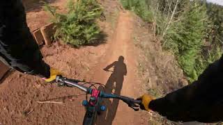
Kleeway is a bench cut jump and berm flow trail. Features generally offer three options: ride around, table, and gap options. Difficult to make everything if the wind is up since this is on a clear cut side hill. You can hot lap this using Seven Streams and the connector trial right out of the Seven Streams Staging area parking lot.

Local Trail Association

Recent Activity on Trail

Past Week
  • 38 rides
  • 12 miles average
6 Months
  • 481 rides
  • 13 miles avg distance
All
  • 5,950 rides
  • Last: Jun 18, 2026
c1c2c3c4
January
February
March
April
May
June
July
August
September
October
November
December
update trails status or condition

101 Kleeway Trail Reports

statusdatedescription
Jun 14, 2026 @ 9:03am (America/Los_Angeles)
Jun 14, 2026
Dry as always, Also the foliage on the edges of the trail are in dire need of a trim. I was getting slapped in the arm/torso constantly and it...
May 15, 2026 @ 3:14pm (America/Los_Angeles)
May 15, 2026
May 14, 2026 @ 12:46pm (America/Los_Angeles)
May 14, 2026
Brown Pow! Perfect after the recent rain
Mar 23, 2026 @ 4:40pm (America/Los_Angeles)
Mar 23, 2026
Was running great. Probably the best trail to run right now.
Oct 25, 2025 @ 10:28am (America/Vancouver)
Oct 25, 2025
more »
Status:
on Jun 14, 2026
Very Dry
Avg: 4.33 (74 votes)
Your vote: 0

view (28,971)
close
3D
Trail Conditions
  • Unknown
  • Snow Groomed
  • Snow Packed
  • Snow Covered
  • Snow Cover Partial
  • Freeze/thaw Cycle
  • Icy
  • Prevalent Mud
  • Wet
  • Variable
  • Ideal
  • Dry
  • Very Dry
Trail Flow (Ridden Direction)
Trailforks scans users ridelogs to determine the most popular direction each trail is ridden. A good flowing trail network will have most trails flowing in a single direction according to their intension.
The colour categories are based on what percentage of riders are riding a trail in its intended direction.
  • > 96%
  • > 90%
  • > 80%
  • > 70%
  • > 50%
  • < 50%
  • bi-directional trail
  • no data
Trail Last Ridden
Trailforks scans ridelogs to determine the last time a trail was ridden.
  • < 2 days
  • < 1 week
  • < 2 weeks
  • < 1 month
  • < 6 months
  • > 6 months
Trail Ridden Direction
The intended direction a trail should be ridden.
  • Downhill Only
  • Downhill Primary
  • Both Directions
  • Uphill Primary
  • Uphill Only
  • One Direction
Contribute Details
Colors indicate trail is missing specified detail.
  • Description
  • Photos
  • Description & Photos
  • Videos
Trail Popularity ?
Trailforks scans ridelogs to determine which trails are ridden the most in the last 9 months. Trails are compared with nearby trails in the same city region with a possible 25 colour shades. Think of this as a heatmap, more rides = more kinetic energy = warmer colors.
  • most popular
  • popular
  • less popular
  • not popular
ATV/ORV/OHV Filter
Max Vehicle Width
inches
US Cell Coverage
Legend
cell carrier legend

Radar Time
Activity Recordings
Trailforks uses anonymized public activity data. ?
Activity Recordings
Trailforks uses anonymized public activity data. ?
Personal Heatmap
Activity Types
all / none
Options
2
Date range month
Winter Trails
Warning A routing network for winter maps does not exist. Selecting trails using the winter trails layer has been disabled.
Missing Trails
Most Popular
Least Popular
Trails are colored based on popularity. The more popular a trail is, the more red. Less popular trails trend towards green.
Jump Magnitude Heatmap
Heatmap of where riders jump on trails. Zoom in to see individual jumps, click circles to view jump details.
BC Backroad Status

Service Road Atlas is a free to use, community-driven service for viewing and creating reports on the numerous back-country service roads around B.C. and Alberta.

map legend
Slope Aspect
Direction the slope faces
Flat N NE E SE S SW W NW
Trails Deemphasized
Trails are shown in grey.
disable
Only show trails with no bike usage.
Enable
Suggested Layers
Based on selected activity type

    Save the current map location and zoom level as your default home location whenever this page is loaded.

    Save
        Directions to 101-kleeway trailhead (45.684460, -121.604630)

        Photos

        15 more »
        564 |
        May 6, 2021 @ 5:05pm
        May 6, 2021
        424 |
        Apr 1, 2021 @ 3:18pm
        Apr 1, 2021
        537 |
        Apr 28, 2019 @ 1:51pm
        Apr 28, 2019
        700 |
        Feb 21, 2019 @ 3:10pm
        Feb 21, 2019

        Videos

        11 more »
        youtuber Kleeway - Post Canyon - Hood River, OR
        3:46 | 796 | Sep 12, 2022 , Hood River
        Kleeway 101-Post Canyon MTB
        2:06 | 55 | Apr 1, 2026 , Hood River
        Fall Flow in Post Canyon - Hood River Oregon
        24:10 | 75 | Dec 5, 2025 , Hood River
        Kleeway @ Post Canyon Trails
        4:17 | 211 | Nov 3, 2024 , Hood River

        Routes with this trail

        7 miles 296 ft 14
        Great route for a Shuttle!
        5.0 16 miles 1,493 ft 7 Loop
        Enjoy a tour of Post Canyon’s green trails starting from Oregon E-Bikes. This route includes a few...
        5.0 25 miles 3,205 ft 16 Loop
        Linking up Post Canyon's most popular trails for an eMTB adventure that gives you a little taste of...

        Trail Products

        5 Reviews & Comments


        We hope you've been enjoying Trailforks!

        Create a FREE account to view trail comments and much more.

        • By nkrohanTF Pro HRATS & contributors
        • #54165 - 16,290 views

        Frequently Asked Questions About 101 Kleeway

        Where is 101 Kleeway located?
        101 Kleeway is located in Post Canyon, Hood River, Oregon, United States. It is part of the Post Canyon trail network. The trailhead is located at coordinates 45.68446, -121.60463.
        How hard is 101 Kleeway?
        101 Kleeway is rated as Blue difficulty. The physical rating is Moderate. The average grade is 5.3%.
        What is the elevation gain for 101 Kleeway?
        101 Kleeway has 51 ft of elevation gain. The trail has 297 ft of elevation descent. The elevation ranges from 985 ft to 1,240 ft.
        Is 101 Kleeway a point to point trail?
        Yes, 101 Kleeway is a point to point trail. The direction is Downhill Only. The trail type is singletrack.

        Hit the Trail

        Open in App

        Get this trail on your phone instantly.
        open trail in app

        Download Trail

        Save to wishlist, Garmin & download.
        save the trail

        Find Related Routes

        Find routes and users activities that include this trail.
        find routes for this trail

        You must enter a description before submitting.