This trail is permanently closed/decommissioned
more stats
1,726 ft
Distance
-338 ft
Descent
00:06:11
Avg time
-337 ft
Altitude change
1,689 ft
Altitude min
2,029 ft
Altitude max
2,029 ft
Altitude start
1,693 ft
Altitude end
-19.5%
Grade
-105.3%
Grade max
4%
Grade min
20 ft
Distance climb
1,624 ft
Distance down
56 ft
Distance flat
00:06:11
Avg time

135 Blade Runner Details

  • Activities
    • Mountain Bike
    • E-Bike
  • Riding Area
    Post Canyon
    Hood River, Oregon
  • Ref Number
    #135
  • Difficulty Rating
  • Local Popularity
    20 in Mountain Biking [+]
    • 20 in E-Biking
  • Trail Type
    Singletrack
  • Bike Type
    DH, AM
  • Direction
    Downhill Only
    Popular Direction Shown
  • Physical Rating
    Moderate
  • Dogs Allowed
    Yes
  • eBike Allowed
    Yes up to Class 1
  • TTFs on Trail
    Berm, Drop, Jump
  • Land Owner
    HRC Forestry Dept

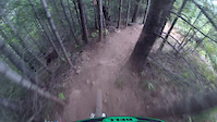
[closed indefinitely due to damage from 2024 Whiskey Creek fire line]

Steep, technical line dropping down a knife edge ridgeline. Several jumps on top before it gets steeper. End of the trail contains a drop which cannot be rolled.

Trail Supporters
Local Trail Association

Recent Activity on Trail

Past Week
  • 0 rides
  •  
6 Months
  • 0 rides
  •  
All
  • 272 rides
  • Last: Apr 4, 2026
c1c2c3c4
January
February
March
April
May
June
July
August
September
October
November
December
Status:
on Sep 15, 2024
Avg: 4.52 (13 votes)
Your vote: 0

view (2,080)
close
3D
Trail Conditions
  • Unknown
  • Snow Groomed
  • Snow Packed
  • Snow Covered
  • Snow Cover Partial
  • Freeze/thaw Cycle
  • Icy
  • Prevalent Mud
  • Wet
  • Variable
  • Ideal
  • Dry
  • Very Dry
Trail Flow (Ridden Direction)
Trailforks scans users ridelogs to determine the most popular direction each trail is ridden. A good flowing trail network will have most trails flowing in a single direction according to their intension.
The colour categories are based on what percentage of riders are riding a trail in its intended direction.
  • > 96%
  • > 90%
  • > 80%
  • > 70%
  • > 50%
  • < 50%
  • bi-directional trail
  • no data
Trail Last Ridden
Trailforks scans ridelogs to determine the last time a trail was ridden.
  • < 2 days
  • < 1 week
  • < 2 weeks
  • < 1 month
  • < 6 months
  • > 6 months
Trail Ridden Direction
The intended direction a trail should be ridden.
  • Downhill Only
  • Downhill Primary
  • Both Directions
  • Uphill Primary
  • Uphill Only
  • One Direction
Contribute Details
Colors indicate trail is missing specified detail.
  • Description
  • Photos
  • Description & Photos
  • Videos
Trail Popularity ?
Trailforks scans ridelogs to determine which trails are ridden the most in the last 9 months. Trails are compared with nearby trails in the same city region with a possible 25 colour shades. Think of this as a heatmap, more rides = more kinetic energy = warmer colors.
  • most popular
  • popular
  • less popular
  • not popular
ATV/ORV/OHV Filter
Max Vehicle Width
inches
US Cell Coverage
Legend
cell carrier legend

Radar Time
Activity Recordings
Trailforks uses anonymized public activity data. ?
Activity Recordings
Trailforks uses anonymized public activity data. ?
Personal Heatmap
Activity Types
all / none
Options
2
Date range month
Winter Trails
Warning A routing network for winter maps does not exist. Selecting trails using the winter trails layer has been disabled.
Missing Trails
Most Popular
Least Popular
Trails are colored based on popularity. The more popular a trail is, the more red. Less popular trails trend towards green.
Jump Magnitude Heatmap
Heatmap of where riders jump on trails. Zoom in to see individual jumps, click circles to view jump details.
BC Backroad Status

Service Road Atlas is a free to use, community-driven service for viewing and creating reports on the numerous back-country service roads around B.C. and Alberta.

map legend
Slope Aspect
Direction the slope faces
Flat N NE E SE S SW W NW
Trails Deemphasized
Trails are shown in grey.
disable
Only show trails with no bike usage.
Enable
Suggested Layers
Based on selected activity type

    Save the current map location and zoom level as your default home location whenever this page is loaded.

    Save
        Directions to 135-blade-runner trailhead (45.682280, -121.624650)

        Photos

        8 more »
        293 |
        Mar 29, 2022 @ 8:40am
        Mar 29, 2022
        418 |
        Jul 21, 2018 @ 8:17am
        Jul 21, 2018
        678 |
        Jul 21, 2018 @ 8:17am
        Jul 21, 2018
        516 |
        May 21, 2018 @ 2:05pm
        May 21, 2018

        Videos

        4 more »
        Blade Runner Trail -- Post Canyon, Hood River, OR
        2:03 | 156 | May 25, 2024 , Hood River
        Blade Runner - Post Canyon - Hood River, Oregon
        4:43 | 830 | Apr 24, 2022 , Hood River
        youtuber Post Canyon - Part 1 (Hood, OR) Mountain Biking
        9:47 | 836 | Jul 3, 2019 , Hood River
        Hood River, PC, trail is Bladerunner
        0:54 | 1066 | Jul 28, 2015 , Hood River

        Routes with this trail

        5.0 22 miles 4,246 ft 13
        14 miles 964 ft 10 Shuttled
        Shuttled route starting at the top of Hidden and climb to the top of Dirt Surfer. This trail follows the...
        13 miles 1,801 ft 24
        demo trying to make this work

        Trail Products

        2 Reviews & Comments


        We hope you've been enjoying Trailforks!

        Create a FREE account to view trail comments and much more.

        Frequently Asked Questions About 135 Blade Runner

        Where is 135 Blade Runner located?
        135 Blade Runner is located in Post Canyon, Hood River, Oregon, United States. It is part of the Post Canyon trail network. The trailhead is located at coordinates 45.68228, -121.62465.
        How hard is 135 Blade Runner?
        135 Blade Runner is rated as Black Diamond difficulty. The physical rating is Moderate. The average grade is 19.5%.
        What is the elevation gain for 135 Blade Runner?
        The trail has 338 ft of elevation descent. The elevation ranges from 1,689 ft to 2,029 ft.
        Is 135 Blade Runner a point to point trail?
        Yes, 135 Blade Runner is a point to point trail. The direction is Downhill Only. The trail type is singletrack.

        Hit the Trail

        Open in App

        Get this trail on your phone instantly.
        open trail in app

        Download Trail

        Save to wishlist, Garmin & download.
        save the trail

        Find Related Routes

        Find routes and users activities that include this trail.
        find routes for this trail

        You must enter a description before submitting.