more stats
1.7 miles
Distance
18 ft
Climb
-565 ft
Descent
00:11:37
Avg time
-548 ft
Altitude change
586 ft
Altitude min
1,148 ft
Altitude max
1,134 ft
Altitude start
587 ft
Altitude end
-6.2%
Grade
-43.3%
Grade max
15.2%
Grade min
725 ft
Distance climb
2 miles
Distance down
226 ft
Distance flat
00:11:37
Avg time

3M Trail Details

  • Activities
    • Mountain Bike
    • Hike
    • Trail Running
  • Riding Area
    Chino Hills State Park
    Chino, California
  • Difficulty Rating
  • Local Popularity
    90 in Mountain Biking [+]
    • 65 in Trail Running
    • 65 in Hiking
  • Global Ranking
    #8753 in Mountain Biking [+]
    • #81020 in Trail Running
    • #78373 in Hiking
  • Hiking SAC Scale
    T1 Hiking
  • Trail Type
    Singletrack
  • Bike Type
    AM, XC
  • Direction
    Downhill Primary
    Popular Direction Shown
  • Climb Difficulty
    Blue
  • Physical Rating
    Moderate
  • Trail Visibility
    Sometimes hard to follow
  • eBike Allowed

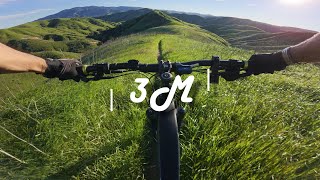
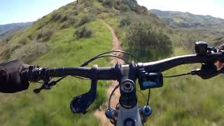
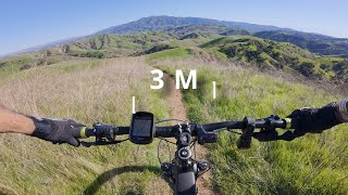
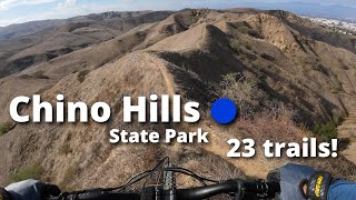
This is ridgeline type single track trail that links Long Way Around Trail down to Lower Aliso Trails. Much of the trail is downhill though there are a few climbs.
Trail is not used much and conditions may very depending on season. Trail is a little tight in spots with light exposure. Only risk would be a fall to lower grassy area. No cliffs or rocky areas.

Disclaimer

conditions may very depending on season

Traditionally Indigenous Territory

Recent Activity on Trail

Past Week
  • 1 rides
  • 25 miles average
6 Months
  • 45 rides
  • 18 miles avg distance
All
  • 98 rides
  • Last: Jun 15, 2026
c1c2c3c4
January
February
March
April
May
June
July
August
September
October
November
December
update trails status or condition

3M Trail Trail Reports

statusdatedescription
Mar 12, 2026 @ 8:38am (America/Los_Angeles)
Mar 12, 2026
In good shape for the first miles or so and then not so good. The trail is in good shape but you can't see it because of the low overgrowth.
Mar 3, 2026 @ 6:31pm (America/Los_Angeles)
Mar 3, 2026
Overgrown vegetation. Needs a good weed wackin.
Jan 9, 2026 @ 12:03pm (America/Los_Angeles)
Jan 9, 2026
Trails are perfect
Dec 8, 2025 @ 10:08am (America/Los_Angeles)
Dec 8, 2025
The bottom 1/3 of the trail is super bumpy because of the horse tracks. Otherwise, clear and very green.
Dec 5, 2025 @ 12:00pm (America/Los_Angeles)
Dec 5, 2025
running awesome! ideal
more »
Status:
on Mar 12, 2026
Dry
Avg: 4.24 (7 votes)
Your vote: 0

view (1,036)
close
3D
Trail Conditions
  • Unknown
  • Snow Groomed
  • Snow Packed
  • Snow Covered
  • Snow Cover Partial
  • Freeze/thaw Cycle
  • Icy
  • Prevalent Mud
  • Wet
  • Variable
  • Ideal
  • Dry
  • Very Dry
Trail Flow (Ridden Direction)
Trailforks scans users ridelogs to determine the most popular direction each trail is ridden. A good flowing trail network will have most trails flowing in a single direction according to their intension.
The colour categories are based on what percentage of riders are riding a trail in its intended direction.
  • > 96%
  • > 90%
  • > 80%
  • > 70%
  • > 50%
  • < 50%
  • bi-directional trail
  • no data
Trail Last Ridden
Trailforks scans ridelogs to determine the last time a trail was ridden.
  • < 2 days
  • < 1 week
  • < 2 weeks
  • < 1 month
  • < 6 months
  • > 6 months
Trail Ridden Direction
The intended direction a trail should be ridden.
  • Downhill Only
  • Downhill Primary
  • Both Directions
  • Uphill Primary
  • Uphill Only
  • One Direction
Contribute Details
Colors indicate trail is missing specified detail.
  • Description
  • Photos
  • Description & Photos
  • Videos
Trail Popularity ?
Trailforks scans ridelogs to determine which trails are ridden the most in the last 9 months. Trails are compared with nearby trails in the same city region with a possible 25 colour shades. Think of this as a heatmap, more rides = more kinetic energy = warmer colors.
  • most popular
  • popular
  • less popular
  • not popular
ATV/ORV/OHV Filter
Max Vehicle Width
inches
US Cell Coverage
Legend
cell carrier legend

Radar Time
Activity Recordings
Trailforks uses anonymized public activity data. ?
Activity Recordings
Trailforks uses anonymized public activity data. ?
Personal Heatmap
Activity Types
all / none
Options
2
Date range month
Winter Trails
Warning A routing network for winter maps does not exist. Selecting trails using the winter trails layer has been disabled.
Missing Trails
Most Popular
Least Popular
Trails are colored based on popularity. The more popular a trail is, the more red. Less popular trails trend towards green.
Jump Magnitude Heatmap
Heatmap of where riders jump on trails. Zoom in to see individual jumps, click circles to view jump details.
BC Backroad Status

Service Road Atlas is a free to use, community-driven service for viewing and creating reports on the numerous back-country service roads around B.C. and Alberta.

map legend
Slope Aspect
Direction the slope faces
Flat N NE E SE S SW W NW
Trails Deemphasized
Trails are shown in grey.
disable
Only show trails with no bike usage.
Enable
Suggested Layers
Based on selected activity type

    Save the current map location and zoom level as your default home location whenever this page is loaded.

    Save
        Directions to 3m-trail trailhead (33.917030, -117.688620)

        Photos

        16 more »
        42 |
        Sep 11, 2025 @ 7:39pm
        Sep 11, 2025
        53 |
        Sep 11, 2025 @ 7:39pm
        Sep 11, 2025
        41 |
        Sep 11, 2025 @ 7:39pm
        Sep 11, 2025
        34 |
        Sep 2, 2025 @ 8:32pm
        Sep 2, 2025

        Videos

        4 more »
        3M (Chino Hills State Park)
        6:00 | 58 | Mar 17, 2026 , Chino
        CHSP - Session 3
        24:05 | 67 | Mar 11, 2025 , Chino
        3M (Chino Hills State Park)
        5:59 | 179 | Mar 11, 2025 , Chino
        3M Trail
        1:22:53 | 90 | Feb 27, 2025 , Chino

        9 Reviews & Comments


        We hope you've been enjoying Trailforks!

        Create a FREE account to view trail comments and much more.

        • By devindevoreTF Pro & contributors
        • #335127 - 2,763 views

        Frequently Asked Questions About 3M Trail

        Where is 3M Trail located?
        3M Trail is located in Chino Hills State Park, Chino, California, United States. It is part of the Chino Hills State Park trail network. The trailhead is located at coordinates 33.91703, -117.68862.
        How hard is 3M Trail?
        3M Trail is rated as Blue difficulty. The physical rating is Moderate. The average grade is 6.2%. The climb difficulty is rated Blue.
        What is the elevation gain for 3M Trail?
        3M Trail has 18 ft of elevation gain. The trail has 565 ft of elevation descent. The elevation ranges from 586 ft to 1,148 ft.
        Is 3M Trail a point to point trail?
        3M Trail is not a point to point trail. The direction is Downhill Primary. The trail type is singletrack.

        Hit the Trail

        Open in App

        Get this trail on your phone instantly.
        open trail in app

        Download Trail

        Save to wishlist, Garmin & download.
        save the trail

        Find Related Routes

        Find routes and users activities that include this trail.
        find routes for this trail

        You must enter a description before submitting.