more stats
21.9 miles
Distance
128 ft
Climb
-52 ft
Descent
02:19:09
Avg time
75 ft
Altitude change
880 ft
Altitude min
958 ft
Altitude max
882 ft
Altitude start
958 ft
Altitude end
0.1%
Grade
-3.5%
Grade max
5.3%
Grade min
10 miles
Distance climb
3 miles
Distance down
9 miles
Distance flat
02:19:09
Avg time

400 State Trail Details

  • Activities
    • Mountain Bike
    • E-Bike
    • Gravel Bike
    • Adaptive Bike
    • Hike
    • Trail Running
  • Riding Area
    Juneau County
    Wisconsin
  • Difficulty Rating
  • Trail Type
    Gravel Path
  • Bike Type
    Adaptive MTB, Gravel
  • Direction
    Both Directions
    Popular In Reverse
  • Climb Difficulty
    Green
  • Physical Rating
    Easy
  • Dogs Allowed
    Yes
  • eBike Allowed
    Yes up to Class 3

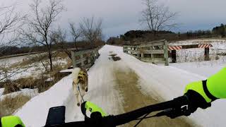
Wetlands, wildlife, sandstone bluffs, rolling croplands and pastures are just a few of the sights you can enjoy on the 400 State Trail as it repeatedly crisscrosses the Baraboo River. The entire length of the 22-mile trail follows along the river valley from Elroy to Reedsburg.

The trail is named for the Chicago-Northwestern passenger train that ran on this grade. The train traveled the 400 miles between Chicago and Minneapolis/St. Paul in 400 minutes. The renovated Reedsburg Depot is the trail headquarters and the office for the Reedsburg Chamber of Commerce. The depot is used as an information center with interpretive displays and public rest area facilities.

The 400 State Trail is directly linked to two other state trails. The Elroy-Sparta State Trail connects to the 400 State Trail at Elroy Commons on the west end. There is also a connection in Union Center to the Hillsboro State Trail.

Recent Activity on Trail

Past Week
  • 0 rides
  •  
6 Months
  • 0 rides
  •  
All
  • 1 rides
  • Last: May 30, 2026
c1c2c3c4
January
February
March
April
May
June
July
August
September
October
November
December
update trails status or condition

400 State Trail Trail Reports

statusdatedescription
Jun 21, 2021 @ 9:17am
Jun 21, 2021
more »
Status:
on Jun 21, 2021
Dry
Avg: 4.13 (2 votes)
Your vote: 0

view (53)
close
3D
Trail Conditions
  • Unknown
  • Snow Groomed
  • Snow Packed
  • Snow Covered
  • Snow Cover Partial
  • Freeze/thaw Cycle
  • Icy
  • Prevalent Mud
  • Wet
  • Variable
  • Ideal
  • Dry
  • Very Dry
Trail Flow (Ridden Direction)
Trailforks scans users ridelogs to determine the most popular direction each trail is ridden. A good flowing trail network will have most trails flowing in a single direction according to their intension.
The colour categories are based on what percentage of riders are riding a trail in its intended direction.
  • > 96%
  • > 90%
  • > 80%
  • > 70%
  • > 50%
  • < 50%
  • bi-directional trail
  • no data
Trail Last Ridden
Trailforks scans ridelogs to determine the last time a trail was ridden.
  • < 2 days
  • < 1 week
  • < 2 weeks
  • < 1 month
  • < 6 months
  • > 6 months
Trail Ridden Direction
The intended direction a trail should be ridden.
  • Downhill Only
  • Downhill Primary
  • Both Directions
  • Uphill Primary
  • Uphill Only
  • One Direction
Contribute Details
Colors indicate trail is missing specified detail.
  • Description
  • Photos
  • Description & Photos
  • Videos
Trail Popularity ?
Trailforks scans ridelogs to determine which trails are ridden the most in the last 9 months. Trails are compared with nearby trails in the same city region with a possible 25 colour shades. Think of this as a heatmap, more rides = more kinetic energy = warmer colors.
  • most popular
  • popular
  • less popular
  • not popular
ATV/ORV/OHV Filter
Max Vehicle Width
inches
US Cell Coverage
Legend
cell carrier legend

Radar Time
Activity Recordings
Trailforks uses anonymized public activity data. ?
Activity Recordings
Trailforks uses anonymized public activity data. ?
Personal Heatmap
Activity Types
all / none
Options
2
Date range month
Winter Trails
Warning A routing network for winter maps does not exist. Selecting trails using the winter trails layer has been disabled.
Missing Trails
Most Popular
Least Popular
Trails are colored based on popularity. The more popular a trail is, the more red. Less popular trails trend towards green.
Jump Magnitude Heatmap
Heatmap of where riders jump on trails. Zoom in to see individual jumps, click circles to view jump details.
BC Backroad Status

Service Road Atlas is a free to use, community-driven service for viewing and creating reports on the numerous back-country service roads around B.C. and Alberta.

map legend
Slope Aspect
Direction the slope faces
Flat N NE E SE S SW W NW
Trails Deemphasized
Trails are shown in grey.
disable
Only show trails with no bike usage.
Enable
Suggested Layers
Based on selected activity type

    Save the current map location and zoom level as your default home location whenever this page is loaded.

    Save
        Directions to 400-state-trail trailhead (43.530170, -90.008080)

        Photos

        4 more »
        69 |
        Feb 27, 2021 @ 7:17pm
        Feb 27, 2021
        64 |
        Feb 27, 2021 @ 7:17pm
        Feb 27, 2021
        39 |
        Feb 27, 2021 @ 7:17pm
        Feb 27, 2021
        45 |
        Feb 27, 2021 @ 7:17pm
        Feb 27, 2021

        Videos

        1 more »
        Messy Bikejoring part 2/
        7:08 | 164 | Feb 27, 2021 , My City

        Reviews / Comments

        No reviews yet, be the first to write a review or ask a question.
        Use trail reports to comment on trail conditions.


        We hope you've been enjoying Trailforks!

        Create a FREE account to view trail comments and much more.

        • By toddTF Pro Trailforks & contributors
        • #117390 - 2,140 views

        Frequently Asked Questions About 400 State Trail

        Where is 400 State Trail located?
        400 State Trail is located in Juneau County, Wisconsin, United States. It is part of the Juneau County trail network. The trailhead is located at coordinates 43.53017, -90.00808.
        What is the elevation gain for 400 State Trail?
        400 State Trail has 128 ft of elevation gain. The trail has 52 ft of elevation descent. The elevation ranges from 880 ft to 958 ft.
        Is 400 State Trail a point to point trail?
        400 State Trail is not a point to point trail. The direction is Both Directions. The trail type is gravel path.
        How long is 400 State Trail?
        400 State Trail is 21.9 miles long. The trail type is gravel path.

        Hit the Trail

        Open in App

        Get this trail on your phone instantly.
        open trail in app

        Download Trail

        Save to wishlist, Garmin & download.
        save the trail

        Find Related Routes

        Find routes and users activities that include this trail.
        find routes for this trail

        You must enter a description before submitting.