more stats
1.0 mile
Distance
76 ft
Climb
-830 ft
Descent
00:14:18
Avg time
-753 ft
Altitude change
3,312 ft
Altitude min
4,072 ft
Altitude max
4,065 ft
Altitude start
3,310 ft
Altitude end
-13.7%
Grade
-47.1%
Grade max
44.7%
Grade min
650 ft
Distance climb
4,557 ft
Distance down
305 ft
Distance flat
00:14:18
Avg time

5K Details

  • Activities
    • Mountain Bike
    • E-Bike
  • Riding Area
    Mount 7
    Golden, British Columbia
  • Difficulty Rating
  • Voted Difficulty
    Blue (1 vote)
  • Local Popularity
    85 in Mountain Biking [+]
    • 90 in E-Biking
  • Global Ranking
    #40065 in Mountain Biking [+]
    • #32732 in E-Biking
  • Trail Type
    Singletrack
  • Bike Type
    DH, AM
  • Direction
    Downhill Only
    Popular Direction Shown
  • Climb Difficulty
    Blue
  • Physical Rating
    Hard
  • eBike Allowed
  • TTFs on Trail
    A-Frame, Berm, Drop, Jump

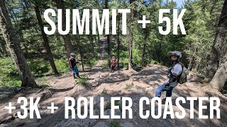
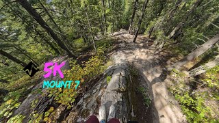
5K is a classic section of trail on the lower part of the main Mount 7 descent trail.

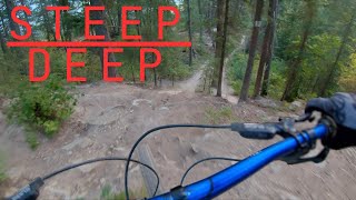
The 5K trail starts out with a short, challenging, rooty climb to the main trail. Mere mortals will give up and walk this section, how about you? When you reach the main trail, stay right and start descending. There are a couple of small punchy uphills, then the fast flow starts. The trail descends along a ridge that opens up at times with views of the valley, though you’ll probably have your eyes glued to the trail. Rooty, rocky sections of trail and corners continue on for sometime, then a section of the trail known as “Wet Dream” comes up fast. This section has a few variations that end up in the same place. The easiest and less committing option is to take the first left, which is also called the 5K Alternate, #71 on the paper map. If not taking 5K Alternate to the left, then the main line is straight ahead, and it also has a few variations to descend through a steep technical section of terrain. There are a couple of larger drops in the vicinity that are worth scouting.

After getting through the aforementioned section the trail starts descending towards the 3K/True Value entrance.

Access Info

From Reflection Lake Trailhead, one can bike or shuttle to the 5K entrance along the Bowle-Evans Road. Alternatively, one can pedal up using Schacher trail.

Local Trail Association
Traditionally Indigenous Territory

Recent Activity on Trail

Past Week
  • 5 rides
  • 11 miles average
6 Months
  • 33 rides
  • 7 miles avg distance
All
  • 362 rides
  • Last: Jun 20, 2026
c1c2c3c4
January
February
March
April
May
June
July
August
September
October
November
December
update trails status or condition

5K Trail Reports

statusdatedescription
Apr 27, 2026 @ 6:31pm (America/Edmonton)
Apr 27, 2026
reporter Wet area at the start.
Mar 30, 2026 @ 8:01pm (America/Edmonton)
Mar 30, 2026
reporter The trail crew will open trails as they are assessed. Thanks.
Aug 30, 2025 @ 1:36pm
Aug 30, 2025
Tree down
Aug 30, 2025 @ 1:35pm
Aug 30, 2025
Tree down
Jul 17, 2025 @ 11:28am
Jul 17, 2025
Drying quickly after rain.
more »
Status:
on Apr 27, 2026
Variable
Avg: 4.33 (30 votes)
Your vote: 0

view (2,295)
close
3D
Trail Conditions
  • Unknown
  • Snow Groomed
  • Snow Packed
  • Snow Covered
  • Snow Cover Partial
  • Freeze/thaw Cycle
  • Icy
  • Prevalent Mud
  • Wet
  • Variable
  • Ideal
  • Dry
  • Very Dry
Trail Flow (Ridden Direction)
Trailforks scans users ridelogs to determine the most popular direction each trail is ridden. A good flowing trail network will have most trails flowing in a single direction according to their intension.
The colour categories are based on what percentage of riders are riding a trail in its intended direction.
  • > 96%
  • > 90%
  • > 80%
  • > 70%
  • > 50%
  • < 50%
  • bi-directional trail
  • no data
Trail Last Ridden
Trailforks scans ridelogs to determine the last time a trail was ridden.
  • < 2 days
  • < 1 week
  • < 2 weeks
  • < 1 month
  • < 6 months
  • > 6 months
Trail Ridden Direction
The intended direction a trail should be ridden.
  • Downhill Only
  • Downhill Primary
  • Both Directions
  • Uphill Primary
  • Uphill Only
  • One Direction
Contribute Details
Colors indicate trail is missing specified detail.
  • Description
  • Photos
  • Description & Photos
  • Videos
Trail Popularity ?
Trailforks scans ridelogs to determine which trails are ridden the most in the last 9 months. Trails are compared with nearby trails in the same city region with a possible 25 colour shades. Think of this as a heatmap, more rides = more kinetic energy = warmer colors.
  • most popular
  • popular
  • less popular
  • not popular
ATV/ORV/OHV Filter
Max Vehicle Width
inches
US Cell Coverage
Legend
cell carrier legend

Radar Time
Activity Recordings
Trailforks uses anonymized public activity data. ?
Activity Recordings
Trailforks uses anonymized public activity data. ?
Personal Heatmap
Activity Types
all / none
Options
2
Date range month
Winter Trails
Warning A routing network for winter maps does not exist. Selecting trails using the winter trails layer has been disabled.
Missing Trails
Most Popular
Least Popular
Trails are colored based on popularity. The more popular a trail is, the more red. Less popular trails trend towards green.
Jump Magnitude Heatmap
Heatmap of where riders jump on trails. Zoom in to see individual jumps, click circles to view jump details.
BC Backroad Status

Service Road Atlas is a free to use, community-driven service for viewing and creating reports on the numerous back-country service roads around B.C. and Alberta.

map legend
Slope Aspect
Direction the slope faces
Flat N NE E SE S SW W NW
Trails Deemphasized
Trails are shown in grey.
disable
Only show trails with no bike usage.
Enable
Suggested Layers
Based on selected activity type

    Save the current map location and zoom level as your default home location whenever this page is loaded.

    Save
        Directions to 5k-3461 trailhead (51.278770, -116.911540)

        Photos

        16 more »
        875 |
        Sep 6, 2011 @ 10:11pm
        Sep 6, 2011
        683 |
        Dec 9, 2008 @ 6:03pm
        Dec 9, 2008
        91 |
        Oct 6, 2023 @ 7:18pm
        Oct 6, 2023
        87 |
        Oct 6, 2023 @ 7:18pm
        Oct 6, 2023

        Videos

        13 more »
        Summit + 5K + 3K True Value + Roller Coaster |...
        27:50 | 77 | Oct 23, 2025 , Golden
        youtuber SUNSET ride at MOUNT 7
        20:09 | 125 | Apr 28, 2025 , Golden
        5K - Mount 7
        10:53 | 139 | Apr 6, 2025 , Golden
        Summit, Moonshine, Skid Marks and 5 km
        10:54 | 397 | Oct 16, 2021 , Golden

        Routes with this trail

        8 miles 1,727 ft 11 Race
        This is the 2025 Gals Enduro Equinox fall event

        1 Review & Comments


        We hope you've been enjoying Trailforks!

        Create a FREE account to view trail comments and much more.

        Nearby Trails

        • By canadakaTF Pro Trailforks & contributors
        • #3461 - 7,174 views

        Frequently Asked Questions About 5K

        Where is 5K located?
        5K is located in Mount 7, Golden, British Columbia, Canada. It is part of the Mount 7 trail network. The trailhead is located at coordinates 51.27877, -116.91154.
        How hard is 5K?
        5K is rated as Black Diamond difficulty. The physical rating is Hard. The average grade is 13.7%. The climb difficulty is rated Blue.
        What is the elevation gain for 5K?
        5K has 76 ft of elevation gain. The trail has 830 ft of elevation descent. The elevation ranges from 3,312 ft to 4,072 ft.
        Is 5K a point to point trail?
        Yes, 5K is a point to point trail. The direction is Downhill Only. The trail type is singletrack.

        Hit the Trail

        Open in App

        Get this trail on your phone instantly.
        open trail in app

        Download Trail

        Save to wishlist, Garmin & download.
        save the trail

        Find Related Routes

        Find routes and users activities that include this trail.
        find routes for this trail

        You must enter a description before submitting.