This trail is permanently closed/decommissioned
more stats
1,191 ft
Distance
-128 ft
Descent
00:01:29
Avg time
-128 ft
Altitude change
1,320 ft
Altitude min
1,449 ft
Altitude max
1,449 ft
Altitude start
1,322 ft
Altitude end
-10.7%
Grade
-192.6%
Grade max
3.6%
Grade min
20 ft
Distance climb
1,129 ft
Distance down
43 ft
Distance flat
00:01:29
Avg time

50:01 Details

  • Activities
    • Mountain Bike
  • Riding Area
  • Difficulty Rating
  • Voted Difficulty
    Proline (1 vote)
  • Local Popularity
    30 in Mountain Biking
  • Trail Type
    Machine Groomed
  • Bike Type
    DH, AM, DJ
  • Direction
    Downhill Only
    Popular Direction Shown
  • Physical Rating
    Extreme
  • Dogs Allowed
    Yes
  • eBike Allowed
  • TTFs on Trail
    Berm, Drop, Jump, Gap Jump, Other
  • Ride in Rain
    Yes
  • Year Opened
    2016
  • Land Owner
    James Foster

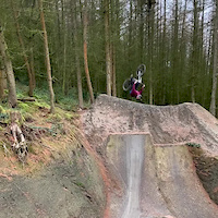
A collaboration between Revolution Bike Park and the legendary 50:01 guys, Steve Peat, Josh Bryceland, Sam Dale, Loosedog Lewis and Craig Evans to name but a few, this track ain't for the faint hearted Some of the biggest jumps and gaps around, multiple options with gaps as big as 30 feet plus, there's airtime for days. This track is for a highly skilled level of rider.

Access Info

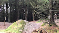
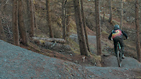
Start at the wooden roll in for the freeride, then after about 30m the first jump is on the left.

Disclaimer

*LARGE MANDATORY GAP JUMPS, EXTREME RISK*

Bike Park

Recent Activity on Trail

Past Week
  • 0 rides
  •  
6 Months
  • 0 rides
  •  
All
  • 2 rides
  • Last: Dec 5, 2025
c1c2c3c4
January
February
March
April
May
June
July
August
September
October
November
December
update trails status or condition

50:01 Trail Reports

no reports have been added for 50:01 yet, add a trail report.
Trail reports are used to indicate a trails current condition and inform builders and other riders about any issues on a trail.
Status:
Avg: 4.16 (6 votes)
Your vote: 0

view (493)
close
3D
Trail Conditions
  • Unknown
  • Snow Groomed
  • Snow Packed
  • Snow Covered
  • Snow Cover Partial
  • Freeze/thaw Cycle
  • Icy
  • Prevalent Mud
  • Wet
  • Variable
  • Ideal
  • Dry
  • Very Dry
Trail Flow (Ridden Direction)
Trailforks scans users ridelogs to determine the most popular direction each trail is ridden. A good flowing trail network will have most trails flowing in a single direction according to their intension.
The colour categories are based on what percentage of riders are riding a trail in its intended direction.
  • > 96%
  • > 90%
  • > 80%
  • > 70%
  • > 50%
  • < 50%
  • bi-directional trail
  • no data
Trail Last Ridden
Trailforks scans ridelogs to determine the last time a trail was ridden.
  • < 2 days
  • < 1 week
  • < 2 weeks
  • < 1 month
  • < 6 months
  • > 6 months
Trail Ridden Direction
The intended direction a trail should be ridden.
  • Downhill Only
  • Downhill Primary
  • Both Directions
  • Uphill Primary
  • Uphill Only
  • One Direction
Contribute Details
Colors indicate trail is missing specified detail.
  • Description
  • Photos
  • Description & Photos
  • Videos
Trail Popularity ?
Trailforks scans ridelogs to determine which trails are ridden the most in the last 9 months. Trails are compared with nearby trails in the same city region with a possible 25 colour shades. Think of this as a heatmap, more rides = more kinetic energy = warmer colors.
  • most popular
  • popular
  • less popular
  • not popular
ATV/ORV/OHV Filter
Max Vehicle Width
inches
US Cell Coverage
Legend
cell carrier legend

Radar Time
Activity Recordings
Trailforks uses anonymized public activity data. ?
Activity Recordings
Trailforks uses anonymized public activity data. ?
Personal Heatmap
Activity Types
all / none
Options
2
Date range month
Winter Trails
Warning A routing network for winter maps does not exist. Selecting trails using the winter trails layer has been disabled.
Missing Trails
Most Popular
Least Popular
Trails are colored based on popularity. The more popular a trail is, the more red. Less popular trails trend towards green.
Jump Magnitude Heatmap
Heatmap of where riders jump on trails. Zoom in to see individual jumps, click circles to view jump details.
BC Backroad Status

Service Road Atlas is a free to use, community-driven service for viewing and creating reports on the numerous back-country service roads around B.C. and Alberta.

map legend
Slope Aspect
Direction the slope faces
Flat N NE E SE S SW W NW
Trails Deemphasized
Trails are shown in grey.
disable
Only show trails with no bike usage.
Enable
Suggested Layers
Based on selected activity type

    Save the current map location and zoom level as your default home location whenever this page is loaded.

    Save
        Directions to 50-01 trailhead (52.810310, -3.412010)

        Photos

        10 more »
        185 |
        Dec 13, 2022 @ 3:29am
        Dec 13, 2022
        235 |
        Sep 30, 2019 @ 10:19am
        Sep 30, 2019
        119 |
        May 1, 2019 @ 1:27pm
        May 1, 2019
        143 |
        May 1, 2019 @ 1:27pm
        May 1, 2019

        Videos

        4 more »
        Vision line Sends - Charlie Flynn
        0:54 | 209 | Jan 5, 2020 , Llangynog
        Charlie Flynn X Revolution Bike Park
        2:20 | 154 | Dec 12, 2019 , Llangynog
        50to1 full send
        0:05 | 1036 | Nov 5, 2018 , Llangynog
        Kenevo at Revolution Bike Park
        0:46 | 8325 | May 22, 2018 , Llangynog

        Reviews / Comments

        No reviews yet, be the first to write a review or ask a question.
        Use trail reports to comment on trail conditions.


        We hope you've been enjoying Trailforks!

        Create a FREE account to view trail comments and much more.

        • By joegermains & contributors
        • #112722 - 2,731 views

        Frequently Asked Questions About 50:01

        Where is 50:01 located?
        50:01 is located in Revolution Bikepark, Llangynog, United Kingdom. It is part of the Revolution Bikepark trail network. The trailhead is located at coordinates 52.81031, -3.41201.
        How hard is 50:01?
        50:01 is rated as Proline difficulty. The physical rating is Extreme. The average grade is 10.7%.
        What is the elevation gain for 50:01?
        The trail has 128 ft of elevation descent. The elevation ranges from 1,320 ft to 1,449 ft.
        Is 50:01 a point to point trail?
        Yes, 50:01 is a point to point trail. The direction is Downhill Only. The trail type is machine groomed.

        Hit the Trail

        Open in App

        Get this trail on your phone instantly.
        open trail in app

        Download Trail

        Save to wishlist, Garmin & download.
        save the trail

        Find Related Routes

        Find routes and users activities that include this trail.
        find routes for this trail

        You must enter a description before submitting.