more stats
5,010 ft
Distance
3 ft
Climb
-1,142 ft
Descent
00:11:44
Avg time
-1,139 ft
Altitude change
5,454 ft
Altitude min
6,594 ft
Altitude max
6,594 ft
Altitude start
5,456 ft
Altitude end
-22.7%
Grade
-77.1%
Grade max
3.3%
Grade min
39 ft
Distance climb
4,934 ft
Distance down
36 ft
Distance flat
00:11:44
Avg time

72 Corbes Details

  • Activities
    • Mountain Bike
    • E-Bike
  • Riding Area
  • Difficulty Rating
  • Local Popularity
    70 in Mountain Biking [+]
    • 70 in E-Biking
  • Global Ranking
    #180784 in Mountain Biking [+]
    • #49549 in E-Biking
  • Trail Type
    Singletrack
  • Bike Type
    DH, AM
  • Direction
    Downhill Only[+]
    Popular Direction Shown
    • Downhill Only for E-Biking
  • Physical Rating
    Hard
  • Trail Visibility
    Always easy to follow
  • eBike Allowed
    Yes up to Class 1

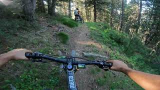
Baixada més aviat estreta amb moltes curves tancades i algun petit pas tècnic. Si està seca seria una vermella + però si està molla és clarament una negra. No fer-la amb bici de dh ja que costarà girar en algunes curves i la tornada fins soldeu és durilla.

Bike Park

Recent Activity on Trail

Past Week
  • 0 rides
  •  
6 Months
  • 0 rides
  •  
All
  • 12 rides
  • Last: May 31, 2026
c1c2c3c4
January
February
March
April
May
June
July
August
September
October
November
December
update trails status or condition

72 Corbes Trail Reports

statusdatedescription
Jun 1, 2026 @ 9:24am (Europe/Andorra)
Jun 1, 2026
seulement un arbre en travers, mais qui se contourne facilement
May 31, 2026 @ 9:56am (Europe/Andorra)
May 31, 2026
fabuleux single naturel
Sep 7, 2025 @ 12:14pm
Sep 7, 2025
En general en bon estat. Trail natural.
Jul 22, 2024 @ 9:23am
Jul 22, 2024
Jun 16, 2024 @ 5:19am
Jun 16, 2024
Para gozarla, increíble bajada sin descanso.
more »
Status:
on Jun 1, 2026
Ideal
Avg: 3.89 (4 votes)
Your vote: 0

view (93)
close
3D
Trail Conditions
  • Unknown
  • Snow Groomed
  • Snow Packed
  • Snow Covered
  • Snow Cover Partial
  • Freeze/thaw Cycle
  • Icy
  • Prevalent Mud
  • Wet
  • Variable
  • Ideal
  • Dry
  • Very Dry
Trail Flow (Ridden Direction)
Trailforks scans users ridelogs to determine the most popular direction each trail is ridden. A good flowing trail network will have most trails flowing in a single direction according to their intension.
The colour categories are based on what percentage of riders are riding a trail in its intended direction.
  • > 96%
  • > 90%
  • > 80%
  • > 70%
  • > 50%
  • < 50%
  • bi-directional trail
  • no data
Trail Last Ridden
Trailforks scans ridelogs to determine the last time a trail was ridden.
  • < 2 days
  • < 1 week
  • < 2 weeks
  • < 1 month
  • < 6 months
  • > 6 months
Trail Ridden Direction
The intended direction a trail should be ridden.
  • Downhill Only
  • Downhill Primary
  • Both Directions
  • Uphill Primary
  • Uphill Only
  • One Direction
Contribute Details
Colors indicate trail is missing specified detail.
  • Description
  • Photos
  • Description & Photos
  • Videos
Trail Popularity ?
Trailforks scans ridelogs to determine which trails are ridden the most in the last 9 months. Trails are compared with nearby trails in the same city region with a possible 25 colour shades. Think of this as a heatmap, more rides = more kinetic energy = warmer colors.
  • most popular
  • popular
  • less popular
  • not popular
ATV/ORV/OHV Filter
Max Vehicle Width
inches
US Cell Coverage
Legend
cell carrier legend

Radar Time
Activity Recordings
Trailforks uses anonymized public activity data. ?
Activity Recordings
Trailforks uses anonymized public activity data. ?
Personal Heatmap
Activity Types
all / none
Options
2
Date range month
Winter Trails
Warning A routing network for winter maps does not exist. Selecting trails using the winter trails layer has been disabled.
Missing Trails
Most Popular
Least Popular
Trails are colored based on popularity. The more popular a trail is, the more red. Less popular trails trend towards green.
Jump Magnitude Heatmap
Heatmap of where riders jump on trails. Zoom in to see individual jumps, click circles to view jump details.
BC Backroad Status

Service Road Atlas is a free to use, community-driven service for viewing and creating reports on the numerous back-country service roads around B.C. and Alberta.

map legend
Slope Aspect
Direction the slope faces
Flat N NE E SE S SW W NW
Trails Deemphasized
Trails are shown in grey.
disable
Only show trails with no bike usage.
Enable
Suggested Layers
Based on selected activity type

    Save the current map location and zoom level as your default home location whenever this page is loaded.

    Save
        Directions to 72-corbes-280742 trailhead (42.570410, 1.638570)

        Photos

        No photos have been added for 72 Corbes yet, add a photo.

        Videos

        1 more »
        Grandvalira E-Bikes Trails | 72 Corbes | Andorra
        8:39 | 54 | May 9, 2026 , My City

        1 Review & Comments


        We hope you've been enjoying Trailforks!

        Create a FREE account to view trail comments and much more.

        • By snaker4TF Pro TFSPAIN & contributors
        • #280742 - 854 views

        Frequently Asked Questions About 72 Corbes

        Where is 72 Corbes located?
        72 Corbes is located in Grandvalira E-Bikes Trails, Andorra. It is part of the Grandvalira E-Bikes Trails trail network. The trailhead is located at coordinates 42.57041, 1.63857.
        How hard is 72 Corbes?
        72 Corbes is rated as Black difficulty. The physical rating is Hard. The average grade is 22.7%.
        What is the elevation gain for 72 Corbes?
        72 Corbes has 3 ft of elevation gain. The trail has 1,142 ft of elevation descent. The elevation ranges from 5,454 ft to 6,594 ft.
        Is 72 Corbes a point to point trail?
        Yes, 72 Corbes is a point to point trail. The direction is Downhill Only. The trail type is singletrack.

        Hit the Trail

        Open in App

        Get this trail on your phone instantly.
        open trail in app

        Download Trail

        Save to wishlist, Garmin & download.
        save the trail

        Find Related Routes

        Find routes and users activities that include this trail.
        find routes for this trail

        You must enter a description before submitting.