more stats
1.1 miles
Distance
-684 ft
Descent
00:09:59
Avg time
-684 ft
Altitude change
4,817 ft
Altitude min
5,501 ft
Altitude max
5,501 ft
Altitude start
4,816 ft
Altitude end
-11.5%
Grade
-45%
Grade max
1 mile
Distance down
220 ft
Distance flat
00:09:59
Avg time

8volante High Details

  • Activities
    • Mountain Bike
  • Riding Area
  • Difficulty Rating
  • Local Popularity
    55 in Mountain Biking
  • Global Ranking
    #47760 in Mountain Biking
  • Trail Type
    Machine Groomed
  • Bike Type
    DH, AM, XC
  • Trail Visibility
    Always easy to follow
  • Dogs Allowed
    Yes
  • TTFs on Trail
    Bridge, Drop, Jump, Roller Coaster
  • Year Opened
    2016
  • Land Owner

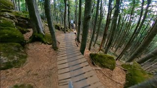
✦ Trovate il vostro flow ✦

Trail molto fluido e veloce ricco di appoggi, paraboliche e piccoli salti. Per questa sua caratteristica è adatto sia per i principianti, sia per gli esperti che vogliono osare con salti realizzati a doppia variante verde e blu.

----------------------

✦ Find your flow ✦

Trail very fluid and fast, full of berms and small jumps. Because of this characteristic it is suitable both for beginners and for experts who want to dare with jumps made of a double green and blue variant.

Trail Supporters

Bike Park

Local Trail Association

Recent Activity on Trail

Past Week
  • 5 rides
  • 17 miles average
6 Months
  • 12 rides
  • 17 miles avg distance
All
  • 151 rides
  • Last: Jun 18, 2026
c1c2c3c4
January
February
March
April
May
June
July
August
September
October
November
December
Status:
on Jun 6, 2026
Ideal
Avg: 4.54 (20 votes)
Your vote: 0

view (3,887)
close
3D
Trail Conditions
  • Unknown
  • Snow Groomed
  • Snow Packed
  • Snow Covered
  • Snow Cover Partial
  • Freeze/thaw Cycle
  • Icy
  • Prevalent Mud
  • Wet
  • Variable
  • Ideal
  • Dry
  • Very Dry
Trail Flow (Ridden Direction)
Trailforks scans users ridelogs to determine the most popular direction each trail is ridden. A good flowing trail network will have most trails flowing in a single direction according to their intension.
The colour categories are based on what percentage of riders are riding a trail in its intended direction.
  • > 96%
  • > 90%
  • > 80%
  • > 70%
  • > 50%
  • < 50%
  • bi-directional trail
  • no data
Trail Last Ridden
Trailforks scans ridelogs to determine the last time a trail was ridden.
  • < 2 days
  • < 1 week
  • < 2 weeks
  • < 1 month
  • < 6 months
  • > 6 months
Trail Ridden Direction
The intended direction a trail should be ridden.
  • Downhill Only
  • Downhill Primary
  • Both Directions
  • Uphill Primary
  • Uphill Only
  • One Direction
Contribute Details
Colors indicate trail is missing specified detail.
  • Description
  • Photos
  • Description & Photos
  • Videos
Trail Popularity ?
Trailforks scans ridelogs to determine which trails are ridden the most in the last 9 months. Trails are compared with nearby trails in the same city region with a possible 25 colour shades. Think of this as a heatmap, more rides = more kinetic energy = warmer colors.
  • most popular
  • popular
  • less popular
  • not popular
ATV/ORV/OHV Filter
Max Vehicle Width
inches
US Cell Coverage
Legend
cell carrier legend

Radar Time
Activity Recordings
Trailforks uses anonymized public activity data. ?
Activity Recordings
Trailforks uses anonymized public activity data. ?
Personal Heatmap
Activity Types
all / none
Options
2
Date range month
Winter Trails
Warning A routing network for winter maps does not exist. Selecting trails using the winter trails layer has been disabled.
Missing Trails
Most Popular
Least Popular
Trails are colored based on popularity. The more popular a trail is, the more red. Less popular trails trend towards green.
Jump Magnitude Heatmap
Heatmap of where riders jump on trails. Zoom in to see individual jumps, click circles to view jump details.
BC Backroad Status

Service Road Atlas is a free to use, community-driven service for viewing and creating reports on the numerous back-country service roads around B.C. and Alberta.

map legend
Slope Aspect
Direction the slope faces
Flat N NE E SE S SW W NW
Trails Deemphasized
Trails are shown in grey.
disable
Only show trails with no bike usage.
Enable
Suggested Layers
Based on selected activity type

    Save the current map location and zoom level as your default home location whenever this page is loaded.

    Save
        Directions to 8volante-high trailhead (42.887530, 11.620580)

        Photos

        8 more »
        185 |
        Mar 26, 2022 @ 2:43am
        Mar 26, 2022
        152 |
        Mar 26, 2022 @ 2:43am
        Mar 26, 2022
        147 |
        Mar 26, 2022 @ 2:42am
        Mar 26, 2022
        151 |
        Mar 26, 2022 @ 2:41am
        Mar 26, 2022

        Videos

        12 more »
        featured Amiata Freeride Bike Resort
        2:12 | 248 | Feb 18, 2019 , Monte Amiata
        youtuber Ottovolante + Area Jump - Amiata Freeride Bike...
        7:01 | 185 | Aug 15, 2024 , Monte Amiata
        youtuber MTB Amiata Freeride 22.07.2023 sentieri...
        7:13 | 173 | Jul 23, 2023 , Monte Amiata
        youtuber MTB Amiata Freeride 22.07.2023 sentieri...
        7:34 | 312 | Aug 3, 2023 , Monte Amiata

        1 Review & Comments


        We hope you've been enjoying Trailforks!

        Create a FREE account to view trail comments and much more.

        • By amiatafreeride AMFR & contributors
        • #116782 - 7,072 views

        Frequently Asked Questions About 8volante High

        Where is 8volante High located?
        8volante High is located in Amiata Freeride Bike Resort, Monte Amiata, Italy. It is part of the Amiata Freeride Bike Resort trail network. The trailhead is located at coordinates 42.88753, 11.62058.
        How hard is 8volante High?
        8volante High is rated as Green difficulty. The average grade is 11.5%.
        What is the elevation gain for 8volante High?
        The trail has 208 m of elevation descent. The elevation ranges from 1,468 m to 1,677 m.
        How long is 8volante High?
        8volante High is 1.8 km long. The trail type is machine groomed.

        Hit the Trail

        Open in App

        Get this trail on your phone instantly.
        open trail in app

        Download Trail

        Save to wishlist, Garmin & download.
        save the trail

        Find Related Routes

        Find routes and users activities that include this trail.
        find routes for this trail

        You must enter a description before submitting.