


Open in App
Get this trail on your phone instantly.

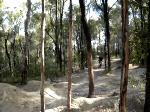
Follow on track from "V". Narrow dirt track in trees. Has two sections, first ends with an off camber roll down onto a walking track, second starts straight across that track with a little chute and ends in the same place as lower TTS. Both sections, especially the lower one are trickier when wet, or when very dry and dusty. Most of this track is intermediate level (Grade 3) but the end of the first section and start of the second one are advanced. (Grade 4)
Generally ridden from the end of V. Turn left (South), passing one walking track intersection dropping to the right. The start of A is 20 meters up the hill, starting on the right. It's not signposted. Or, from Pirie St Park, right up to the top of the steps and then take main walking track the track heading up to the left. Where this track ends, you're almost at the end of V, turn hard right and "A" is 20 meters uphill on your right.
| c1 | c2 | c3 | c4 |
|---|---|---|---|
January | February | March | April |
May | June | July | August |
September | October | November | December |

Service Road Atlas is a free to use, community-driven service for viewing and creating reports on the numerous back-country service roads around B.C. and Alberta.
Save the current map location and zoom level as your default home location whenever this page is loaded.
SaveWe hope you've been enjoying Trailforks!
Create a FREE account to view trail comments and much more.
You must enter a description before submitting.

