more stats
1,532 ft
Distance
5 ft
Climb
-320 ft
Descent
00:03:37
Avg time
-315 ft
Altitude change
71 ft
Altitude min
386 ft
Altitude max
386 ft
Altitude start
71 ft
Altitude end
-20.584%
Grade
-48.716%
Grade max
3.05%
Grade min
147 ft
Distance climb
1,363 ft
Distance down
22 ft
Distance flat
00:03:37
Avg time

A Game Details

  • Activities
    • Mountain Bike
    • Hike
    • Trail Running
  • Riding Area
  • AKA
    Path to Kilmuir Shore
  • Difficulty Rating
  • Local Popularity
    20 in Mountain Biking [+]
    • 5 in Trail Running
    • 5 in Hiking
  • Global Ranking
    #259519 in Mountain Biking [+]
    • #141339 in Trail Running
    • #135719 in Hiking
  • Trail Type
    Singletrack
  • Bike Type
    AM
  • Direction
    Downhill Primary
    Popular Direction Shown
  • Physical Rating
    Moderate
  • Dogs Allowed
    Yes
  • TTFs on Trail
    Berm, Drop, Jump
  • Ride in Rain
    Yes
  • Year Opened
    2015
  • Land Owner
    Forestry Commission

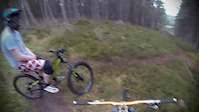
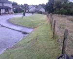
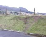
Steep descent to link Ord Hill to Kilmuir. Starts of with steep berms and then joins on to walkers path with steep slippery steps to sea. Ride along shore front to Kilmuir (good view to Inverness).

Access Info

Trail branches off from Ord Hill's middle fireroad.

This trail is unsanctioned.

Disclaimer

Not well used so watch out for branches on trail

Recent Activity on Trail

Past Week
  • 0 rides
  •  
6 Months
  • 0 rides
  •  
All
  • 4 rides
  • Last: Nov 5, 2025
c1c2c3c4
January
February
March
April
May
June
July
August
September
October
November
December
update trails status or condition

A Game Trail Reports

no reports have been added for A Game yet, add a trail report.
Trail reports are used to indicate a trails current condition and inform builders and other riders about any issues on a trail.
Status:
no votes yet
Your vote: 0

view (16)
close
3D
Trail Conditions
  • Unknown
  • Snow Groomed
  • Snow Packed
  • Snow Covered
  • Snow Cover Partial
  • Freeze/thaw Cycle
  • Icy
  • Prevalent Mud
  • Wet
  • Variable
  • Ideal
  • Dry
  • Very Dry
Trail Flow (Ridden Direction)
Trailforks scans users ridelogs to determine the most popular direction each trail is ridden. A good flowing trail network will have most trails flowing in a single direction according to their intension.
The colour categories are based on what percentage of riders are riding a trail in its intended direction.
  • > 96%
  • > 90%
  • > 80%
  • > 70%
  • > 50%
  • < 50%
  • bi-directional trail
  • no data
Trail Last Ridden
Trailforks scans ridelogs to determine the last time a trail was ridden.
  • < 2 days
  • < 1 week
  • < 2 weeks
  • < 1 month
  • < 6 months
  • > 6 months
Trail Ridden Direction
The intended direction a trail should be ridden.
  • Downhill Only
  • Downhill Primary
  • Both Directions
  • Uphill Primary
  • Uphill Only
  • One Direction
Contribute Details
Colors indicate trail is missing specified detail.
  • Description
  • Photos
  • Description & Photos
  • Videos
Trail Popularity ?
Trailforks scans ridelogs to determine which trails are ridden the most in the last 9 months. Trails are compared with nearby trails in the same city region with a possible 25 colour shades. Think of this as a heatmap, more rides = more kinetic energy = warmer colors.
  • most popular
  • popular
  • less popular
  • not popular
ATV/ORV/OHV Filter
Max Vehicle Width
inches
US Cell Coverage
Legend
cell carrier legend

Radar Time
Activity Recordings
Trailforks uses anonymized public activity data. ?
Activity Recordings
Trailforks uses anonymized public activity data. ?
Personal Heatmap
Activity Types
all / none
Options
2
Date range month
Winter Trails
Warning A routing network for winter maps does not exist. Selecting trails using the winter trails layer has been disabled.
Missing Trails
Most Popular
Least Popular
Trails are colored based on popularity. The more popular a trail is, the more red. Less popular trails trend towards green.
Jump Magnitude Heatmap
Heatmap of where riders jump on trails. Zoom in to see individual jumps, click circles to view jump details.
BC Backroad Status

Service Road Atlas is a free to use, community-driven service for viewing and creating reports on the numerous back-country service roads around B.C. and Alberta.

map legend
Slope Aspect
Direction the slope faces
Flat N NE E SE S SW W NW
Trails Deemphasized
Trails are shown in grey.
disable
Only show trails with no bike usage.
Enable
Suggested Layers
Based on selected activity type

    Save the current map location and zoom level as your default home location whenever this page is loaded.

    Save
        Directions to a-game trailhead (57.511810, -4.228920)

        Photos

        No photos have been added for A Game yet, add a photo.

        Videos

        6 more »
        Game Of Chase
        2:03 | 1058 | Dec 14, 2013 , Inverness
        HAHAHHAHAHAHAHAHHA
        0:12 | 216 | Dec 5, 2011 , Inverness
        abubaca
        0:04 | 317 | Aug 7, 2008 , Inverness
        abubaca
        0:05 | 253 | Aug 7, 2008 , Inverness

        Reviews / Comments

        No reviews yet, be the first to write a review or ask a question.
        Use trail reports to comment on trail conditions.


        We hope you've been enjoying Trailforks!

        Create a FREE account to view trail comments and much more.

        • #103474 - 1,360 views

        Frequently Asked Questions About A Game

        Where is A Game located?
        A Game is located in Ord Hill and Kilmuir Hill, Inverness, United Kingdom. It is part of the Ord Hill and Kilmuir Hill trail network. The trailhead is located at coordinates 57.51181, -4.22892.
        How hard is A Game?
        A Game is rated as Black difficulty. The physical rating is Moderate. The average grade is 20.584%.
        What is the elevation gain for A Game?
        A Game has 5 ft of elevation gain. The trail has 320 ft of elevation descent. The elevation ranges from 71 ft to 386 ft.
        Is A Game a point to point trail?
        A Game is not a point to point trail. The direction is Downhill Primary. The trail type is singletrack.

        Hit the Trail

        Open in App

        Get this trail on your phone instantly.
        open trail in app

        Download Trail

        Save to wishlist, Garmin & download.
        save the trail

        Find Related Routes

        Find routes and users activities that include this trail.
        find routes for this trail

        You must enter a description before submitting.