more stats
2,297 ft
Distance
-250 ft
Descent
00:22:55
Avg time
-250 ft
Altitude change
505 ft
Altitude min
756 ft
Altitude max
756 ft
Altitude start
505 ft
Altitude end
-10.9%
Grade
-38.1%
Grade max
2,073 ft
Distance down
223 ft
Distance flat
00:22:55
Avg time

Abba Zabba Details

  • Activities
    • Mountain Bike
    • Gravel Bike
  • Riding Area
    Surrey Hills
    Dorking
  • AKA
    Whitedown
  • Difficulty Rating
  • Voted Difficulty
    Blue (5 votes)
  • Local Popularity
    25 in Mountain Biking
  • Global Ranking
    #66385 in Mountain Biking
  • Trail Type
    Singletrack
  • Bike Type
    AM, Adaptive MTB, Gravel
  • Direction
    Downhill Only
  • Climb Difficulty
    Green
  • Physical Rating
    Easy
  • Season
    May-Sept
  • Dogs Allowed
    Yes
  • eBike Allowed
    Yes up to Class 1
  • TTFs on Trail
    Jump, Roller Coaster

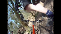
A series of big bomb-holes and significant, but straight, roll-ins, along with a road crossing. Mainly chalk / flint trail surface so very slippery when damp. Choice of several lines so most riders should be able to complete the run, if not all of the features.

This trail is unsanctioned.

Recent Activity on Trail

Past Week
  • 0 rides
  •  
6 Months
  • 4 rides
  • 18 miles avg distance
All
  • 21 rides
  • Last: Jun 14, 2026
c1c2c3c4
January
February
March
April
May
June
July
August
September
October
November
December
update trails status or condition

Abba Zabba Trail Reports

statusdatedescription
Aug 18, 2024 @ 9:18am
Aug 18, 2024
Sep 30, 2023 @ 9:40am
Sep 30, 2023
Several trees down after the first big drop in. Difficult to get round. Take the chicken line around instead
Jul 19, 2022 @ 6:15am
Jul 19, 2022
reporter Large tree down across trail, blocking trail 2/3 way down, a detour round is becoming established but not yet bedded in. New entrance / line...
Jul 18, 2021 @ 12:08am
Jul 18, 2021
Nice lines and rollers
Feb 27, 2021 @ 1:45am
Feb 27, 2021
Forestry work and felled timber blocking entrance to trail
more »
Status:
on Aug 18, 2024
Dry
Avg: 4.07 (7 votes)
Your vote: 0

view (351)
close
3D
Trail Conditions
  • Unknown
  • Snow Groomed
  • Snow Packed
  • Snow Covered
  • Snow Cover Partial
  • Freeze/thaw Cycle
  • Icy
  • Prevalent Mud
  • Wet
  • Variable
  • Ideal
  • Dry
  • Very Dry
Trail Flow (Ridden Direction)
Trailforks scans users ridelogs to determine the most popular direction each trail is ridden. A good flowing trail network will have most trails flowing in a single direction according to their intension.
The colour categories are based on what percentage of riders are riding a trail in its intended direction.
  • > 96%
  • > 90%
  • > 80%
  • > 70%
  • > 50%
  • < 50%
  • bi-directional trail
  • no data
Trail Last Ridden
Trailforks scans ridelogs to determine the last time a trail was ridden.
  • < 2 days
  • < 1 week
  • < 2 weeks
  • < 1 month
  • < 6 months
  • > 6 months
Trail Ridden Direction
The intended direction a trail should be ridden.
  • Downhill Only
  • Downhill Primary
  • Both Directions
  • Uphill Primary
  • Uphill Only
  • One Direction
Contribute Details
Colors indicate trail is missing specified detail.
  • Description
  • Photos
  • Description & Photos
  • Videos
Trail Popularity ?
Trailforks scans ridelogs to determine which trails are ridden the most in the last 9 months. Trails are compared with nearby trails in the same city region with a possible 25 colour shades. Think of this as a heatmap, more rides = more kinetic energy = warmer colors.
  • most popular
  • popular
  • less popular
  • not popular
ATV/ORV/OHV Filter
Max Vehicle Width
inches
US Cell Coverage
Legend
cell carrier legend

Radar Time
Activity Recordings
Trailforks uses anonymized public activity data. ?
Activity Recordings
Trailforks uses anonymized public activity data. ?
Personal Heatmap
Activity Types
all / none
Options
2
Date range month
Winter Trails
Warning A routing network for winter maps does not exist. Selecting trails using the winter trails layer has been disabled.
Missing Trails
Most Popular
Least Popular
Trails are colored based on popularity. The more popular a trail is, the more red. Less popular trails trend towards green.
Jump Magnitude Heatmap
Heatmap of where riders jump on trails. Zoom in to see individual jumps, click circles to view jump details.
BC Backroad Status

Service Road Atlas is a free to use, community-driven service for viewing and creating reports on the numerous back-country service roads around B.C. and Alberta.

map legend
Slope Aspect
Direction the slope faces
Flat N NE E SE S SW W NW
Trails Deemphasized
Trails are shown in grey.
disable
Only show trails with no bike usage.
Enable
Suggested Layers
Based on selected activity type

    Save the current map location and zoom level as your default home location whenever this page is loaded.

    Save
        Directions to abba-zabba trailhead (51.229100, -0.407090)

        Photos

        3 more »
        90 |
        Jan 18, 2023 @ 8:53am
        Jan 18, 2023
        1,133 |
        May 29, 2011 @ 12:18am
        May 29, 2011
        961 |
        May 29, 2011 @ 12:19am
        May 29, 2011

        Videos

        1 more »
        Chase The Sun
        4:52 | 1250 | Feb 2, 2017 , Dorking

        4 Reviews & Comments


        We hope you've been enjoying Trailforks!

        Create a FREE account to view trail comments and much more.

        • #34247 - 5,265 views

        Frequently Asked Questions About Abba Zabba

        Where is Abba Zabba located?
        Abba Zabba is located in Surrey Hills, Dorking, United Kingdom. It is part of the Surrey Hills trail network. The trailhead is located at coordinates 51.2291, -0.40709.
        What is the elevation gain for Abba Zabba?
        The trail has 250 ft of elevation descent. The elevation ranges from 505 ft to 756 ft.
        Is Abba Zabba a point to point trail?
        Yes, Abba Zabba is a point to point trail. The direction is Downhill Only. The trail type is singletrack.
        How long is Abba Zabba?
        Abba Zabba is 2,297 ft long. The trail type is singletrack.

        Hit the Trail

        Open in App

        Get this trail on your phone instantly.
        open trail in app

        Download Trail

        Save to wishlist, Garmin & download.
        save the trail

        Find Related Routes

        Find routes and users activities that include this trail.
        find routes for this trail

        You must enter a description before submitting.