more stats
1.2 miles
Distance
-789 ft
Descent
00:06:50
Avg time
-789 ft
Altitude change
4,647 ft
Altitude min
5,436 ft
Altitude max
5,436 ft
Altitude start
4,649 ft
Altitude end
-12.1%
Grade
-47.3%
Grade max
1.7%
Grade min
72 ft
Distance climb
1 mile
Distance down
246 ft
Distance flat
00:06:50
Avg time

ABOM Downhill Details

  • Activities
    • Mountain Bike
    • E-Bike
  • Riding Area
  • Difficulty Rating
  • Local Popularity
    100 in Mountain Biking [+]
    • 100 in E-Biking
  • Global Ranking
    #21818 in Mountain Biking [+]
    • #2293 in E-Biking
  • Trail Exposure
    Normal
  • Trail Type
    Singletrack
  • Bike Type
    DH, AM, XC
  • Direction
    Downhill Only[+]
    Popular Direction Shown
    • Downhill Only for E-Biking
  • Physical Rating
    Moderate
  • Trail Visibility
    Always easy to follow
  • Alpine Trail
    Yes
  • eBike Allowed
    Yes up to Class 1
  • TTFs on Trail
    Berm, Drop, Jump, Gap Jump, Rock Garden
  • Ride in Rain
    Yes
  • Land Owner
    Alpine Resorts Victoria

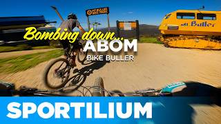
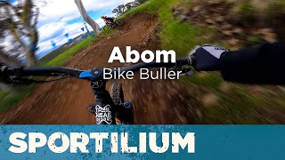
The original downhill trail at Mt Buller, raced and ridden for years, includes fast, open straights with sweeping corners, berms and numerous switchbacks. Begins at Northside Discovery Centre.

Trail Supporters
  • World Trail
    Builder

Bike Park

Traditionally Indigenous Territory

Recent Activity on Trail

Past Week
  • 0 rides
  •  
6 Months
  • 31 rides
  • 15 miles avg distance
All
  • 148 rides
  • Last: Dec 30, 2025
c1c2c3c4
January
February
March
April
May
June
July
August
September
October
November
December
update trails status or condition

ABOM Downhill Trail Reports

statusdatedescription
Apr 24, 2026 @ 11:12am (Australia/Melbourne)
Apr 23, 2026
Closed for the season. See you in November!
Apr 12, 2026 @ 4:24pm (Australia/Melbourne)
Apr 11, 2026
Light dusting of snow
Jan 26, 2026 @ 7:23pm (Australia/Melbourne)
Jan 26, 2026
Open for the summer season
Jan 6, 2026 @ 12:06pm (Australia/Melbourne)
Jan 5, 2026
groomed 6th Jan, heavy use over xmas/ new year has bedded the trail in nicely
Dec 20, 2025 @ 1:53pm (Australia/Melbourne)
Dec 19, 2025
It is clear
more »
Status:
on Apr 24, 2026
Variable
Avg: 4.37 (10 votes)
Your vote: 0

view (3,106)
close
3D
Trail Conditions
  • Unknown
  • Snow Groomed
  • Snow Packed
  • Snow Covered
  • Snow Cover Partial
  • Freeze/thaw Cycle
  • Icy
  • Prevalent Mud
  • Wet
  • Variable
  • Ideal
  • Dry
  • Very Dry
Trail Flow (Ridden Direction)
Trailforks scans users ridelogs to determine the most popular direction each trail is ridden. A good flowing trail network will have most trails flowing in a single direction according to their intension.
The colour categories are based on what percentage of riders are riding a trail in its intended direction.
  • > 96%
  • > 90%
  • > 80%
  • > 70%
  • > 50%
  • < 50%
  • bi-directional trail
  • no data
Trail Last Ridden
Trailforks scans ridelogs to determine the last time a trail was ridden.
  • < 2 days
  • < 1 week
  • < 2 weeks
  • < 1 month
  • < 6 months
  • > 6 months
Trail Ridden Direction
The intended direction a trail should be ridden.
  • Downhill Only
  • Downhill Primary
  • Both Directions
  • Uphill Primary
  • Uphill Only
  • One Direction
Contribute Details
Colors indicate trail is missing specified detail.
  • Description
  • Photos
  • Description & Photos
  • Videos
Trail Popularity ?
Trailforks scans ridelogs to determine which trails are ridden the most in the last 9 months. Trails are compared with nearby trails in the same city region with a possible 25 colour shades. Think of this as a heatmap, more rides = more kinetic energy = warmer colors.
  • most popular
  • popular
  • less popular
  • not popular
ATV/ORV/OHV Filter
Max Vehicle Width
inches
US Cell Coverage
Legend
cell carrier legend

Radar Time
Activity Recordings
Trailforks uses anonymized public activity data. ?
Activity Recordings
Trailforks uses anonymized public activity data. ?
Personal Heatmap
Activity Types
all / none
Options
2
Date range month
Winter Trails
Warning A routing network for winter maps does not exist. Selecting trails using the winter trails layer has been disabled.
Missing Trails
Most Popular
Least Popular
Trails are colored based on popularity. The more popular a trail is, the more red. Less popular trails trend towards green.
Jump Magnitude Heatmap
Heatmap of where riders jump on trails. Zoom in to see individual jumps, click circles to view jump details.
BC Backroad Status

Service Road Atlas is a free to use, community-driven service for viewing and creating reports on the numerous back-country service roads around B.C. and Alberta.

map legend
Slope Aspect
Direction the slope faces
Flat N NE E SE S SW W NW
Trails Deemphasized
Trails are shown in grey.
disable
Only show trails with no bike usage.
Enable
Suggested Layers
Based on selected activity type

    Save the current map location and zoom level as your default home location whenever this page is loaded.
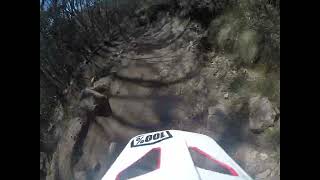
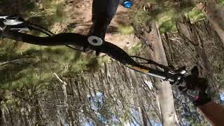
    Save
        Directions to abom-downhill trailhead (-37.142650, 146.440520)

        Photos

        115 more »
        489 |
        Mar 20, 2017 @ 6:14pm
        Mar 20, 2017
        311 |
        Mar 14, 2017 @ 5:48pm
        Mar 14, 2017
        313 |
        Feb 10, 2015 @ 7:30pm
        Feb 10, 2015
        214 |
        Jan 8, 2010 @ 12:28am
        Jan 8, 2010

        Videos

        25 more »
        youtuber Chasing Dan Down Abom | First Time Clearing...
        5:29 | 172 | Jan 20, 2025 , Mt Buller
        youtuber Abom – Bike Buller
        5:37 | 552 | Jan 8, 2022 , Mt Buller
        youtuber Abom - 2025 (Hero 3+)
        4:24 | 27 | Mar 22, 2025 , Mt Buller
        youtuber Abom - 04/01/2025 — ERROR - FLIP 180 DEGREES
        5:35 | 56 | Jan 26, 2026 , Mt Buller

        Routes with this trail

        19 miles 4,195 ft 18 Race
        Course map for final round of the Shimano Enduro Tour. Junior and Challenge riders will not complete Stage...

        Trail Products

        3 Reviews & Comments


        We hope you've been enjoying Trailforks!

        Create a FREE account to view trail comments and much more.

        • By Cameron-1 & contributors
        • #23996 - 5,758 views

        Frequently Asked Questions About ABOM Downhill

        Where is ABOM Downhill located?
        ABOM Downhill is located in Mt Buller Alpine Resort, Mt Buller, Australia. It is part of the Mt Buller Alpine Resort trail network. The trailhead is located at coordinates -37.14265, 146.44052.
        How hard is ABOM Downhill?
        ABOM Downhill is rated as Blue difficulty. The physical rating is Moderate. The average grade is 12.1%.
        What is the elevation gain for ABOM Downhill?
        The trail has 789 ft of elevation descent. The elevation ranges from 4,647 ft to 5,436 ft.
        Is ABOM Downhill a point to point trail?
        Yes, ABOM Downhill is a point to point trail. The direction is Downhill Only. The trail type is singletrack.

        Hit the Trail

        Open in App

        Get this trail on your phone instantly.
        open trail in app

        Download Trail

        Save to wishlist, Garmin & download.
        save the trail

        Find Related Routes

        Find routes and users activities that include this trail.
        find routes for this trail

        You must enter a description before submitting.