more stats
1,355 ft
Distance
-326 ft
Descent
00:10:03
Avg time
-326 ft
Altitude change
2,322 ft
Altitude min
2,648 ft
Altitude max
2,648 ft
Altitude start
2,323 ft
Altitude end
-24%
Grade
-54.8%
Grade max
-4.5%
Grade min
1,335 ft
Distance down
23 ft
Distance flat
00:10:03
Avg time

AC/DC Details

  • Activities
    • Mountain Bike
    • E-Bike
    • Hike
    • Trail Running
  • Riding Area
    Westside - Sproatt
    Whistler, British Columbia
  • Difficulty Rating
  • Voted Difficulty
    Double Black Diamond (1 vote)
  • Local Popularity
    65 in Mountain Biking [+]
    • 65 in E-Biking
    • 35 in Trail Running
    • 30 in Hiking
  • Global Ranking
    #34954 in Mountain Biking [+]
    • #47724 in E-Biking
    • #116174 in Trail Running
    • #119063 in Hiking
  • Hiking SAC Scale
    T2 Mountain Hiking
  • Trail Type
    Singletrack
  • Bike Type
    DH, AM, XC
  • Direction
    Downhill Only
    Popular Direction Shown
  • Physical Rating
    Hard
  • Trail Visibility
    Always easy to follow
  • Dogs Allowed
    Yes
  • eBike Allowed
    Yes up to Class 1
  • TTFs on Trail
    Rock Face

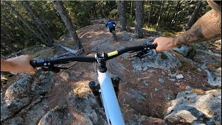
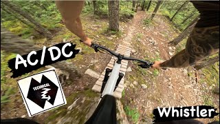
AC-DC is a short trail that tackles some steep rock sections. It is not really a destination in itself but is often linked with High Society and Yoda's

Access Info

The trail starts off Lower Sproatt but it generally ridden following a descent of High Society. At the end of High Society turn right (south) and look for a trail on rider's left after about 20 metres

Local Trail Association

Recent Activity on Trail

Past Week
  • 3 rides
  • 6 miles average
6 Months
  • 24 rides
  • 8 miles avg distance
All
  • 489 rides
  • Last: Jun 19, 2026
c1c2c3c4
January
February
March
April
May
June
July
August
September
October
November
December
Status:
on May 21, 2026
Ideal
Avg: 4.51 (29 votes)
Your vote: 0

view (3,024)
close
3D
Trail Conditions
  • Unknown
  • Snow Groomed
  • Snow Packed
  • Snow Covered
  • Snow Cover Partial
  • Freeze/thaw Cycle
  • Icy
  • Prevalent Mud
  • Wet
  • Variable
  • Ideal
  • Dry
  • Very Dry
Trail Flow (Ridden Direction)
Trailforks scans users ridelogs to determine the most popular direction each trail is ridden. A good flowing trail network will have most trails flowing in a single direction according to their intension.
The colour categories are based on what percentage of riders are riding a trail in its intended direction.
  • > 96%
  • > 90%
  • > 80%
  • > 70%
  • > 50%
  • < 50%
  • bi-directional trail
  • no data
Trail Last Ridden
Trailforks scans ridelogs to determine the last time a trail was ridden.
  • < 2 days
  • < 1 week
  • < 2 weeks
  • < 1 month
  • < 6 months
  • > 6 months
Trail Ridden Direction
The intended direction a trail should be ridden.
  • Downhill Only
  • Downhill Primary
  • Both Directions
  • Uphill Primary
  • Uphill Only
  • One Direction
Contribute Details
Colors indicate trail is missing specified detail.
  • Description
  • Photos
  • Description & Photos
  • Videos
Trail Popularity ?
Trailforks scans ridelogs to determine which trails are ridden the most in the last 9 months. Trails are compared with nearby trails in the same city region with a possible 25 colour shades. Think of this as a heatmap, more rides = more kinetic energy = warmer colors.
  • most popular
  • popular
  • less popular
  • not popular
ATV/ORV/OHV Filter
Max Vehicle Width
inches
US Cell Coverage
Legend
cell carrier legend

Radar Time
Activity Recordings
Trailforks uses anonymized public activity data. ?
Activity Recordings
Trailforks uses anonymized public activity data. ?
Personal Heatmap
Activity Types
all / none
Options
2
Date range month
Winter Trails
Warning A routing network for winter maps does not exist. Selecting trails using the winter trails layer has been disabled.
Missing Trails
Most Popular
Least Popular
Trails are colored based on popularity. The more popular a trail is, the more red. Less popular trails trend towards green.
Jump Magnitude Heatmap
Heatmap of where riders jump on trails. Zoom in to see individual jumps, click circles to view jump details.
BC Backroad Status

Service Road Atlas is a free to use, community-driven service for viewing and creating reports on the numerous back-country service roads around B.C. and Alberta.

map legend
Slope Aspect
Direction the slope faces
Flat N NE E SE S SW W NW
Trails Deemphasized
Trails are shown in grey.
disable
Only show trails with no bike usage.
Enable
Suggested Layers
Based on selected activity type

    Save the current map location and zoom level as your default home location whenever this page is loaded.

    Save
        Directions to ac-dc-1667 trailhead (50.099130, -123.006240)

        Photos

        29 more »
        904 |
        Jul 30, 2017 @ 8:42am
        Jul 30, 2017
        1,922 |
        Sep 15, 2015 @ 7:07pm
        Sep 15, 2015
        105 |
        Sep 13, 2023 @ 8:28pm
        Sep 13, 2023
        94 |
        Sep 13, 2023 @ 8:19pm
        Sep 13, 2023

        Videos

        10 more »
        youtuber ACDC | Double black trail | Whistler
        2:00 | 202 | Nov 27, 2023 , Whistler
        youtuber AC/DC | Double Black Trail | Whistler 2024
        2:21 | 286 | Jun 28, 2024 , Whistler
        youtuber AC DC, Whistler West Side Trails,
        3:56 | 1617 | Jun 15, 2017 , Whistler
        youtuber The 3 Best Gnarly Whistler Westside Slab...
        8:53 | 99 | Jul 28, 2025 , Whistler

        Trail Lists

        Routes with this trail

        2 miles 454 ft 5
        Pinkbike 2024 Fall Field Test - Trail Bike Test Loop
        30 miles 4,490 ft 25
        proposed running race course for Tenderfoot Boogie 2024
        3.0 1 mile 19 ft 5
        WORCA Virtual Thriller Monday, August 12- Saturday, August 17 Collect your badge to earn your Apres deal...

        Trail Products

        6 Reviews & Comments


        We hope you've been enjoying Trailforks!

        Create a FREE account to view trail comments and much more.

        • By canadakaTF Pro Trailforks & contributors
        • #1667 - 11,201 views

        Frequently Asked Questions About AC/DC

        Where is AC/DC located?
        AC/DC is located in Westside - Sproatt, Whistler, British Columbia, Canada. It is part of the Westside - Sproatt trail network. The trailhead is located at coordinates 50.09913, -123.00624.
        How hard is AC/DC?
        AC/DC is rated as Double Black Diamond difficulty. The physical rating is Hard. The average grade is 24%.
        What is the elevation gain for AC/DC?
        The trail has 326 ft of elevation descent. The elevation ranges from 2,322 ft to 2,648 ft.
        Is AC/DC a point to point trail?
        Yes, AC/DC is a point to point trail. The direction is Downhill Only. The trail type is singletrack.

        Hit the Trail

        Open in App

        Get this trail on your phone instantly.
        open trail in app

        Download Trail

        Save to wishlist, Garmin & download.
        save the trail

        Find Related Routes

        Find routes and users activities that include this trail.
        find routes for this trail

        You must enter a description before submitting.