more stats
1.2 miles
Distance
8 ft
Climb
-423 ft
Descent
00:06:23
Avg time
-415 ft
Altitude change
644 ft
Altitude min
1,069 ft
Altitude max
1,059 ft
Altitude start
643 ft
Altitude end
-6.7%
Grade
-32.4%
Grade max
12.8%
Grade min
203 ft
Distance climb
1 mile
Distance down
640 ft
Distance flat
00:06:23
Avg time

Acer Spades Details

  • Activities
    • Mountain Bike
    • E-Bike
    • Winter Fat Bike
  • Riding Area
    Thurston Hills Natural Area
    Springfield, Oregon
  • Difficulty Rating
  • Local Popularity
    100 in Mountain Biking [+]
    • 100 in E-Biking
  • Global Ranking
    #29334 in Mountain Biking
  • Trail Type
    Singletrack
  • Bike Type
    DH, AM, XC, Fat
  • Direction
    Downhill Only
    Popular Direction Shown
  • Climb Difficulty
    Green
  • Physical Rating
    Easy
  • Dogs Allowed
    Yes
  • eBike Allowed
    Yes up to Class 1
  • TTFs on Trail
    Berm
  • Year Opened
    2018
  • Land Owner

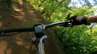
A fast, flowing downhill trail with no technical features other than some swooping berms interspersed with some bumps. The upper portion may be beyond the liking of absolute beginners. There is a tie-in to the lower portion which may be more appropriate for these riders.

Access Info

There is a tie-in connection from Lower Mossy Maple to the lower portion of this trail for sessioning some easier flow rides (making a 3/4 mile circuit). There is also a connection across Lower Mossy Maple trail from the end of Yew Haw and shortly before the extension to Lower Mossy Maple branches off to the left.

Local Trail Association

Recent Activity on Trail

Past Week
  • 5 rides
  • 7.6 km average
6 Months
  • 45 rides
  • 12.0 km avg distance
All
  • 613 rides
  • Last: Jun 17, 2026
c1c2c3c4
January
February
March
April
May
June
July
August
September
October
November
December
Status:
on May 15, 2026
Ideal
Avg: 4.27 (12 votes)
Your vote: 0

view (4,074)
close
3D
Trail Conditions
  • Unknown
  • Snow Groomed
  • Snow Packed
  • Snow Covered
  • Snow Cover Partial
  • Freeze/thaw Cycle
  • Icy
  • Prevalent Mud
  • Wet
  • Variable
  • Ideal
  • Dry
  • Very Dry
Trail Flow (Ridden Direction)
Trailforks scans users ridelogs to determine the most popular direction each trail is ridden. A good flowing trail network will have most trails flowing in a single direction according to their intension.
The colour categories are based on what percentage of riders are riding a trail in its intended direction.
  • > 96%
  • > 90%
  • > 80%
  • > 70%
  • > 50%
  • < 50%
  • bi-directional trail
  • no data
Trail Last Ridden
Trailforks scans ridelogs to determine the last time a trail was ridden.
  • < 2 days
  • < 1 week
  • < 2 weeks
  • < 1 month
  • < 6 months
  • > 6 months
Trail Ridden Direction
The intended direction a trail should be ridden.
  • Downhill Only
  • Downhill Primary
  • Both Directions
  • Uphill Primary
  • Uphill Only
  • One Direction
Contribute Details
Colors indicate trail is missing specified detail.
  • Description
  • Photos
  • Description & Photos
  • Videos
Trail Popularity ?
Trailforks scans ridelogs to determine which trails are ridden the most in the last 9 months. Trails are compared with nearby trails in the same city region with a possible 25 colour shades. Think of this as a heatmap, more rides = more kinetic energy = warmer colors.
  • most popular
  • popular
  • less popular
  • not popular
ATV/ORV/OHV Filter
Max Vehicle Width
inches
US Cell Coverage
Legend
cell carrier legend

Radar Time
Activity Recordings
Trailforks uses anonymized public activity data. ?
Activity Recordings
Trailforks uses anonymized public activity data. ?
Personal Heatmap
Activity Types
all / none
Options
2
Date range month
Winter Trails
Warning A routing network for winter maps does not exist. Selecting trails using the winter trails layer has been disabled.
Missing Trails
Most Popular
Least Popular
Trails are colored based on popularity. The more popular a trail is, the more red. Less popular trails trend towards green.
Jump Magnitude Heatmap
Heatmap of where riders jump on trails. Zoom in to see individual jumps, click circles to view jump details.
BC Backroad Status

Service Road Atlas is a free to use, community-driven service for viewing and creating reports on the numerous back-country service roads around B.C. and Alberta.

map legend
Slope Aspect
Direction the slope faces
Flat N NE E SE S SW W NW
Trails Deemphasized
Trails are shown in grey.
disable
Only show trails with no bike usage.
Enable
Suggested Layers
Based on selected activity type

    Save the current map location and zoom level as your default home location whenever this page is loaded.

    Save
        Directions to acer-spades trailhead (44.038460, -122.888100)

        Photos

        13 more »
        37 |
        Dec 4, 2024 @ 1:40pm
        Dec 4, 2024
        120 |
        Jul 1, 2022 @ 8:28pm
        Jul 1, 2022
        188 |
        Apr 4, 2021 @ 11:08pm
        Apr 4, 2021
        230 |
        Aug 15, 2019 @ 10:34pm
        Aug 15, 2019

        Videos

        2 more »
        Thurston Hill Natural Area: Acer Spades
        5:20 | 59 | Jul 29, 2025 , Springfield
        Mountain biking Acer Spades trail at Thurston...
        5:37 | 798 | Oct 4, 2021 , Springfield

        16 Reviews & Comments


        We hope you've been enjoying Trailforks!

        Create a FREE account to view trail comments and much more.

        • By TillikumTF Pro & contributors
        • #135218 - 4,628 views

        Frequently Asked Questions About Acer Spades

        Where is Acer Spades located?
        Acer Spades is located in Thurston Hills Natural Area, Springfield, Oregon, United States. It is part of the Thurston Hills Natural Area trail network. The trailhead is located at coordinates 44.03846, -122.8881.
        How hard is Acer Spades?
        Acer Spades is rated as Green difficulty. The physical rating is Easy. The average grade is 6.7%. The climb difficulty is rated Green.
        What is the elevation gain for Acer Spades?
        Acer Spades has 8 ft of elevation gain. The trail has 423 ft of elevation descent. The elevation ranges from 644 ft to 1,069 ft.
        Is Acer Spades a point to point trail?
        Yes, Acer Spades is a point to point trail. The direction is Downhill Only. The trail type is singletrack.

        Hit the Trail

        Open in App

        Get this trail on your phone instantly.
        open trail in app

        Download Trail

        Save to wishlist, Garmin & download.
        save the trail

        Find Related Routes

        Find routes and users activities that include this trail.
        find routes for this trail

        You must enter a description before submitting.