more stats
1,240 ft
Distance
-83 ft
Descent
00:44:13
Avg time
-83 ft
Altitude change
407 ft
Altitude min
490 ft
Altitude max
490 ft
Altitude start
407 ft
Altitude end
-11.171%
Grade max
-0.254%
Grade min
1,198 ft
Distance down
41 ft
Distance flat
00:44:13
Avg time

Adel Jumps Details

  • Activities
    • Mountain Bike
    • Hike
    • Trail Running
  • Riding Area
  • Difficulty Rating
  • Local Popularity
    65 in Mountain Biking [+]
    • 5 in Trail Running
    • 5 in Hiking
  • Global Ranking
    #170319 in Mountain Biking [+]
    • #129304 in Trail Running
    • #122305 in Hiking
  • Trail Type
    Singletrack
  • Bike Type
    DH, AM, DJ
  • Direction
    Downhill Primary
  • Climb Difficulty
    Green
  • Physical Rating
    Moderate
  • Season
    All year round
  • Dogs Allowed
    Yes
  • eBike Allowed
    Yes up to Class 1
  • TTFs on Trail
    Drop, Jump
  • Year Opened
    2007

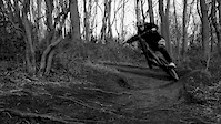
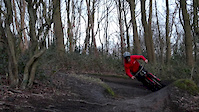
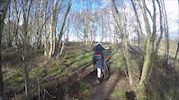
Trails with jumps ranging from beginner to advanced, made up of several different lines. Can become quite muddy after several days of wet weather, however ride very well when dry. The trails aren't particularly steep so it is easy to keep your speed under control. The trails do cross over paths so always give pedestrians right of way, recently cases of vandalism have happened to some of the take offs and landings of jumps so always check the trail before you ride it.

Access Info

Accessed via Stairfoot Lane, Adel, Leeds. Parking is available in the Adel woods car park and the trails are across the road from the car park.

Local Trail Association

Recent Activity on Trail

Past Week
  • 0 rides
  •  
6 Months
  • 2 rides
  • 6 miles avg distance
All
  • 17 rides
  • Last: Jun 6, 2026
c1c2c3c4
January
February
March
April
May
June
July
August
September
October
November
December
update trails status or condition

Adel Jumps Trail Reports

Status:
on Jun 29, 2025
Dry
no votes yet
Your vote: 0

view (1,100)
close
3D
Trail Conditions
  • Unknown
  • Snow Groomed
  • Snow Packed
  • Snow Covered
  • Snow Cover Partial
  • Freeze/thaw Cycle
  • Icy
  • Prevalent Mud
  • Wet
  • Variable
  • Ideal
  • Dry
  • Very Dry
Trail Flow (Ridden Direction)
Trailforks scans users ridelogs to determine the most popular direction each trail is ridden. A good flowing trail network will have most trails flowing in a single direction according to their intension.
The colour categories are based on what percentage of riders are riding a trail in its intended direction.
  • > 96%
  • > 90%
  • > 80%
  • > 70%
  • > 50%
  • < 50%
  • bi-directional trail
  • no data
Trail Last Ridden
Trailforks scans ridelogs to determine the last time a trail was ridden.
  • < 2 days
  • < 1 week
  • < 2 weeks
  • < 1 month
  • < 6 months
  • > 6 months
Trail Ridden Direction
The intended direction a trail should be ridden.
  • Downhill Only
  • Downhill Primary
  • Both Directions
  • Uphill Primary
  • Uphill Only
  • One Direction
Contribute Details
Colors indicate trail is missing specified detail.
  • Description
  • Photos
  • Description & Photos
  • Videos
Trail Popularity ?
Trailforks scans ridelogs to determine which trails are ridden the most in the last 9 months. Trails are compared with nearby trails in the same city region with a possible 25 colour shades. Think of this as a heatmap, more rides = more kinetic energy = warmer colors.
  • most popular
  • popular
  • less popular
  • not popular
ATV/ORV/OHV Filter
Max Vehicle Width
inches
US Cell Coverage
Legend
cell carrier legend

Radar Time
Activity Recordings
Trailforks uses anonymized public activity data. ?
Activity Recordings
Trailforks uses anonymized public activity data. ?
Personal Heatmap
Activity Types
all / none
Options
2
Date range month
Winter Trails
Warning A routing network for winter maps does not exist. Selecting trails using the winter trails layer has been disabled.
Missing Trails
Most Popular
Least Popular
Trails are colored based on popularity. The more popular a trail is, the more red. Less popular trails trend towards green.
Jump Magnitude Heatmap
Heatmap of where riders jump on trails. Zoom in to see individual jumps, click circles to view jump details.
BC Backroad Status

Service Road Atlas is a free to use, community-driven service for viewing and creating reports on the numerous back-country service roads around B.C. and Alberta.

map legend
Slope Aspect
Direction the slope faces
Flat N NE E SE S SW W NW
Trails Deemphasized
Trails are shown in grey.
disable
Only show trails with no bike usage.
Enable
Suggested Layers
Based on selected activity type

    Save the current map location and zoom level as your default home location whenever this page is loaded.

    Save
        Directions to adel-jumps trailhead (53.859150, -1.573310)

        Photos

        56 more »
        474 |
        Apr 28, 2017 @ 12:41pm
        Apr 28, 2017
        396 |
        Feb 22, 2015 @ 2:18am
        Feb 22, 2015
        227 |
        Apr 28, 2017 @ 12:41pm
        Apr 28, 2017
        34 |
        Nov 27, 2024 @ 12:19pm
        Nov 27, 2024

        Videos

        8 more »
        Adel - 'The Theatre of Dreams LS16'
        3:00 | 1527 | May 4, 2020 , Leeds
        FOR A LIMITED TIME ONLY
        2:48 | 356 | Mar 25, 2019 , Leeds
        'Dream' Build - Santa Cruz Bronson
        2:01 | 248 | Mar 24, 2019 , Leeds
        Edit from new jump line at adel.
        0:24 | 217 | Apr 7, 2016 , Leeds

        2 Reviews & Comments


        We hope you've been enjoying Trailforks!

        Create a FREE account to view trail comments and much more.

        • By willbikeleeds & contributors
        • #28825 - 10,656 views

        Frequently Asked Questions About Adel Jumps

        Where is Adel Jumps located?
        Adel Jumps is located in Leeds, United Kingdom. It is part of the Leeds trail network. The trailhead is located at coordinates 53.85915, -1.57331.
        How hard is Adel Jumps?
        Adel Jumps is rated as Blue difficulty. The physical rating is Moderate. The climb difficulty is rated Green.
        What is the elevation gain for Adel Jumps?
        The trail has 25 m of elevation descent. The elevation ranges from 124 m to 149 m.
        Is Adel Jumps a point to point trail?
        Adel Jumps is not a point to point trail. The direction is Downhill Primary. The trail type is singletrack.

        Hit the Trail

        Open in App

        Get this trail on your phone instantly.
        open trail in app

        Download Trail

        Save to wishlist, Garmin & download.
        save the trail

        Find Related Routes

        Find routes and users activities that include this trail.
        find routes for this trail

        You must enter a description before submitting.