more stats
4,593 ft
Distance
3 ft
Climb
-653 ft
Descent
00:10:41
Avg time
-649 ft
Altitude change
449 ft
Altitude min
1,098 ft
Altitude max
1,098 ft
Altitude start
449 ft
Altitude end
-14.1%
Grade
-47.5%
Grade max
6.3%
Grade min
30 ft
Distance climb
4,462 ft
Distance down
102 ft
Distance flat
00:10:41
Avg time

Ae Downhill Details

  • Activities
    • Mountain Bike
    • E-Bike
  • Riding Area
  • Difficulty Rating
  • Voted Difficulty
    Black (1 vote)
  • Local Popularity
    70 in Mountain Biking [+]
    • 75 in E-Biking
  • Global Ranking
    #70341 in Mountain Biking [+]
    • #44080 in E-Biking
  • Trail Type
    Singletrack
  • Bike Type
    DH
  • Direction
    One Direction
    Popular Direction Shown
  • Physical Rating
    Hard
  • Trail Visibility
    Always easy to follow
  • Season
    all year just be more cautious in the wet obviously
  • eBike Allowed
    Yes up to Class 1
  • TTFs on Trail
    Berm, Drop, Jump, Gap Jump, Rock Garden

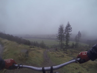
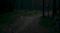
Awesome trail. Good mix of techy roots, jumps, step down, gaps, berms and rocky sections. There is lots of different options to go. There is three main lines off the top. Then after these you get into the first root section over a small burn gap (optional) then into some built up berms and tabletops, down some stairs and a nice wee drop takes you onto the halfway forest road. Off the fire road into the next half there is an option to do a gap jump or the rock garden. After this keep left for a fast section of trail which is okay but it contains the coffin jump (only for the brave) . Or you can take the line to the right for a more natural roots section. Now you are into the final section. There is the option to do some more tech lines or some big jumps the step down are the other options. The trail finishes with a fast section where you need to pedal.The other option is the elevator which is a massive steep chute which drops you onto the field The trail is very manageable on a all mountain bike as all the big features have a chicken line round them.

Recent Activity on Trail

Past Week
  • 0 rides
  •  
6 Months
  • 0 rides
  •  
All
  • 15 rides
  • Last: Jun 8, 2026
c1c2c3c4
January
February
March
April
May
June
July
August
September
October
November
December
update trails status or condition

Ae Downhill Trail Reports

statusdatedescription
Mar 5, 2025 @ 1:40am
Mar 5, 2025
The main line is clear. A tree is down on the event-sanctioned option line in the lower half of the DH track, which is closed off with orange...
Feb 15, 2025 @ 11:28am
Feb 15, 2025
Shredder is closed until further notice. There are multiple trees over the trail in the upper section, and both access routes are blocked by...
May 15, 2022 @ 11:08am
May 15, 2022
All clear
Jan 29, 2022 @ 3:15am
Jan 29, 2022
reporter The access road to the trig point and main 7stanes trails - SHREDDER & Downhill are now open. Trail update 29/01/22 AE forest - Red - OPEN...
Nov 27, 2021 @ 1:04pm
Nov 27, 2021
reporter All mountain bike trails in Dalbeattie, Mabie, and Ae forest are currently closed until further notice due to multiple wind-blown trees across and...
more »
Status:
on Mar 5, 2025
Variable
Avg: 4.17 (5 votes)
Your vote: 0

view (516)
close
3D
Trail Conditions
  • Unknown
  • Snow Groomed
  • Snow Packed
  • Snow Covered
  • Snow Cover Partial
  • Freeze/thaw Cycle
  • Icy
  • Prevalent Mud
  • Wet
  • Variable
  • Ideal
  • Dry
  • Very Dry
Trail Flow (Ridden Direction)
Trailforks scans users ridelogs to determine the most popular direction each trail is ridden. A good flowing trail network will have most trails flowing in a single direction according to their intension.
The colour categories are based on what percentage of riders are riding a trail in its intended direction.
  • > 96%
  • > 90%
  • > 80%
  • > 70%
  • > 50%
  • < 50%
  • bi-directional trail
  • no data
Trail Last Ridden
Trailforks scans ridelogs to determine the last time a trail was ridden.
  • < 2 days
  • < 1 week
  • < 2 weeks
  • < 1 month
  • < 6 months
  • > 6 months
Trail Ridden Direction
The intended direction a trail should be ridden.
  • Downhill Only
  • Downhill Primary
  • Both Directions
  • Uphill Primary
  • Uphill Only
  • One Direction
Contribute Details
Colors indicate trail is missing specified detail.
  • Description
  • Photos
  • Description & Photos
  • Videos
Trail Popularity ?
Trailforks scans ridelogs to determine which trails are ridden the most in the last 9 months. Trails are compared with nearby trails in the same city region with a possible 25 colour shades. Think of this as a heatmap, more rides = more kinetic energy = warmer colors.
  • most popular
  • popular
  • less popular
  • not popular
ATV/ORV/OHV Filter
Max Vehicle Width
inches
US Cell Coverage
Legend
cell carrier legend

Radar Time
Activity Recordings
Trailforks uses anonymized public activity data. ?
Activity Recordings
Trailforks uses anonymized public activity data. ?
Personal Heatmap
Activity Types
all / none
Options
2
Date range month
Winter Trails
Warning A routing network for winter maps does not exist. Selecting trails using the winter trails layer has been disabled.
Missing Trails
Most Popular
Least Popular
Trails are colored based on popularity. The more popular a trail is, the more red. Less popular trails trend towards green.
Jump Magnitude Heatmap
Heatmap of where riders jump on trails. Zoom in to see individual jumps, click circles to view jump details.
BC Backroad Status

Service Road Atlas is a free to use, community-driven service for viewing and creating reports on the numerous back-country service roads around B.C. and Alberta.

map legend
Slope Aspect
Direction the slope faces
Flat N NE E SE S SW W NW
Trails Deemphasized
Trails are shown in grey.
disable
Only show trails with no bike usage.
Enable
Suggested Layers
Based on selected activity type

    Save the current map location and zoom level as your default home location whenever this page is loaded.

    Save
        Directions to ae-downhill trailhead (55.199270, -3.589610)

        Photos

        743 more »
        198 |
        May 7, 2009 @ 5:37am
        May 7, 2009
        193 |
        May 7, 2009 @ 5:37am
        May 7, 2009
        159 |
        May 7, 2009 @ 5:38am
        May 7, 2009
        295 |
        May 7, 2009 @ 5:42am
        May 7, 2009

        Videos

        43 more »
        Hitting Ae Step Down
        0:06 | 875 | Jan 30, 2018 , My City
        Ae Forest 28/08/22
        8:13 | 156 | Aug 30, 2022 , My City
        sda drop
        0:23 | 227 | Jan 13, 2021 , My City
        IN TO THE MIST
        0:58 | 173 | Jan 7, 2020 , My City

        Reviews / Comments

        No reviews yet, be the first to write a review or ask a question.
        Use trail reports to comment on trail conditions.


        We hope you've been enjoying Trailforks!

        Create a FREE account to view trail comments and much more.

        Frequently Asked Questions About Ae Downhill

        Where is Ae Downhill located?
        Ae Downhill is located in Forest of Ae. It is part of the Forest of Ae trail network. The trailhead is located at coordinates 55.19927, -3.58961.
        How hard is Ae Downhill?
        Ae Downhill is rated as Proline difficulty. The physical rating is Hard. The average grade is 14.1%.
        What is the elevation gain for Ae Downhill?
        Ae Downhill has 3 ft of elevation gain. The trail has 653 ft of elevation descent. The elevation ranges from 449 ft to 1,098 ft.
        Is Ae Downhill a point to point trail?
        Yes, Ae Downhill is a point to point trail. The direction is One Direction. The trail type is singletrack.

        Hit the Trail

        Open in App

        Get this trail on your phone instantly.
        open trail in app

        Download Trail

        Save to wishlist, Garmin & download.
        save the trail

        Find Related Routes

        Find routes and users activities that include this trail.
        find routes for this trail

        You must enter a description before submitting.