This trail is permanently closed/decommissioned
more stats
1,402 ft
Distance
112 ft
Climb
-42 ft
Descent
00:05:21
Avg time
70 ft
Altitude change
1,974 ft
Altitude min
2,085 ft
Altitude max
2,015 ft
Altitude start
2,085 ft
Altitude end
5.012%
Grade
-24.647%
Grade max
37.382%
Grade min
901 ft
Distance climb
391 ft
Distance down
110 ft
Distance flat
00:05:21
Avg time

Air Supply Details

  • Activities
    • Mountain Bike
    • E-Bike
  • Riding Area
    Mount Fromme
    North Vancouver, British Columbia
  • Difficulty Rating
  • Voted Difficulty
    Double Black Diamond (8 votes)
  • Local Popularity
    50 in Mountain Biking [+]
    • 55 in E-Biking
  • Trail Type
    Singletrack
  • Bike Type
    DH
  • Direction
    Downhill Primary
    Popular Direction Shown
  • Physical Rating
    Moderate
  • Dogs Allowed
    Yes
  • eBike Allowed
  • TTFs on Trail
    Drop, Jump, Roller Coaster, Skinny

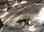
Could be considered one of the most dangerous trails on the north shore. The most recognizable feature is the famous road gap. Air supply also has a series of gap jumps, a swivel teeter totter, some narrow and high ladders, and some rock. If you feel like you want to ride this trail do it on a very dry day with as many safety precautions as necessary.

Recent Activity on Trail

Past Week
  • 1 rides
  • 7 miles average
6 Months
  • 16 rides
  • 10 miles avg distance
All
  • 167 rides
  • Last: Jun 16, 2026
c1c2c3c4
January
February
March
April
May
June
July
August
September
October
November
December
update trails status or condition

Air Supply Trail Reports

statusdatedescription
May 30, 2025 @ 3:05pm
May 30, 2025
Most of the features are in unridable shape. I used the trail in reverse as a connection trail between dyier and oilcan, it's usable that way.
Jun 28, 2023 @ 12:05pm
Jun 28, 2023
Jun 7, 2023 @ 9:54am
Jun 7, 2023
Jun 10, 2021 @ 1:11pm
Jun 10, 2021
Most of the features are gone. Basically an access trail.
Mar 25, 2021 @ 10:51am
Mar 25, 2021
Some snow, mostly ridable to get across to Lower Oilcan
more »
Status:
on May 30, 2025
Wet
Avg: 4.11 (12 votes)
Your vote: 0

view (976)
close
3D
Trail Conditions
  • Unknown
  • Snow Groomed
  • Snow Packed
  • Snow Covered
  • Snow Cover Partial
  • Freeze/thaw Cycle
  • Icy
  • Prevalent Mud
  • Wet
  • Variable
  • Ideal
  • Dry
  • Very Dry
Trail Flow (Ridden Direction)
Trailforks scans users ridelogs to determine the most popular direction each trail is ridden. A good flowing trail network will have most trails flowing in a single direction according to their intension.
The colour categories are based on what percentage of riders are riding a trail in its intended direction.
  • > 96%
  • > 90%
  • > 80%
  • > 70%
  • > 50%
  • < 50%
  • bi-directional trail
  • no data
Trail Last Ridden
Trailforks scans ridelogs to determine the last time a trail was ridden.
  • < 2 days
  • < 1 week
  • < 2 weeks
  • < 1 month
  • < 6 months
  • > 6 months
Trail Ridden Direction
The intended direction a trail should be ridden.
  • Downhill Only
  • Downhill Primary
  • Both Directions
  • Uphill Primary
  • Uphill Only
  • One Direction
Contribute Details
Colors indicate trail is missing specified detail.
  • Description
  • Photos
  • Description & Photos
  • Videos
Trail Popularity ?
Trailforks scans ridelogs to determine which trails are ridden the most in the last 9 months. Trails are compared with nearby trails in the same city region with a possible 25 colour shades. Think of this as a heatmap, more rides = more kinetic energy = warmer colors.
  • most popular
  • popular
  • less popular
  • not popular
ATV/ORV/OHV Filter
Max Vehicle Width
inches
US Cell Coverage
Legend
cell carrier legend

Radar Time
Activity Recordings
Trailforks uses anonymized public activity data. ?
Activity Recordings
Trailforks uses anonymized public activity data. ?
Personal Heatmap
Activity Types
all / none
Options
2
Date range month
Winter Trails
Warning A routing network for winter maps does not exist. Selecting trails using the winter trails layer has been disabled.
Missing Trails
Most Popular
Least Popular
Trails are colored based on popularity. The more popular a trail is, the more red. Less popular trails trend towards green.
Jump Magnitude Heatmap
Heatmap of where riders jump on trails. Zoom in to see individual jumps, click circles to view jump details.
BC Backroad Status

Service Road Atlas is a free to use, community-driven service for viewing and creating reports on the numerous back-country service roads around B.C. and Alberta.

map legend
Slope Aspect
Direction the slope faces
Flat N NE E SE S SW W NW
Trails Deemphasized
Trails are shown in grey.
disable
Only show trails with no bike usage.
Enable
Suggested Layers
Based on selected activity type

    Save the current map location and zoom level as your default home location whenever this page is loaded.

    Save
        Directions to air-supply trailhead (49.356810, -123.062290)

        Photos

        253 more »
        3,332 |
        Nov 25, 2006 @ 7:35am
        Nov 25, 2006
        1,716 |
        Jul 29, 2009 @ 4:48pm
        Jul 29, 2009
        593 |
        Feb 29, 2004 @ 7:43pm
        Feb 29, 2004
        378 |
        Feb 29, 2004 @ 7:43pm
        Feb 29, 2004

        Videos

        6 more »
        Bits & Bites 060 Mount Fromme Trail: Air...
        0:46 | 454 | Oct 30, 2023 , North Vancouver
        Air supply Road gap
        0:35 | 5086 | Jul 30, 2009 , North Vancouver
        Corey
        0:11 | 996 | Jan 8, 2008 , North Vancouver
        Aido
        0:06 | 571 | Jan 8, 2008 , North Vancouver

        15 Reviews & Comments


        We hope you've been enjoying Trailforks!

        Create a FREE account to view trail comments and much more.

        • By canadakaTF Pro Trailforks & contributors
        • #19607 - 16,627 views

        Frequently Asked Questions About Air Supply

        Where is Air Supply located?
        Air Supply is located in Mount Fromme, North Vancouver, British Columbia, Canada. It is part of the Mount Fromme trail network. The trailhead is located at coordinates 49.35681, -123.06229.
        How hard is Air Supply?
        Air Supply is rated as Proline difficulty. The physical rating is Moderate. The average grade is 5.012%.
        What is the elevation gain for Air Supply?
        Air Supply has 112 ft of elevation gain. The trail has 42 ft of elevation descent. The elevation ranges from 1,974 ft to 2,085 ft.
        Is Air Supply a point to point trail?
        Air Supply is not a point to point trail. The direction is Downhill Primary. The trail type is singletrack.

        Hit the Trail

        Open in App

        Get this trail on your phone instantly.
        open trail in app

        Download Trail

        Save to wishlist, Garmin & download.
        save the trail

        Find Related Routes

        Find routes and users activities that include this trail.
        find routes for this trail

        You must enter a description before submitting.