more stats
1.2 miles
Distance
139 ft
Climb
-140 ft
Descent
00:12:56
Avg time
0 ft
Altitude change
611 ft
Altitude min
667 ft
Altitude max
635 ft
Altitude start
633 ft
Altitude end
-20%
Grade max
18%
Grade min
2,726 ft
Distance climb
2,346 ft
Distance down
1,129 ft
Distance flat
00:12:56
Avg time

Alpha Details

  • Activities
    • Mountain Bike
    • E-Bike
    • Winter Fat Bike
    • Hike
    • Trail Running
  • Riding Area
    Griffin Bike Park
    Terre Haute, Indiana
  • Difficulty Rating
  • Local Popularity
    70 in Mountain Biking [+]
    • 95 in E-Biking
    • 5 in Trail Running
    • 45 in Hiking
  • Global Ranking
    #83196 in Mountain Biking [+]
    • #28236 in E-Biking
    • #220334 in Trail Running
    • #112587 in Hiking
  • Hiking SAC Scale
    T2 Mountain Hiking
  • Trail Type
    Singletrack
  • Bike Type
    AM, XC, Fat
  • Direction
    Both Directions
  • Climb Difficulty
    Blue
  • Physical Rating
    Moderate
  • Trail Visibility
    Always easy to follow
  • eBike Allowed
    Yes up to Class 1
  • TTFs on Trail
    Berm, Drop, Jump, Rock Garden
  • Year Opened
    2017
  • Land Owner

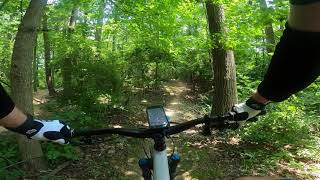
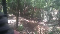
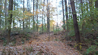
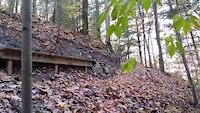
From the Freedom Trail, this trail starts with a short but furious uphill section heading west and a fast, short saddle rising into another short climb. A sustained downhill section follows. The singletrack then enters into a longish climb and passes the entrance to the Proving Grounds Advanced Drop at left. Alpha then becomes a series of descents, rises, and switchbacks among many small ridges, and eventually crosses a long wooden bridge and passes the Landing Zone before heading back north. The return has a fun jump, a challenging uphill section and ends with a wooden berm and wooden bridge features and some last downhill fun—ending at FreedomTrail just south of the Alpha entrance.

Trail Supporters
  • Sponsor

Recent Activity on Trail

Past Week
  • 0 rides
  •  
6 Months
  • 6 rides
  • 21 miles avg distance
All
  • 107 rides
  • Last: Jun 7, 2026
c1c2c3c4
January
February
March
April
May
June
July
August
September
October
November
December
Status:
on Jun 16, 2026
Prevalent Mud
Avg: 4.1 (3 votes)
Your vote: 0

view (1,072)
close
3D
Trail Conditions
  • Unknown
  • Snow Groomed
  • Snow Packed
  • Snow Covered
  • Snow Cover Partial
  • Freeze/thaw Cycle
  • Icy
  • Prevalent Mud
  • Wet
  • Variable
  • Ideal
  • Dry
  • Very Dry
Trail Flow (Ridden Direction)
Trailforks scans users ridelogs to determine the most popular direction each trail is ridden. A good flowing trail network will have most trails flowing in a single direction according to their intension.
The colour categories are based on what percentage of riders are riding a trail in its intended direction.
  • > 96%
  • > 90%
  • > 80%
  • > 70%
  • > 50%
  • < 50%
  • bi-directional trail
  • no data
Trail Last Ridden
Trailforks scans ridelogs to determine the last time a trail was ridden.
  • < 2 days
  • < 1 week
  • < 2 weeks
  • < 1 month
  • < 6 months
  • > 6 months
Trail Ridden Direction
The intended direction a trail should be ridden.
  • Downhill Only
  • Downhill Primary
  • Both Directions
  • Uphill Primary
  • Uphill Only
  • One Direction
Contribute Details
Colors indicate trail is missing specified detail.
  • Description
  • Photos
  • Description & Photos
  • Videos
Trail Popularity ?
Trailforks scans ridelogs to determine which trails are ridden the most in the last 9 months. Trails are compared with nearby trails in the same city region with a possible 25 colour shades. Think of this as a heatmap, more rides = more kinetic energy = warmer colors.
  • most popular
  • popular
  • less popular
  • not popular
ATV/ORV/OHV Filter
Max Vehicle Width
inches
US Cell Coverage
Legend
cell carrier legend

Radar Time
Activity Recordings
Trailforks uses anonymized public activity data. ?
Activity Recordings
Trailforks uses anonymized public activity data. ?
Personal Heatmap
Activity Types
all / none
Options
2
Date range month
Winter Trails
Warning A routing network for winter maps does not exist. Selecting trails using the winter trails layer has been disabled.
Missing Trails
Most Popular
Least Popular
Trails are colored based on popularity. The more popular a trail is, the more red. Less popular trails trend towards green.
Jump Magnitude Heatmap
Heatmap of where riders jump on trails. Zoom in to see individual jumps, click circles to view jump details.
BC Backroad Status

Service Road Atlas is a free to use, community-driven service for viewing and creating reports on the numerous back-country service roads around B.C. and Alberta.

map legend
Slope Aspect
Direction the slope faces
Flat N NE E SE S SW W NW
Trails Deemphasized
Trails are shown in grey.
disable
Only show trails with no bike usage.
Enable
Suggested Layers
Based on selected activity type

    Save the current map location and zoom level as your default home location whenever this page is loaded.

    Save
        Directions to alpha-316711 trailhead (39.339300, -87.362840)

        Photos

        1 more »
        46 |
        Oct 24, 2024 @ 6:05pm
        Oct 24, 2024

        Videos

        4 more »
        Alpha - Specialized Status - Griffin Bike Park...
        8:52 | 276 | Jul 15, 2021 , Terre Haute
        step up alpha
        0:12 | 90 | Jan 18, 2021 , Terre Haute
        flying high
        0:05 | 96 | Jan 18, 2021 , Terre Haute
        alpha
        0:20 | 107 | Jan 18, 2021 , Terre Haute

        Reviews / Comments

        No reviews yet, be the first to write a review or ask a question.
        Use trail reports to comment on trail conditions.


        We hope you've been enjoying Trailforks!

        Create a FREE account to view trail comments and much more.

        • By RichMoore65TF Pro FOGBP & contributors
        • #316711 - 1,390 views

        Frequently Asked Questions About Alpha

        Where is Alpha located?
        Alpha is located in Griffin Bike Park, Terre Haute, Indiana, United States. It is part of the Griffin Bike Park trail network. The trailhead is located at coordinates 39.3393, -87.36284.
        How hard is Alpha?
        Alpha is rated as Blue difficulty. The physical rating is Moderate. The climb difficulty is rated Blue.
        What is the elevation gain for Alpha?
        Alpha has 139 ft of elevation gain. The trail has 140 ft of elevation descent. The elevation ranges from 611 ft to 667 ft.
        Is Alpha a point to point trail?
        Alpha is not a point to point trail. The direction is Both Directions. The trail type is singletrack.

        Hit the Trail

        Open in App

        Get this trail on your phone instantly.
        open trail in app

        Download Trail

        Save to wishlist, Garmin & download.
        save the trail

        Find Related Routes

        Find routes and users activities that include this trail.
        find routes for this trail

        You must enter a description before submitting.