more stats
2.2 miles
Distance
297 ft
Climb
-1,468 ft
Descent
00:19:38
Avg time
-1,171 ft
Altitude change
1,863 ft
Altitude min
3,034 ft
Altitude max
3,034 ft
Altitude start
1,863 ft
Altitude end
-9.995%
Grade
-37.165%
Grade max
28.131%
Grade min
2,709 ft
Distance climb
2 miles
Distance down
146 ft
Distance flat
00:19:38
Avg time

Anakonda Details

  • Activities
    • Mountain Bike
    • Hike
    • Trail Running
  • Riding Area
    Minčol
    Žilina
  • Difficulty Rating
  • Voted Difficulty
    Blue (1 vote)
  • Local Popularity
    100 in Mountain Biking [+]
    • 90 in Trail Running
    • 65 in Hiking
  • Global Ranking
    #6577 in Mountain Biking [+]
    • #207 in Trail Running
    • #107121 in Hiking
  • Hiking SAC Scale
    T1 Hiking
  • Blaze Color
  • Trail Type
    Singletrack
  • Bike Type
    DH, AM, XC
  • Direction
    Downhill Primary
    Popular Direction Shown
  • Climb Difficulty
    Green
  • Physical Rating
    Hard
  • Season
    Apr-Oct
  • Dogs Allowed
    Yes
  • Ride in Rain
    Yes

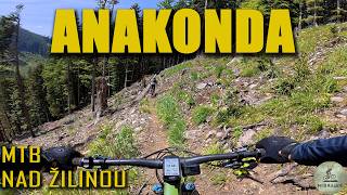
Starý poľovnícky chodník využívaný na cyklistiku, beh a turistiku. Pri zjazde pozor najmä počas víkendov, trail využívajú turisti a bežci ako výstupovú trasu na Minčol. Na chodníku prebehla v roku 2018 masívna ťažba, vďaka čomu bola stredná časť zničená a rozšírená na šírku lesnej cesty.

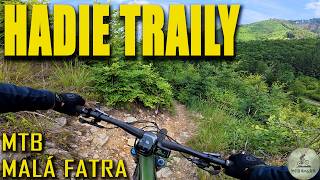
Multi use trail. Be careful while riding down, trail is used by hikers and trails runners.

This trail is unsanctioned.

Disclaimer

Starý poľovnícky chodník využívaný na cyklistiku, beh a turistiku.

Recent Activity on Trail

Past Week
  • 2 rides
  • 21 miles average
6 Months
  • 20 rides
  • 19 miles avg distance
All
  • 209 rides
  • Last: Jun 25, 2026
c1c2c3c4
January
February
March
April
May
June
July
August
September
October
November
December
update trails status or condition

Anakonda Trail Reports

statusdatedescription
Jun 18, 2026 @ 6:06pm (Europe/Bratislava)
Jun 18, 2026
Niektoré časti ešte mokré, ale celkovo fajn. Trávu práve nejaký borec kosil, za čo je veľká vďaka 👍 na konci sa to už dá zísť na...
Jun 10, 2026 @ 10:50am (Europe/Bratislava)
Jun 10, 2026
high grass limits visionat the moment so you have to be careful. The end of the trail now ends with a steep chute that is not meant to be ridden....
May 30, 2026 @ 3:16pm (Europe/Bratislava)
May 30, 2026
všetko ok, mierne vlhko v tieni
May 16, 2026 @ 12:48pm (Europe/Bratislava)
May 16, 2026
Mokro ale fajne
May 4, 2026 @ 4:04pm (Europe/Bratislava)
May 4, 2026
more »
Status:
on Jun 18, 2026
Variable
Avg: 4.34 (19 votes)
Your vote: 0

view (1,738)
close
3D
Trail Conditions
  • Unknown
  • Snow Groomed
  • Snow Packed
  • Snow Covered
  • Snow Cover Partial
  • Freeze/thaw Cycle
  • Icy
  • Prevalent Mud
  • Wet
  • Variable
  • Ideal
  • Dry
  • Very Dry
Trail Flow (Ridden Direction)
Trailforks scans users ridelogs to determine the most popular direction each trail is ridden. A good flowing trail network will have most trails flowing in a single direction according to their intension.
The colour categories are based on what percentage of riders are riding a trail in its intended direction.
  • > 96%
  • > 90%
  • > 80%
  • > 70%
  • > 50%
  • < 50%
  • bi-directional trail
  • no data
Trail Last Ridden
Trailforks scans ridelogs to determine the last time a trail was ridden.
  • < 2 days
  • < 1 week
  • < 2 weeks
  • < 1 month
  • < 6 months
  • > 6 months
Trail Ridden Direction
The intended direction a trail should be ridden.
  • Downhill Only
  • Downhill Primary
  • Both Directions
  • Uphill Primary
  • Uphill Only
  • One Direction
Contribute Details
Colors indicate trail is missing specified detail.
  • Description
  • Photos
  • Description & Photos
  • Videos
Trail Popularity ?
Trailforks scans ridelogs to determine which trails are ridden the most in the last 9 months. Trails are compared with nearby trails in the same city region with a possible 25 colour shades. Think of this as a heatmap, more rides = more kinetic energy = warmer colors.
  • most popular
  • popular
  • less popular
  • not popular
ATV/ORV/OHV Filter
Max Vehicle Width
inches
US Cell Coverage
Legend
cell carrier legend

Radar Time
Activity Recordings
Trailforks uses anonymized public activity data. ?
Activity Recordings
Trailforks uses anonymized public activity data. ?
Personal Heatmap
Activity Types
all / none
Options
2
Date range month
Winter Trails
Warning A routing network for winter maps does not exist. Selecting trails using the winter trails layer has been disabled.
Missing Trails
Most Popular
Least Popular
Trails are colored based on popularity. The more popular a trail is, the more red. Less popular trails trend towards green.
Jump Magnitude Heatmap
Heatmap of where riders jump on trails. Zoom in to see individual jumps, click circles to view jump details.
BC Backroad Status

Service Road Atlas is a free to use, community-driven service for viewing and creating reports on the numerous back-country service roads around B.C. and Alberta.

map legend
Slope Aspect
Direction the slope faces
Flat N NE E SE S SW W NW
Trails Deemphasized
Trails are shown in grey.
disable
Only show trails with no bike usage.
Enable
Suggested Layers
Based on selected activity type

    Save the current map location and zoom level as your default home location whenever this page is loaded.

    Save
        Directions to anakonda trailhead (49.132340, 18.811990)

        Photos

        81 more »
        652 |
        Sep 12, 2016 @ 7:28am
        Sep 12, 2016
        524 |
        Sep 12, 2016 @ 7:29am
        Sep 12, 2016
        86 |
        Sep 22, 2023 @ 12:11pm
        Sep 22, 2023
        165 |
        Apr 10, 2023 @ 11:14am
        Apr 10, 2023

        Videos

        6 more »
        trail Anakonda nad Žilinou, jeden z Hadích...
        11:44 | 56 | Jan 6, 2026 , Žilina
        Ako to vyzerá na Hadích trailoch nad...
        27:03 | 40 | Jan 6, 2026 , Žilina
        Hadie traily
        5:54 | 567 | Apr 22, 2022 , Žilina
        Anakonda
        5:39 | 1883 | Oct 9, 2016 , Žilina

        Routes with this trail

        10 miles 2,061 ft 14
        Na pekne slnecne popolodnie...
        5.0 20 miles 3,978 ft 4 Race
        Visnove Enduro race 16.6.2019

        Reviews / Comments

        No reviews yet, be the first to write a review or ask a question.
        Use trail reports to comment on trail conditions.


        We hope you've been enjoying Trailforks!

        Create a FREE account to view trail comments and much more.

        Nearby Trails

        • #50187 - 32,169 views

        Frequently Asked Questions About Anakonda

        Where is Anakonda located?
        Anakonda is located in Minčol, Žilina, Slovakia. It is part of the Minčol trail network. The trailhead is located at coordinates 49.13234, 18.81199.
        How hard is Anakonda?
        Anakonda is rated as Blue difficulty. The physical rating is Hard. The average grade is 9.995%. The climb difficulty is rated Green.
        What is the elevation gain for Anakonda?
        Anakonda has 90 m of elevation gain. The trail has 447 m of elevation descent. The elevation ranges from 568 m to 925 m.
        Is Anakonda a point to point trail?
        Anakonda is not a point to point trail. The direction is Downhill Primary. The trail type is singletrack.

        Hit the Trail

        Open in App

        Get this trail on your phone instantly.
        open trail in app

        Download Trail

        Save to wishlist, Garmin & download.
        save the trail

        Find Related Routes

        Find routes and users activities that include this trail.
        find routes for this trail

        You must enter a description before submitting.