more stats
14.3 miles
Distance
1,736 ft
Climb
-281 ft
Descent
01:20:37
Avg time
1,454 ft
Altitude change
3,929 ft
Altitude min
5,496 ft
Altitude max
3,985 ft
Altitude start
5,440 ft
Altitude end
1.9%
Grade
-8.8%
Grade max
36.4%
Grade min
10 miles
Distance climb
3 miles
Distance down
1 mile
Distance flat
01:20:37
Avg time

Arnold Ice Cave Details

  • Activities
    • Mountain Bike
    • Adaptive Bike
    • Horse
    • Hike
    • Trail Running
  • Riding Area
    Horse Butte
    Bend, Oregon
  • Ref Number
    #3963
  • Difficulty Rating
  • Local Popularity
    5 in Mountain Biking [+]
    • 5 in Trail Running
    • 5 in Hiking
    • 5 in Horseback
  • Global Ranking
    #127582 in Mountain Biking [+]
    • #137468 in Trail Running
    • #131452 in Hiking
  • Hiking SAC Scale
    T1 Hiking
  • Trail Type
    Singletrack
  • Bike Type
  • Direction
    Both Directions
  • Climb Difficulty
    Blue
  • Physical Rating
    Moderate
  • Dogs Allowed
    Yes
  • eBike Allowed

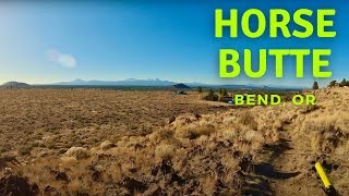
Arnold Ice Cave Trail runs from Horse Butte trailhead all the way out to Swamp Wells Horse Camp.

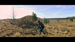
Bunch grass, sagebrush and hidden rocks make for a narrow tread — with the trail getting more remote as you get farther from Horse Butte. The trail starts in the tree cover, and ends in tree cover — but the vast majority of the trail has open views all around. There are some rocky bits along the way with the most challenging portion being a short switchback climb up a ridge just before mile 3.

The first intersection on this trail is with Boyd Cave Trail around mile 4. Many people ride a 10 mile loop connecting Arnold Ice Cave, Boyd Cave, Coyote Loop Trail, and Swamp Wells.

The second intersection is with Horse to Horse which will take you out to the Horse Ridge riding area. From this intersection the trail has no other intersections until you reach the Horse Camp. From the camp you have the option of heading back to Horse Butte by way of Coyote Loop, or Swamp Wells.

Adaptive Bike Info
aMTB Green Rating: Beginner features and moderate terrain.

First 4 miles were assessed for aMTB use. Check out the horse butte loop (https://www.trailforks.com/route/horse-butte-loop/) aMTB rating is provided for general information only and may not reflect the technical difficulty of the trail or a particular rider's support needs. COTA completed a trail assessment process, please find more information on our website: https://www.cotamtb.com/amtb-trail-information.html. Contact Oregon Adaptive Sports for more information or ride support: https://oregonadaptivesports.org.

Trail Supporters

  • USFS
    Land Manager

Recent Activity on Trail

Past Week
  • 0 rides
  •  
6 Months
  • 0 rides
  •  
All
  • 50 rides
  • Last: Apr 30, 2025
c1c2c3c4
January
February
March
April
May
June
July
August
September
October
November
December
update trails status or condition

Arnold Ice Cave Trail Reports

statusdatedescription
Apr 19, 2026 @ 6:16pm (America/Los_Angeles)
Apr 19, 2026
Drove in through Milican Valley to ride this since I was missing getting lost in the woods in this part of the forest. Parked at Arnold Ice Cave....
May 7, 2025 @ 12:13pm
May 7, 2025
reporter The Deschutes National Forest will temporarily close the Cabin Butte Vegetation Management Project area south of Bend, Oregon, beginning May 1, to...
Apr 27, 2025 @ 7:41am
Apr 27, 2025
As good as it gets. Go get it before it closes. A few small snow patches near the horse camp.
Jul 11, 2024 @ 8:15am
Jul 11, 2024
Apr 30, 2023 @ 9:50pm
Apr 30, 2023
I went up Coyote to Swamp Wells Horse Camp and down Arnold Ice Cave trail. The top still had some decent size patches of snow. Most of them I...
more »
Status:
on Apr 19, 2026
Avg: 3.65 (3 votes)
Your vote: 0

view (240)
close
3D
Trail Conditions
  • Unknown
  • Snow Groomed
  • Snow Packed
  • Snow Covered
  • Snow Cover Partial
  • Freeze/thaw Cycle
  • Icy
  • Prevalent Mud
  • Wet
  • Variable
  • Ideal
  • Dry
  • Very Dry
Trail Flow (Ridden Direction)
Trailforks scans users ridelogs to determine the most popular direction each trail is ridden. A good flowing trail network will have most trails flowing in a single direction according to their intension.
The colour categories are based on what percentage of riders are riding a trail in its intended direction.
  • > 96%
  • > 90%
  • > 80%
  • > 70%
  • > 50%
  • < 50%
  • bi-directional trail
  • no data
Trail Last Ridden
Trailforks scans ridelogs to determine the last time a trail was ridden.
  • < 2 days
  • < 1 week
  • < 2 weeks
  • < 1 month
  • < 6 months
  • > 6 months
Trail Ridden Direction
The intended direction a trail should be ridden.
  • Downhill Only
  • Downhill Primary
  • Both Directions
  • Uphill Primary
  • Uphill Only
  • One Direction
Contribute Details
Colors indicate trail is missing specified detail.
  • Description
  • Photos
  • Description & Photos
  • Videos
Trail Popularity ?
Trailforks scans ridelogs to determine which trails are ridden the most in the last 9 months. Trails are compared with nearby trails in the same city region with a possible 25 colour shades. Think of this as a heatmap, more rides = more kinetic energy = warmer colors.
  • most popular
  • popular
  • less popular
  • not popular
ATV/ORV/OHV Filter
Max Vehicle Width
inches
US Cell Coverage
Legend
cell carrier legend

Radar Time
Activity Recordings
Trailforks uses anonymized public activity data. ?
Activity Recordings
Trailforks uses anonymized public activity data. ?
Personal Heatmap
Activity Types
all / none
Options
2
Date range month
Winter Trails
Warning A routing network for winter maps does not exist. Selecting trails using the winter trails layer has been disabled.
Missing Trails
Most Popular
Least Popular
Trails are colored based on popularity. The more popular a trail is, the more red. Less popular trails trend towards green.
Jump Magnitude Heatmap
Heatmap of where riders jump on trails. Zoom in to see individual jumps, click circles to view jump details.
BC Backroad Status

Service Road Atlas is a free to use, community-driven service for viewing and creating reports on the numerous back-country service roads around B.C. and Alberta.

map legend
Slope Aspect
Direction the slope faces
Flat N NE E SE S SW W NW
Trails Deemphasized
Trails are shown in grey.
disable
Only show trails with no bike usage.
Enable
Suggested Layers
Based on selected activity type

    Save the current map location and zoom level as your default home location whenever this page is loaded.

    Save
        Directions to arnold-ice-cave trailhead (43.977430, -121.234320)

        Photos

        49 more »
        52 |
        Jul 11, 2024 @ 8:36am
        Jul 11, 2024
        41 |
        Jul 11, 2024 @ 8:36am
        Jul 11, 2024
        41 |
        Jul 11, 2024 @ 8:36am
        Jul 11, 2024
        46 |
        Jul 11, 2024 @ 8:35am
        Jul 11, 2024

        Videos

        2 more »
        Mountain Biking Horse Butte - Bend, Oregon
        8:00 | 594 | Jan 9, 2022 , Bend
        MTB Oregon ep 3
        0:18 | 468 | Feb 29, 2020 , Bend

        Routes with this trail

        2.7 26 miles 1,951 ft 5
        Great loop for early/late season. Often good to go before most of lower Phil's.

        Trail Products

        2 Reviews & Comments


        We hope you've been enjoying Trailforks!

        Create a FREE account to view trail comments and much more.

        • By cringeTF Pro & contributors
        • #86354 - 4,550 views

        Frequently Asked Questions About Arnold Ice Cave

        Where is Arnold Ice Cave located?
        Arnold Ice Cave is located in Horse Butte, Bend, Oregon, United States. It is part of the Horse Butte trail network. The trailhead is located at coordinates 43.97743, -121.23432.
        How hard is Arnold Ice Cave?
        Arnold Ice Cave is rated as Blue difficulty. The physical rating is Moderate. The average grade is 1.9%. The climb difficulty is rated Blue.
        What is the elevation gain for Arnold Ice Cave?
        Arnold Ice Cave has 1,736 ft of elevation gain. The trail has 281 ft of elevation descent. The elevation ranges from 3,929 ft to 5,496 ft.
        Is Arnold Ice Cave a point to point trail?
        Arnold Ice Cave is not a point to point trail. The direction is Both Directions. The trail type is singletrack.

        Hit the Trail

        Open in App

        Get this trail on your phone instantly.
        open trail in app

        Download Trail

        Save to wishlist, Garmin & download.
        save the trail

        Find Related Routes

        Find routes and users activities that include this trail.
        find routes for this trail

        You must enter a description before submitting.