more stats
4.7 miles
Distance
757 ft
Climb
-581 ft
Descent
00:43:03
Avg time
175 ft
Altitude change
7,830 ft
Altitude min
8,261 ft
Altitude max
7,831 ft
Altitude start
8,005 ft
Altitude end
0.7%
Grade
-32.6%
Grade max
26.6%
Grade min
2 miles
Distance climb
2 miles
Distance down
1 mile
Distance flat
00:43:03
Avg time

Arrow Details

  • Activities
    • Mountain Bike
    • Hike
    • Trail Running
  • Riding Area
    Teton Pass
    Wilson, Wyoming
  • Difficulty Rating
  • Local Popularity
    75 in Mountain Biking [+]
    • 45 in Trail Running
    • 70 in Hiking
  • Global Ranking
    #44832 in Mountain Biking [+]
    • #117828 in Trail Running
    • #76113 in Hiking
  • Trail Type
    Singletrack
  • Direction
    Both Directions
    Popular Direction Shown
  • Climb Difficulty
    Blue
  • Physical Rating
    Moderate
  • Dogs Allowed
    Yes
  • eBike Allowed
  • Land Owner

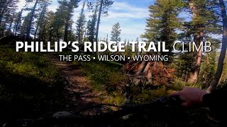
This trail was built in 2008 in 1 week by 1000 Boy Scouts. It is meant to provide access to Phillip's Canyon for mountain bikers. It is managed as hike and bike only and parallels the Phillip's Pass Trail above it which is managed for horse and hike only.

Access Info

This trail can be accessed from the Phillip's Trailhead.

Trail Supporters
Local Trail Association
Traditionally Indigenous Territory

Recent Activity on Trail

Past Week
  • 0 rides
  •  
6 Months
  • 2 rides
  • 9 miles avg distance
All
  • 205 rides
  • Last: Jun 17, 2026
c1c2c3c4
January
February
March
April
May
June
July
August
September
October
November
December
update trails status or condition

Arrow Trail Reports

statusdatedescription
Apr 23, 2026 @ 9:44am (America/Denver)
Apr 23, 2026
Oct 22, 2025 @ 7:04pm (America/Denver)
Oct 22, 2025
Oct 3, 2025 @ 2:25pm (America/Denver)
Oct 3, 2025
Jun 30, 2025 @ 6:48pm
Jun 30, 2025
Small tree across the trail on upper switchbacks.
Aug 26, 2024 @ 8:50am
Aug 26, 2024
Large tree (18-24" diameter) across lower section of Arrow between road and start of Philips Ridge.
more »
Status:
on Apr 23, 2026
Snow Cover Partial
Avg: 4.14 (15 votes)
Your vote: 0

view (1,351)
close
3D
Trail Conditions
  • Unknown
  • Snow Groomed
  • Snow Packed
  • Snow Covered
  • Snow Cover Partial
  • Freeze/thaw Cycle
  • Icy
  • Prevalent Mud
  • Wet
  • Variable
  • Ideal
  • Dry
  • Very Dry
Trail Flow (Ridden Direction)
Trailforks scans users ridelogs to determine the most popular direction each trail is ridden. A good flowing trail network will have most trails flowing in a single direction according to their intension.
The colour categories are based on what percentage of riders are riding a trail in its intended direction.
  • > 96%
  • > 90%
  • > 80%
  • > 70%
  • > 50%
  • < 50%
  • bi-directional trail
  • no data
Trail Last Ridden
Trailforks scans ridelogs to determine the last time a trail was ridden.
  • < 2 days
  • < 1 week
  • < 2 weeks
  • < 1 month
  • < 6 months
  • > 6 months
Trail Ridden Direction
The intended direction a trail should be ridden.
  • Downhill Only
  • Downhill Primary
  • Both Directions
  • Uphill Primary
  • Uphill Only
  • One Direction
Contribute Details
Colors indicate trail is missing specified detail.
  • Description
  • Photos
  • Description & Photos
  • Videos
Trail Popularity ?
Trailforks scans ridelogs to determine which trails are ridden the most in the last 9 months. Trails are compared with nearby trails in the same city region with a possible 25 colour shades. Think of this as a heatmap, more rides = more kinetic energy = warmer colors.
  • most popular
  • popular
  • less popular
  • not popular
ATV/ORV/OHV Filter
Max Vehicle Width
inches
US Cell Coverage
Legend
cell carrier legend

Radar Time
Activity Recordings
Trailforks uses anonymized public activity data. ?
Activity Recordings
Trailforks uses anonymized public activity data. ?
Personal Heatmap
Activity Types
all / none
Options
2
Date range month
Winter Trails
Warning A routing network for winter maps does not exist. Selecting trails using the winter trails layer has been disabled.
Missing Trails
Most Popular
Least Popular
Trails are colored based on popularity. The more popular a trail is, the more red. Less popular trails trend towards green.
Jump Magnitude Heatmap
Heatmap of where riders jump on trails. Zoom in to see individual jumps, click circles to view jump details.
BC Backroad Status

Service Road Atlas is a free to use, community-driven service for viewing and creating reports on the numerous back-country service roads around B.C. and Alberta.

map legend
Slope Aspect
Direction the slope faces
Flat N NE E SE S SW W NW
Trails Deemphasized
Trails are shown in grey.
disable
Only show trails with no bike usage.
Enable
Suggested Layers
Based on selected activity type

    Save the current map location and zoom level as your default home location whenever this page is loaded.

    Save
        Directions to arrow trailhead (43.507400, -110.926830)

        Photos

        25 more »
        103 |
        Aug 5, 2020 @ 9:19am
        Aug 5, 2020
        107 |
        Aug 5, 2020 @ 9:19am
        Aug 5, 2020
        105 |
        Aug 5, 2020 @ 9:19am
        Aug 5, 2020
        119 |
        Sep 26, 2018 @ 5:45pm
        Sep 26, 2018

        Videos

        4 more »
        youtuber Back at Teton Pass on Phillips Canyon! |...
        20:16 | 176 | Oct 3, 2023 , Wilson
        2022 WYORADO - Mountain Biking Wyoming &...
        30:13 | 149 | Sep 21, 2022 , Wilson
        Phillip's Ridge (Climb) Mountain Bike - Wilson...
        45:02 | 141 | Sep 17, 2022 , Wilson
        Bear What? - Biking With Bears...
        6:26 | 409 | Nov 24, 2019 , Wilson

        Routes with this trail

        25 miles 3,632 ft 23 Shuttled
        Shuttle Ride Start at the top of Teton Pass head out on towards . Saddle up and get ready for , this is...
        22 miles 2,828 ft 27 Loop
        The course for the Heels on Wheels Women's Fun-duro in Jackson Hole, Wyoming. This event is put on by JH...
        33 miles 6,163 ft 23
        A variation from the existing Tour de Teton Pass, but all on dirt and no shuttle.

        2 Reviews & Comments


        We hope you've been enjoying Trailforks!

        Create a FREE account to view trail comments and much more.

        • By toddTF Pro Trailforks & contributors
        • #23876 - 4,835 views

        Frequently Asked Questions About Arrow

        Where is Arrow located?
        Arrow is located in Teton Pass, Wilson, Wyoming, United States. It is part of the Teton Pass trail network. The trailhead is located at coordinates 43.5074, -110.92683.
        How hard is Arrow?
        Arrow is rated as Blue difficulty. The physical rating is Moderate. The average grade is 0.7%. The climb difficulty is rated Blue.
        What is the elevation gain for Arrow?
        Arrow has 757 ft of elevation gain. The trail has 581 ft of elevation descent. The elevation ranges from 7,830 ft to 8,261 ft.
        Is Arrow a point to point trail?
        Arrow is not a point to point trail. The direction is Both Directions. The trail type is singletrack.

        Hit the Trail

        Open in App

        Get this trail on your phone instantly.
        open trail in app

        Download Trail

        Save to wishlist, Garmin & download.
        save the trail

        Find Related Routes

        Find routes and users activities that include this trail.
        find routes for this trail

        You must enter a description before submitting.