more stats
2,874 ft
Distance
65 ft
Climb
-297 ft
Descent
00:05:41
Avg time
-232 ft
Altitude change
5,685 ft
Altitude min
5,917 ft
Altitude max
5,917 ft
Altitude start
5,685 ft
Altitude end
-8.076%
Grade
-55.892%
Grade max
25.589%
Grade min
706 ft
Distance climb
2,016 ft
Distance down
152 ft
Distance flat
00:05:41
Avg time

Arrow Details

  • Activities
    • Mountain Bike
    • E-Bike
    • Adaptive Bike
  • Riding Area
    SkyPark at Santa's Village
    Skyforest, California
  • Difficulty Rating
  • Voted Difficulty
    Black Diamond (5 votes)
  • Local Popularity
    90 in Mountain Biking [+]
    • 95 in E-Biking
  • Global Ranking
    #27090 in Mountain Biking [+]
    • #3974 in E-Biking
  • Trail Type
    Singletrack
  • Bike Type
    DH, AM, Adaptive MTB
  • Direction
    Downhill Only
    Popular Direction Shown
  • eBike Allowed
    Yes up to Class 1

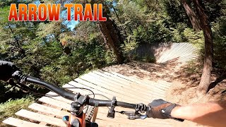
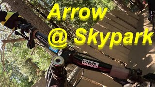
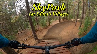
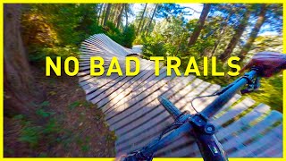
Arrow is Skypark's premiere introductory black diamond trail which features a little bit of everything the park has to offer. You start down a straight with some small rollers leading into a wooden wall ride. The wall ride spits you out into a series of small table top jumps and transitions. The last jump in this section is a step up which goes into a second wall ride which will require a bit more speed than the first. A couple more jumps and you'll be crossing the fire road climb; here you can choose to climb back up to the top or continue down the remainder of arrow. Taking a sharp left off the fire road brings you back onto Arrow and into a bit of single track tech riding. Next up you'll encounter a newer wooden S-feature followed by a wooden bridge descent. There a few more small jumps and features at the bottom of the trail including a sizeable wooden double after which you'll be back in for another climb back to the top.

Adaptive Bike Info
aMTB Black Rating: Advanced obstacles exist, some trail obstructions.

Upper section - (aMTB1x) Ride arounds for everything. Trail narrows near end.
Middle Section - (aMTB3) Extreme wood feature. Advanced riders with support only.
Lower Section - (aMTB1x) Off-camber up-and-over wood feature. Bring spotter first time to scope it.

Bike Park

Traditionally Indigenous Territory

Recent Activity on Trail

Past Week
  • 11 rides
  • 12 miles average
6 Months
  • 101 rides
  • 10 miles avg distance
All
  • 987 rides
  • Last: Jun 12, 2026
c1c2c3c4
January
February
March
April
May
June
July
August
September
October
November
December
Status:
on Jun 9, 2025
Dry
Avg: 4.63 (33 votes)
Your vote: 0

view (30,210)
close
3D
Trail Conditions
  • Unknown
  • Snow Groomed
  • Snow Packed
  • Snow Covered
  • Snow Cover Partial
  • Freeze/thaw Cycle
  • Icy
  • Prevalent Mud
  • Wet
  • Variable
  • Ideal
  • Dry
  • Very Dry
Trail Flow (Ridden Direction)
Trailforks scans users ridelogs to determine the most popular direction each trail is ridden. A good flowing trail network will have most trails flowing in a single direction according to their intension.
The colour categories are based on what percentage of riders are riding a trail in its intended direction.
  • > 96%
  • > 90%
  • > 80%
  • > 70%
  • > 50%
  • < 50%
  • bi-directional trail
  • no data
Trail Last Ridden
Trailforks scans ridelogs to determine the last time a trail was ridden.
  • < 2 days
  • < 1 week
  • < 2 weeks
  • < 1 month
  • < 6 months
  • > 6 months
Trail Ridden Direction
The intended direction a trail should be ridden.
  • Downhill Only
  • Downhill Primary
  • Both Directions
  • Uphill Primary
  • Uphill Only
  • One Direction
Contribute Details
Colors indicate trail is missing specified detail.
  • Description
  • Photos
  • Description & Photos
  • Videos
Trail Popularity ?
Trailforks scans ridelogs to determine which trails are ridden the most in the last 9 months. Trails are compared with nearby trails in the same city region with a possible 25 colour shades. Think of this as a heatmap, more rides = more kinetic energy = warmer colors.
  • most popular
  • popular
  • less popular
  • not popular
ATV/ORV/OHV Filter
Max Vehicle Width
inches
US Cell Coverage
Legend
cell carrier legend

Radar Time
Activity Recordings
Trailforks uses anonymized public activity data. ?
Activity Recordings
Trailforks uses anonymized public activity data. ?
Personal Heatmap
Activity Types
all / none
Options
2
Date range month
Winter Trails
Warning A routing network for winter maps does not exist. Selecting trails using the winter trails layer has been disabled.
Missing Trails
Most Popular
Least Popular
Trails are colored based on popularity. The more popular a trail is, the more red. Less popular trails trend towards green.
Jump Magnitude Heatmap
Heatmap of where riders jump on trails. Zoom in to see individual jumps, click circles to view jump details.
BC Backroad Status

Service Road Atlas is a free to use, community-driven service for viewing and creating reports on the numerous back-country service roads around B.C. and Alberta.

map legend
Slope Aspect
Direction the slope faces
Flat N NE E SE S SW W NW
Trails Deemphasized
Trails are shown in grey.
disable
Only show trails with no bike usage.
Enable
Suggested Layers
Based on selected activity type

    Save the current map location and zoom level as your default home location whenever this page is loaded.

    Save
        Directions to arrow-108059 trailhead (34.231368, -117.165700)

        Photos

        5 more »
        125 |
        Aug 20, 2023 @ 6:31am
        Aug 20, 2023
        239 |
        Jul 18, 2020 @ 10:12am
        Jul 18, 2020
        200 |
        Jul 1, 2019 @ 6:22pm
        Jul 1, 2019
        380 |
        Aug 13, 2018 @ 11:14am
        Aug 13, 2018

        Videos

        21 more »
        youtuber Arrow Trail - SkyPark Bike Park - Mountain Biking
        2:54 | 218 | Jul 16, 2024 , Skyforest
        youtuber Arrow Trail Skypark Mountain Biking 2023
        8:24 | 227 | Oct 12, 2023 , Skyforest
        youtuber SkyPark at Santa's Village
        16:31 | 87 | May 16, 2025 , Skyforest
        youtuber Every Skypark Trail - Newest Updates and Full...
        22:07 | 83 | Nov 13, 2024 , Skyforest

        Routes with this trail

        1,348 ft 1
        just the upper section of arrow
        2,949 ft 110 ft 5 Loop
        Quick lap on Upper Arrow if you don't want to go all the way to the bottom. Adaptive Riders: All bridges...
        1 mile 241 ft 17 Loop
        Popular trail combo. Instead of taking from Sleigh Ride, use the Lower Connector off of to access Lower...

        2 Reviews & Comments


        We hope you've been enjoying Trailforks!

        Create a FREE account to view trail comments and much more.

        • By toddTF Pro Trailforks & contributors
        • #108059 - 5,440 views

        Frequently Asked Questions About Arrow

        Where is Arrow located?
        Arrow is located in SkyPark at Santa's Village, Skyforest, California, United States. It is part of the SkyPark at Santa's Village trail network. The trailhead is located at coordinates 34.23137, -117.1657.
        How hard is Arrow?
        Arrow is rated as Black Diamond difficulty. The average grade is 8.076%.
        What is the elevation gain for Arrow?
        Arrow has 20 m of elevation gain. The trail has 91 m of elevation descent. The elevation ranges from 1,733 m to 1,804 m.
        Is Arrow a point to point trail?
        Yes, Arrow is a point to point trail. The direction is Downhill Only. The trail type is singletrack.

        Hit the Trail

        Open in App

        Get this trail on your phone instantly.
        open trail in app

        Download Trail

        Save to wishlist, Garmin & download.
        save the trail

        Find Related Routes

        Find routes and users activities that include this trail.
        find routes for this trail

        You must enter a description before submitting.