more stats
1.0 mile
Distance
512 ft
Climb
-26 ft
Descent
00:15:37
Avg time
488 ft
Altitude change
1,182 ft
Altitude min
1,670 ft
Altitude max
1,182 ft
Altitude start
1,670 ft
Altitude end
9%
Grade
-21.9%
Grade max
63.5%
Grade min
3,947 ft
Distance climb
397 ft
Distance down
935 ft
Distance flat
00:15:37
Avg time

As You Do Details

  • Activities
    • Mountain Bike
    • E-Bike
    • Hike
    • Trail Running
  • Riding Area
  • AKA
    Ornament Trail
  • Difficulty Rating
  • Local Popularity
    75 in Mountain Biking [+]
    • 75 in E-Biking
    • 90 in Trail Running
    • 80 in Hiking
  • Global Ranking
    #26544 in Mountain Biking [+]
    • #34231 in E-Biking
    • #19992 in Trail Running
    • #38366 in Hiking
  • Hiking SAC Scale
    T1 Hiking
  • Trail Type
    Singletrack
  • Bike Type
    XC
  • Direction
    Uphill Only
    Popular Direction Shown
  • Climb Difficulty
    Blue
  • Physical Rating
    Hard
  • Dogs Allowed
    Yes
  • eBike Allowed
    Yes up to Class 1
  • Ride in Rain
    Yes

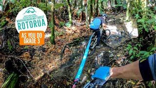
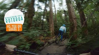
This trail is shared with walkers and is uphill-only for mountainbikers. The initial section is rolling, through mainly eucalypt forest, with twists and turns and occasional roots. Then after the junction with the end of Box of Birds Trail it climbs steadily, with some pinch climbs and rooty patches to keep you on your toes, and enters a long gully where the forest changes to native species and the occasional pine. Watch for the little ornaments hidden at various points alongside the track. The trail then crosses Tokorangi Pa Road and continues climbing through Douglas Fir and eucalypts, and finishes at a link road joining Tokorangi Pa and Katore Roads.

Access Info

The easiest way to find the start of this trail is to ride from Longmile Ave up the grass berm on the right-hand side of Tarawera Rd until Selwyn Rd intersection, then turn right from the gravel carpark to enter the forest on the Waitawa Link walking track. A few metres after entering the forest turn left onto the trail crossing Waitawa Link and follow this for around 100 metres until you get to the As You Do sign on your right.

Local Trail Association

Recent Activity on Trail

Past Week
  • 4 rides
  • 18 miles average
6 Months
  • 134 rides
  • 15 miles avg distance
All
  • 1,029 rides
  • Last: Jun 20, 2026
c1c2c3c4
January
February
March
April
May
June
July
August
September
October
November
December
update trails status or condition

As You Do Trail Reports

statusdatedescription
Jun 13, 2026 @ 2:24pm (Pacific/Auckland)
Jun 12, 2026
Jun 5, 2026 @ 1:59pm (Pacific/Auckland)
Jun 4, 2026
reporter Tree across track reported friday morning cleared by RTT
Jun 3, 2026 @ 5:53pm (Pacific/Auckland)
Jun 2, 2026
tree cleared by the RTT legends
Jun 3, 2026 @ 10:56am (Pacific/Auckland)
Jun 2, 2026
Large tree down across trail, blocking trail for bikes - can get through with a squeeze walking at least. Big chainsaw job
May 29, 2026 @ 11:33am (Pacific/Auckland)
May 28, 2026
more »
Status:
on Jun 13, 2026
Ideal
Avg: 3.7 (14 votes)
Your vote: 0

view (9,106)
close
3D
Trail Conditions
  • Unknown
  • Snow Groomed
  • Snow Packed
  • Snow Covered
  • Snow Cover Partial
  • Freeze/thaw Cycle
  • Icy
  • Prevalent Mud
  • Wet
  • Variable
  • Ideal
  • Dry
  • Very Dry
Trail Flow (Ridden Direction)
Trailforks scans users ridelogs to determine the most popular direction each trail is ridden. A good flowing trail network will have most trails flowing in a single direction according to their intension.
The colour categories are based on what percentage of riders are riding a trail in its intended direction.
  • > 96%
  • > 90%
  • > 80%
  • > 70%
  • > 50%
  • < 50%
  • bi-directional trail
  • no data
Trail Last Ridden
Trailforks scans ridelogs to determine the last time a trail was ridden.
  • < 2 days
  • < 1 week
  • < 2 weeks
  • < 1 month
  • < 6 months
  • > 6 months
Trail Ridden Direction
The intended direction a trail should be ridden.
  • Downhill Only
  • Downhill Primary
  • Both Directions
  • Uphill Primary
  • Uphill Only
  • One Direction
Contribute Details
Colors indicate trail is missing specified detail.
  • Description
  • Photos
  • Description & Photos
  • Videos
Trail Popularity ?
Trailforks scans ridelogs to determine which trails are ridden the most in the last 9 months. Trails are compared with nearby trails in the same city region with a possible 25 colour shades. Think of this as a heatmap, more rides = more kinetic energy = warmer colors.
  • most popular
  • popular
  • less popular
  • not popular
ATV/ORV/OHV Filter
Max Vehicle Width
inches
US Cell Coverage
Legend
cell carrier legend

Radar Time
Activity Recordings
Trailforks uses anonymized public activity data. ?
Activity Recordings
Trailforks uses anonymized public activity data. ?
Personal Heatmap
Activity Types
all / none
Options
2
Date range month
Winter Trails
Warning A routing network for winter maps does not exist. Selecting trails using the winter trails layer has been disabled.
Missing Trails
Most Popular
Least Popular
Trails are colored based on popularity. The more popular a trail is, the more red. Less popular trails trend towards green.
Jump Magnitude Heatmap
Heatmap of where riders jump on trails. Zoom in to see individual jumps, click circles to view jump details.
BC Backroad Status

Service Road Atlas is a free to use, community-driven service for viewing and creating reports on the numerous back-country service roads around B.C. and Alberta.

map legend
Slope Aspect
Direction the slope faces
Flat N NE E SE S SW W NW
Trails Deemphasized
Trails are shown in grey.
disable
Only show trails with no bike usage.
Enable
Suggested Layers
Based on selected activity type

    Save the current map location and zoom level as your default home location whenever this page is loaded.

    Save
        Directions to as-you-do trailhead (-38.154380, 176.287820)

        Photos

        162 more »
        33 |
        May 16, 2019 @ 7:29pm
        May 16, 2019
        59 |
        Jun 13, 2018 @ 1:47pm
        Jun 13, 2018
        79 |
        Mar 10, 2018 @ 2:21am
        Mar 10, 2018
        83 |
        Mar 10, 2018 @ 2:11am
        Mar 10, 2018

        Videos

        4 more »
        youtuber The best riding loop in Rotorua?  ::  As You...
        9:18 | 737 | Mar 29, 2020 , Rotorua
        youtuber The MTB Uphill Challenge You’ll Actually Enjoy
        17:36 | 76 | Oct 20, 2025 , Rotorua
        youtuber Climbing Tethered to your mate - As You Do,...
        14:21 | 331 | Jun 22, 2022 , Rotorua
        As You Do, Rotorua - Straight to the TOP
        5:27 | 473 | Aug 22, 2019 , Rotorua

        Trail Lists

        Routes with this trail

        4.0 22 miles 3,198 ft 49 Loop
        This is a huge ride that our friends at Bike Culture helped create. If you are looking for a challenging...
        3.0 16 miles 2,978 ft 37 Loop
        This is another great loop that the locals enjoy. Expect a fun day in the saddle while you ride some of...
        59 miles 9,388 ft 63 Loop
        Whaka100 20233

        3 Reviews & Comments


        We hope you've been enjoying Trailforks!

        Create a FREE account to view trail comments and much more.

        Frequently Asked Questions About As You Do

        Where is As You Do located?
        As You Do is located in Whakarewarewa Forest, Rotorua, New Zealand. It is part of the Whakarewarewa Forest trail network. The trailhead is located at coordinates -38.15438, 176.28782.
        How hard is As You Do?
        As You Do is rated as Advanced difficulty. The physical rating is Hard. The average grade is 9%. The climb difficulty is rated Blue.
        What is the elevation gain for As You Do?
        As You Do has 512 ft of elevation gain. The trail has 26 ft of elevation descent. The elevation ranges from 1,182 ft to 1,670 ft.
        Is As You Do a point to point trail?
        Yes, As You Do is a point to point trail. The direction is Uphill Only. The trail type is singletrack.

        Hit the Trail

        Open in App

        Get this trail on your phone instantly.
        open trail in app

        Download Trail

        Save to wishlist, Garmin & download.
        save the trail

        Find Related Routes

        Find routes and users activities that include this trail.
        find routes for this trail

        You must enter a description before submitting.