more stats
1.9 miles
Distance
10 ft
Climb
-1,084 ft
Descent
00:17:45
Avg time
-1,074 ft
Altitude change
7,951 ft
Altitude min
9,025 ft
Altitude max
9,025 ft
Altitude start
7,949 ft
Altitude end
-11%
Grade
-52.2%
Grade max
6.2%
Grade min
564 ft
Distance climb
2 miles
Distance down
427 ft
Distance flat
00:17:45
Avg time

Aspen Draw Details

  • Activities
    • Mountain Bike
    • Horse
    • Hike
    • Trail Running
  • Riding Area
    Mt Lemmon - Upper
    Tucson, Arizona
  • Difficulty Rating
  • Voted Difficulty
    Black Diamond (3 votes)
  • Local Popularity
    90 in Mountain Biking [+]
    • 90 in Trail Running
    • 85 in Hiking
    • 5 in Horseback
  • Global Ranking
    #10268 in Mountain Biking [+]
    • #35041 in Trail Running
    • #50616 in Hiking
  • Trail Type
    Singletrack
  • Bike Type
    DH, AM
  • Direction
    Downhill Primary
    Popular Direction Shown
  • Physical Rating
    Moderate
  • Season
    March-Nov
  • eBike Allowed
  • Land Owner
    Coronado National Forest

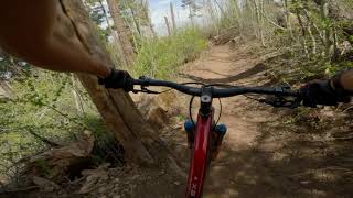
This is Tucson's true downhill trail. A favorite of those looking for a multi shuttle day with easy road access and zero climbing. Its a great high elevation escape from the heat loaded with awesome tree lined singletrack. Throw in some slick roots and rock gardens leaving yourself the perfect ingredients for fun. Its nickname is Aspirin Draw.

*WARNING* Highly used multi-use trail with heavy hiker traffic on weekends.

Access Info

This trail is accessed from the Ski Run Rd. You enter in on the access rd for the ski lifts. Trail is marked just past the ski lifts on your left by maintenance shed.

Trail Supporters
  • Tucson Off-road Cyclists and Activists
    Sponsor

  • USFS
    Land Manager
Local Trail Association

Recent Activity on Trail

Past Week
  • 6 rides
  • 12 miles average
6 Months
  • 29 rides
  • 16 miles avg distance
All
  • 273 rides
  • Last: Jun 16, 2026
c1c2c3c4
January
February
March
April
May
June
July
August
September
October
November
December
update trails status or condition

Aspen Draw Trail Reports

statusdatedescription
Mar 14, 2026 @ 7:54am (America/Phoenix)
Mar 14, 2026
4 down trees as of mid march
May 2, 2025 @ 11:18pm
May 2, 2025
One or two trees down on Lemmon Drop on each trail from Aspen Draw down to Greens. Trails are dry and pretty loose. Greens was burlier than I...
Apr 26, 2025 @ 9:42am
Apr 26, 2025
Fast and fun. A few hikers who appear to be stunned when you come from nowhere.
Sep 8, 2024 @ 6:30am
Sep 8, 2024
All trees have been cleared. Ferns are pretty tall though so be careful not to startle any hikers.
Jun 16, 2024 @ 12:34am
Jun 16, 2024
more »
Status:
on Mar 14, 2026
Dry
Avg: 4.48 (21 votes)
Your vote: 0

view (3,112)
close
3D
Trail Conditions
  • Unknown
  • Snow Groomed
  • Snow Packed
  • Snow Covered
  • Snow Cover Partial
  • Freeze/thaw Cycle
  • Icy
  • Prevalent Mud
  • Wet
  • Variable
  • Ideal
  • Dry
  • Very Dry
Trail Flow (Ridden Direction)
Trailforks scans users ridelogs to determine the most popular direction each trail is ridden. A good flowing trail network will have most trails flowing in a single direction according to their intension.
The colour categories are based on what percentage of riders are riding a trail in its intended direction.
  • > 96%
  • > 90%
  • > 80%
  • > 70%
  • > 50%
  • < 50%
  • bi-directional trail
  • no data
Trail Last Ridden
Trailforks scans ridelogs to determine the last time a trail was ridden.
  • < 2 days
  • < 1 week
  • < 2 weeks
  • < 1 month
  • < 6 months
  • > 6 months
Trail Ridden Direction
The intended direction a trail should be ridden.
  • Downhill Only
  • Downhill Primary
  • Both Directions
  • Uphill Primary
  • Uphill Only
  • One Direction
Contribute Details
Colors indicate trail is missing specified detail.
  • Description
  • Photos
  • Description & Photos
  • Videos
Trail Popularity ?
Trailforks scans ridelogs to determine which trails are ridden the most in the last 9 months. Trails are compared with nearby trails in the same city region with a possible 25 colour shades. Think of this as a heatmap, more rides = more kinetic energy = warmer colors.
  • most popular
  • popular
  • less popular
  • not popular
ATV/ORV/OHV Filter
Max Vehicle Width
inches
US Cell Coverage
Legend
cell carrier legend

Radar Time
Activity Recordings
Trailforks uses anonymized public activity data. ?
Activity Recordings
Trailforks uses anonymized public activity data. ?
Personal Heatmap
Activity Types
all / none
Options
2
Date range month
Winter Trails
Warning A routing network for winter maps does not exist. Selecting trails using the winter trails layer has been disabled.
Missing Trails
Most Popular
Least Popular
Trails are colored based on popularity. The more popular a trail is, the more red. Less popular trails trend towards green.
Jump Magnitude Heatmap
Heatmap of where riders jump on trails. Zoom in to see individual jumps, click circles to view jump details.
BC Backroad Status

Service Road Atlas is a free to use, community-driven service for viewing and creating reports on the numerous back-country service roads around B.C. and Alberta.

map legend
Slope Aspect
Direction the slope faces
Flat N NE E SE S SW W NW
Trails Deemphasized
Trails are shown in grey.
disable
Only show trails with no bike usage.
Enable
Suggested Layers
Based on selected activity type

    Save the current map location and zoom level as your default home location whenever this page is loaded.

    Save
        Directions to aspen-draw trailhead (32.441650, -110.780460)

        Photos

        36 more »
        69 |
        Dec 13, 2024 @ 10:49pm
        Dec 13, 2024
        260 |
        May 23, 2020 @ 1:38pm
        May 23, 2020
        190 |
        May 23, 2020 @ 1:38pm
        May 23, 2020
        206 |
        May 23, 2020 @ 1:38pm
        May 23, 2020

        Videos

        3 more »
        Best Trail in Tucson - Aspen Draw
        0:36 | 419 | May 7, 2023 , Tucson
        Amazing downhill after the rain | Aspen Draw...
        6:37 | 1064 | Jul 7, 2021 , Tucson
        A day on aspen
        4:02 | 533 | Aug 1, 2017 , Tucson

        Routes with this trail

        3.6 31 miles 3,652 ft 13 Shuttled
        This is it, the real deal, the full Lemmon Drop. Its a 35mile punch in the face that will leave you...
        27 miles 1,411 ft 10
        This route starts at the chair lift on the tip top of Mount Lemmon in Tucson, AZ, and gently flows mostly...
        19 miles 3,254 ft 21
        Park at the Trailhead, ride up the road to Secret, 1918, and trails, before climbing up to the summit and...

        5 Reviews & Comments


        We hope you've been enjoying Trailforks!

        Create a FREE account to view trail comments and much more.

        • By bigworm520TF Pro TORCA & contributors
        • #3325 - 7,806 views

        Frequently Asked Questions About Aspen Draw

        Where is Aspen Draw located?
        Aspen Draw is located in Mt Lemmon - Upper, Tucson, Arizona, United States. It is part of the Mt Lemmon - Upper trail network. The trailhead is located at coordinates 32.44165, -110.78046.
        How hard is Aspen Draw?
        Aspen Draw is rated as Black Diamond difficulty. The physical rating is Moderate. The average grade is 11%.
        What is the elevation gain for Aspen Draw?
        Aspen Draw has 10 ft of elevation gain. The trail has 1,084 ft of elevation descent. The elevation ranges from 7,951 ft to 9,025 ft.
        Is Aspen Draw a point to point trail?
        Aspen Draw is not a point to point trail. The direction is Downhill Primary. The trail type is singletrack.

        Hit the Trail

        Open in App

        Get this trail on your phone instantly.
        open trail in app

        Download Trail

        Save to wishlist, Garmin & download.
        save the trail

        Find Related Routes

        Find routes and users activities that include this trail.
        find routes for this trail

        You must enter a description before submitting.