more stats
3.1 miles
Distance
-1,505 ft
Descent
01:08:34
Avg time
-1,505 ft
Altitude change
4,735 ft
Altitude min
6,240 ft
Altitude max
6,240 ft
Altitude start
4,734 ft
Altitude end
-9.3%
Grade
-49.7%
Grade max
0.8%
Grade min
125 ft
Distance climb
3 miles
Distance down
180 ft
Distance flat
01:08:34
Avg time

Şaua Strunga - Guţanu Details

  • Activities
    • Mountain Bike
    • E-Bike
    • Hike
    • Trail Running
  • Riding Area
  • Difficulty Rating
  • Local Popularity
    100 in Mountain Biking [+]
    • 100 in E-Biking
    • 5 in Trail Running
    • 60 in Hiking
  • Global Ranking
    #45484 in Mountain Biking [+]
    • #4265 in E-Biking
    • #22366 in Trail Running
    • #89348 in Hiking
  • Trail Type
    Singletrack
  • Climb Difficulty
    Blue
  • Physical Rating
    Moderate
  • Trail Visibility
    Sometimes hard to follow
  • Alpine Trail
    Yes
  • Dogs Allowed
    Yes

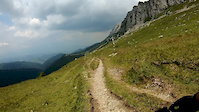
Long descent from Şaua Strunga, high in the Bucegi Mountains, to Şimon village. The upper part is scenic, going underneath the steeps of Strungile Mari and Grohotişului Mountains. The surface is rocky here, with some technical passages. As you get lower and enter the forest, the trail widens and becomes mellower. These sections are quite fast, with no major obstacles.

This trail is unsanctioned.

Recent Activity on Trail

Past Week
  • 0 rides
  •  
6 Months
  • 2 rides
  • 15 miles avg distance
All
  • 30 rides
  • Last: May 31, 2026
c1c2c3c4
January
February
March
April
May
June
July
August
September
October
November
December
update trails status or condition

Şaua Strunga -... Trail Reports

statusdatedescription
May 23, 2026 @ 12:30pm (Europe/Bucharest)
May 23, 2026
Aderenta bună, surprinzător de lipsit de noroi ținând cont de ploi. O limba de zăpadă intre șaua strunga și vf Bucsa.
Jul 2, 2025 @ 6:26am
Jul 2, 2025
Nov 2, 2024 @ 10:22am
Nov 2, 2024
Oct 26, 2024 @ 11:31am
Oct 26, 2024
Aug 18, 2024 @ 12:32pm
Aug 18, 2024
more »
Status:
on May 23, 2026
Variable
Avg: 4.29 (5 votes)
Your vote: 0

view (283)
close
3D
Trail Conditions
  • Unknown
  • Snow Groomed
  • Snow Packed
  • Snow Covered
  • Snow Cover Partial
  • Freeze/thaw Cycle
  • Icy
  • Prevalent Mud
  • Wet
  • Variable
  • Ideal
  • Dry
  • Very Dry
Trail Flow (Ridden Direction)
Trailforks scans users ridelogs to determine the most popular direction each trail is ridden. A good flowing trail network will have most trails flowing in a single direction according to their intension.
The colour categories are based on what percentage of riders are riding a trail in its intended direction.
  • > 96%
  • > 90%
  • > 80%
  • > 70%
  • > 50%
  • < 50%
  • bi-directional trail
  • no data
Trail Last Ridden
Trailforks scans ridelogs to determine the last time a trail was ridden.
  • < 2 days
  • < 1 week
  • < 2 weeks
  • < 1 month
  • < 6 months
  • > 6 months
Trail Ridden Direction
The intended direction a trail should be ridden.
  • Downhill Only
  • Downhill Primary
  • Both Directions
  • Uphill Primary
  • Uphill Only
  • One Direction
Contribute Details
Colors indicate trail is missing specified detail.
  • Description
  • Photos
  • Description & Photos
  • Videos
Trail Popularity ?
Trailforks scans ridelogs to determine which trails are ridden the most in the last 9 months. Trails are compared with nearby trails in the same city region with a possible 25 colour shades. Think of this as a heatmap, more rides = more kinetic energy = warmer colors.
  • most popular
  • popular
  • less popular
  • not popular
ATV/ORV/OHV Filter
Max Vehicle Width
inches
US Cell Coverage
Legend
cell carrier legend

Radar Time
Activity Recordings
Trailforks uses anonymized public activity data. ?
Activity Recordings
Trailforks uses anonymized public activity data. ?
Personal Heatmap
Activity Types
all / none
Options
2
Date range month
Winter Trails
Warning A routing network for winter maps does not exist. Selecting trails using the winter trails layer has been disabled.
Missing Trails
Most Popular
Least Popular
Trails are colored based on popularity. The more popular a trail is, the more red. Less popular trails trend towards green.
Jump Magnitude Heatmap
Heatmap of where riders jump on trails. Zoom in to see individual jumps, click circles to view jump details.
BC Backroad Status

Service Road Atlas is a free to use, community-driven service for viewing and creating reports on the numerous back-country service roads around B.C. and Alberta.

map legend
Slope Aspect
Direction the slope faces
Flat N NE E SE S SW W NW
Trails Deemphasized
Trails are shown in grey.
disable
Only show trails with no bike usage.
Enable
Suggested Layers
Based on selected activity type

    Save the current map location and zoom level as your default home location whenever this page is loaded.

    Save
        Directions to aua-strunga-gu-anu trailhead (45.390640, 25.408310)

        Photos

        4 more »
        34 |
        Jul 2, 2025 @ 6:26am
        Jul 2, 2025
        29 |
        Jul 2, 2025 @ 6:26am
        Jul 2, 2025
        36 |
        Jul 2, 2025 @ 6:26am
        Jul 2, 2025
        27 |
        Jul 2, 2025 @ 6:26am
        Jul 2, 2025

        Videos

        3 more »
        Strunga
        20:00 | 405 | Aug 31, 2020 , Moieciu
        MTB All mountain Bucegi 07.2015 Padina Șaua...
        7:00 | 486 | Feb 28, 2019 , Moieciu
        Saua Strunga trail in Bucegi Mountains (big...
        11:18 | 168 | Aug 5, 2019 , Moieciu

        Reviews / Comments

        No reviews yet, be the first to write a review or ask a question.
        Use trail reports to comment on trail conditions.


        We hope you've been enjoying Trailforks!

        Create a FREE account to view trail comments and much more.

        • #170573 - 1,698 views

        Frequently Asked Questions About Şaua Strunga - Guţanu

        Where is Şaua Strunga - Guţanu located?
        Şaua Strunga - Guţanu is located in Moieciu, Romania. It is part of the Moieciu trail network. The trailhead is located at coordinates 45.39064, 25.40831.
        How hard is Şaua Strunga - Guţanu?
        Şaua Strunga - Guţanu is rated as Red difficulty. The physical rating is Moderate. The average grade is 9.3%. The climb difficulty is rated Blue.
        What is the elevation gain for Şaua Strunga - Guţanu?
        The trail has 459 m of elevation descent. The elevation ranges from 1,443 m to 1,902 m.
        How long is Şaua Strunga - Guţanu?
        Şaua Strunga - Guţanu is 5.0 km long. The trail type is singletrack.

        Hit the Trail

        Open in App

        Get this trail on your phone instantly.
        open trail in app

        Download Trail

        Save to wishlist, Garmin & download.
        save the trail

        Find Related Routes

        Find routes and users activities that include this trail.
        find routes for this trail

        You must enter a description before submitting.