more stats
3,461 ft
Distance
312 ft
Climb
00:17:31
Avg time
312 ft
Altitude change
6,693 ft
Altitude min
7,005 ft
Altitude max
6,693 ft
Altitude start
7,005 ft
Altitude end
9%
Grade
-2.5%
Grade max
33.5%
Grade min
3,107 ft
Distance climb
121 ft
Distance down
230 ft
Distance flat
00:17:31
Avg time

Audra Culver Details

  • Activities
    • Mountain Bike
    • Hike
    • Trail Running
  • Riding Area
    Horsetooth Mountain
    Fort Collins, Colorado
  • Difficulty Rating
  • Voted Difficulty
    Blue (1 vote)
  • Local Popularity
    55 in Mountain Biking [+]
    • 90 in Trail Running
    • 95 in Hiking
  • Global Ranking
    #106593 in Mountain Biking [+]
    • #27337 in Trail Running
    • #13801 in Hiking
  • Trail Type
    Singletrack
  • Direction
    Both Directions
    Popular Direction Shown
  • Climb Difficulty
    Black Diamond
  • Physical Rating
    Hard
  • Trail Visibility
    Always easy to follow
  • Dogs Allowed
    Yes
  • TTFs on Trail
    Rock Face, Rock Garden

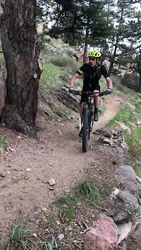
One of the lesser known hidden gems of Horsetooth Mountain Park, Audra Culver trail connects Southridge to Horsetooth Rock Trail. Though the signage for the section where this trail overlaps the Horsetooth Rock hiking-only trail is vague, be assured that bikes are allowed on all of this trail. Ridden uphill, this trail offers numerous steep pitches that are technically challenging with one particularly difficult obstacle near the end of the climb before the "squeeze" between two large rock features that marks the end of the climb, before a short descent back down to Southridge just above the top of Wathen. Ridden downhill, you'll first have to climb back up to the squeeze from the east-facing side which has an off-camber slab with some roots thrown in the mix, followed by a very steep slab that requires some momentum and 100% commitment to clean. From the high point back down to Southridge, the difficult obstacle to climb from the opposite direction is an easy roll, followed by moderately technical terrain back to the bottom. The trail is mostly decomposed granite (kitty litter) which can make traction challenging, but nothing you're not already used to if you've spent any time riding in the area.

Local Trail Association

Recent Activity on Trail

Past Week
  • 0 rides
  •  
6 Months
  • 2 rides
  • 14 miles avg distance
All
  • 42 rides
  • Last: Jun 14, 2026
c1c2c3c4
January
February
March
April
May
June
July
August
September
October
November
December
update trails status or condition

Audra Culver Trail Reports

statusdatedescription
Nov 2, 2024 @ 11:03am
Nov 2, 2024
Oct 28, 2022 @ 10:34am
Oct 28, 2022
Mar 14, 2022 @ 4:31am
Mar 14, 2022
Some dry sections between lots of ice and frozen mud. The chute at the top connecting to Horsetooth Rock trail was a skating rink on both sides,...
Nov 25, 2020 @ 5:58am
Nov 25, 2020
Nov 15, 2020 @ 11:58am
Nov 15, 2020
The beginning had a little hard pack snow, but otherwise good
more »
Status:
on Nov 2, 2024
Ideal
Avg: 3.86 (2 votes)
Your vote: 0

view (988)
close
3D
Trail Conditions
  • Unknown
  • Snow Groomed
  • Snow Packed
  • Snow Covered
  • Snow Cover Partial
  • Freeze/thaw Cycle
  • Icy
  • Prevalent Mud
  • Wet
  • Variable
  • Ideal
  • Dry
  • Very Dry
Trail Flow (Ridden Direction)
Trailforks scans users ridelogs to determine the most popular direction each trail is ridden. A good flowing trail network will have most trails flowing in a single direction according to their intension.
The colour categories are based on what percentage of riders are riding a trail in its intended direction.
  • > 96%
  • > 90%
  • > 80%
  • > 70%
  • > 50%
  • < 50%
  • bi-directional trail
  • no data
Trail Last Ridden
Trailforks scans ridelogs to determine the last time a trail was ridden.
  • < 2 days
  • < 1 week
  • < 2 weeks
  • < 1 month
  • < 6 months
  • > 6 months
Trail Ridden Direction
The intended direction a trail should be ridden.
  • Downhill Only
  • Downhill Primary
  • Both Directions
  • Uphill Primary
  • Uphill Only
  • One Direction
Contribute Details
Colors indicate trail is missing specified detail.
  • Description
  • Photos
  • Description & Photos
  • Videos
Trail Popularity ?
Trailforks scans ridelogs to determine which trails are ridden the most in the last 9 months. Trails are compared with nearby trails in the same city region with a possible 25 colour shades. Think of this as a heatmap, more rides = more kinetic energy = warmer colors.
  • most popular
  • popular
  • less popular
  • not popular
ATV/ORV/OHV Filter
Max Vehicle Width
inches
US Cell Coverage
Legend
cell carrier legend

Radar Time
Activity Recordings
Trailforks uses anonymized public activity data. ?
Activity Recordings
Trailforks uses anonymized public activity data. ?
Personal Heatmap
Activity Types
all / none
Options
2
Date range month
Winter Trails
Warning A routing network for winter maps does not exist. Selecting trails using the winter trails layer has been disabled.
Missing Trails
Most Popular
Least Popular
Trails are colored based on popularity. The more popular a trail is, the more red. Less popular trails trend towards green.
Jump Magnitude Heatmap
Heatmap of where riders jump on trails. Zoom in to see individual jumps, click circles to view jump details.
BC Backroad Status

Service Road Atlas is a free to use, community-driven service for viewing and creating reports on the numerous back-country service roads around B.C. and Alberta.

map legend
Slope Aspect
Direction the slope faces
Flat N NE E SE S SW W NW
Trails Deemphasized
Trails are shown in grey.
disable
Only show trails with no bike usage.
Enable
Suggested Layers
Based on selected activity type

    Save the current map location and zoom level as your default home location whenever this page is loaded.

    Save
        Directions to audra-culver trailhead (40.532940, -105.191440)

        Photos

        21 more »
        65 |
        Oct 20, 2022 @ 11:01am
        Oct 20, 2022
        41 |
        Oct 20, 2022 @ 11:00am
        Oct 20, 2022
        286 |
        Jan 24, 2015 @ 8:16am
        Jan 24, 2015
        317 |
        Jan 24, 2015 @ 8:17am
        Jan 24, 2015

        Videos

        1 more »
        Audra Culver Tech
        0:08 | 67 | Jan 25, 2023 , Fort Collins

        Trail Products

        Reviews / Comments

        No reviews yet, be the first to write a review or ask a question.
        Use trail reports to comment on trail conditions.


        We hope you've been enjoying Trailforks!

        Create a FREE account to view trail comments and much more.

        • By toddTF Pro Trailforks & contributors
        • #13580 - 2,304 views

        Frequently Asked Questions About Audra Culver

        Where is Audra Culver located?
        Audra Culver is located in Horsetooth Mountain, Fort Collins, Colorado, United States. It is part of the Horsetooth Mountain trail network. The trailhead is located at coordinates 40.53294, -105.19144.
        How hard is Audra Culver?
        Audra Culver is rated as Black Diamond difficulty. The physical rating is Hard. The average grade is 9%. The climb difficulty is rated Black Diamond.
        What is the elevation gain for Audra Culver?
        Audra Culver has 312 ft of elevation gain. The elevation ranges from 6,693 ft to 7,005 ft.
        Is Audra Culver a point to point trail?
        Audra Culver is not a point to point trail. The direction is Both Directions. The trail type is singletrack.

        Hit the Trail

        Open in App

        Get this trail on your phone instantly.
        open trail in app

        Download Trail

        Save to wishlist, Garmin & download.
        save the trail

        Find Related Routes

        Find routes and users activities that include this trail.
        find routes for this trail

        You must enter a description before submitting.