more stats
2,231 ft
Distance
-87 ft
Descent
00:02:21
Avg time
-87 ft
Altitude change
865 ft
Altitude min
952 ft
Altitude max
952 ft
Altitude start
866 ft
Altitude end
-3.9%
Grade
-11.3%
Grade max
-0.7%
Grade min
2,182 ft
Distance down
46 ft
Distance flat
00:02:21
Avg time

Aunt Flo Details

  • Activities
    • Mountain Bike
    • E-Bike
    • Winter Fat Bike
    • Hike
    • Trail Running
  • Riding Area
  • Difficulty Rating
  • Local Popularity
    75 in Mountain Biking [+]
    • 95 in E-Biking
    • 55 in Trail Running
    • 5 in Hiking
  • Global Ranking
    #54910 in Mountain Biking [+]
    • #87022 in Trail Running
    • #290746 in Hiking
  • Hiking SAC Scale
    T1 Hiking
  • Trail Type
    Singletrack
  • Snow Grooming
    Groomed Smooth
  • Bike Type
    DH, AM, XC, DJ, Fat
  • Direction
    Downhill Primary[+]
    Popular In Reverse
    • Downhill Primary for E-Biking
    • Both Directions for Trail Running
    • Both Directions for Hiking
    • Downhill Primary for Winter Fat Biking
  • Physical Rating
    Easy
  • Trail Visibility
    Always easy to follow
  • Dogs Allowed
    Yes
  • eBike Allowed
    Yes up to Class 1
  • TTFs on Trail
    Berm, Jump
  • Lighting
    No
  • Land Owner
    Private

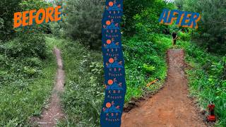
One of the top trails in the Maasto Hiihto-Churning Rapids trail system, Aunt Flo features jumps, rollers, and tabletops from top to bottom. No ridearounds on this one, so uphill travel can be a bit cumbersome. Best ridden downhill starting from the intersection with Spring Creek

Trail Supporters

Recent Activity on Trail

Past Week
  • 0 rides
  •  
6 Months
  • 5 rides
  • 15 miles avg distance
All
  • 127 rides
  • Last: Jun 13, 2026
c1c2c3c4
January
February
March
April
May
June
July
August
September
October
November
December
update trails status or condition

Aunt Flo Trail Reports

statusdatedescription
Jun 9, 2026 @ 9:25pm (America/Detroit)
Jun 9, 2026
May 26, 2026 @ 7:50pm (America/Detroit)
May 26, 2026
May 13, 2026 @ 3:30pm (America/Detroit)
May 13, 2026
At least a few large puddles on trail in addition to a handful of low hanging branches and some stick debris. There's also a tree down on the...
Aug 2, 2025 @ 3:38pm
Aug 2, 2025
Jun 19, 2025 @ 4:09am
Jun 19, 2025
more »
Status:
on Jun 9, 2026
Variable
Avg: 3.77 (3 votes)
Your vote: 0

view (663)
close
3D
Trail Conditions
  • Unknown
  • Snow Groomed
  • Snow Packed
  • Snow Covered
  • Snow Cover Partial
  • Freeze/thaw Cycle
  • Icy
  • Prevalent Mud
  • Wet
  • Variable
  • Ideal
  • Dry
  • Very Dry
Trail Flow (Ridden Direction)
Trailforks scans users ridelogs to determine the most popular direction each trail is ridden. A good flowing trail network will have most trails flowing in a single direction according to their intension.
The colour categories are based on what percentage of riders are riding a trail in its intended direction.
  • > 96%
  • > 90%
  • > 80%
  • > 70%
  • > 50%
  • < 50%
  • bi-directional trail
  • no data
Trail Last Ridden
Trailforks scans ridelogs to determine the last time a trail was ridden.
  • < 2 days
  • < 1 week
  • < 2 weeks
  • < 1 month
  • < 6 months
  • > 6 months
Trail Ridden Direction
The intended direction a trail should be ridden.
  • Downhill Only
  • Downhill Primary
  • Both Directions
  • Uphill Primary
  • Uphill Only
  • One Direction
Contribute Details
Colors indicate trail is missing specified detail.
  • Description
  • Photos
  • Description & Photos
  • Videos
Trail Popularity ?
Trailforks scans ridelogs to determine which trails are ridden the most in the last 9 months. Trails are compared with nearby trails in the same city region with a possible 25 colour shades. Think of this as a heatmap, more rides = more kinetic energy = warmer colors.
  • most popular
  • popular
  • less popular
  • not popular
ATV/ORV/OHV Filter
Max Vehicle Width
inches
US Cell Coverage
Legend
cell carrier legend

Radar Time
Activity Recordings
Trailforks uses anonymized public activity data. ?
Activity Recordings
Trailforks uses anonymized public activity data. ?
Personal Heatmap
Activity Types
all / none
Options
2
Date range month
Winter Trails
Warning A routing network for winter maps does not exist. Selecting trails using the winter trails layer has been disabled.
Missing Trails
Most Popular
Least Popular
Trails are colored based on popularity. The more popular a trail is, the more red. Less popular trails trend towards green.
Jump Magnitude Heatmap
Heatmap of where riders jump on trails. Zoom in to see individual jumps, click circles to view jump details.
BC Backroad Status

Service Road Atlas is a free to use, community-driven service for viewing and creating reports on the numerous back-country service roads around B.C. and Alberta.

map legend
Slope Aspect
Direction the slope faces
Flat N NE E SE S SW W NW
Trails Deemphasized
Trails are shown in grey.
disable
Only show trails with no bike usage.
Enable
Suggested Layers
Based on selected activity type

    Save the current map location and zoom level as your default home location whenever this page is loaded.

    Save
        Directions to aunt-flo trailhead (47.162970, -88.608880)

        Photos

        3 more »
        113 |
        Jun 15, 2021 @ 9:28am
        Jun 15, 2021
        215 |
        Mar 6, 2021 @ 5:49pm
        Mar 6, 2021
        149 |
        May 13, 2022 @ 12:38pm
        May 13, 2022

        Videos

        1 more »
        Trail Rebuild Ep. 1 | KBP RACING
        10:13 | 5 | Jun 18, 2026 , Hancock

        Routes with this trail

        5.0 20 miles 1,784 ft 30 Loop
        A longer loop around the Maasto Hiihto and Churning Rapids trail system, showcasing many of the highlights...
        5.0 27 miles 2,396 ft 35 Loop
        For those looking to experience just about everything that the Maasto Hiihto and Churning Rapids trail...

        Reviews / Comments

        No reviews yet, be the first to write a review or ask a question.
        Use trail reports to comment on trail conditions.


        We hope you've been enjoying Trailforks!

        Create a FREE account to view trail comments and much more.

        Frequently Asked Questions About Aunt Flo

        Where is Aunt Flo located?
        Aunt Flo is located in Maasto Hiihto - Churning Rapids, Hancock, Michigan, United States. It is part of the Maasto Hiihto - Churning Rapids trail network. The trailhead is located at coordinates 47.16297, -88.60888.
        How hard is Aunt Flo?
        Aunt Flo is rated as Blue difficulty. The physical rating is Easy. The average grade is 3.9%.
        What is the elevation gain for Aunt Flo?
        The trail has 87 ft of elevation descent. The elevation ranges from 865 ft to 952 ft.
        Is Aunt Flo a point to point trail?
        Aunt Flo is not a point to point trail. The direction is Downhill Primary. The trail type is singletrack.

        Hit the Trail

        Open in App

        Get this trail on your phone instantly.
        open trail in app

        Download Trail

        Save to wishlist, Garmin & download.
        save the trail

        Find Related Routes

        Find routes and users activities that include this trail.
        find routes for this trail

        You must enter a description before submitting.