

Open in App
Get this trail on your phone instantly.

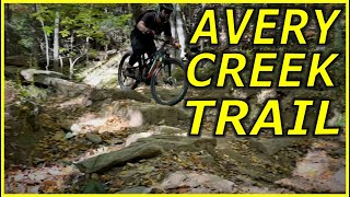
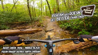
The newly reworked (Aug 2019) Avery Creek trail begins and ends at the same location as before, but has completely changed in character since Nature Trails, LLC rebuilt the trail. The new trail is wider, smoother, and less eroded than the previous version, with numerous alternative lines consisting of rock gardens, drops, jumps, and gaps. The previously eroded sections, which are common to Pisgah, have been widened, rock armored, and cleared up to prevent erosion. The new trail is faster, flowier, and smoother in most sections, but is different in character from other trails in Pisgah and requires a different approach to riding, particularly where jumps or rock features are involved.
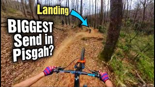
Riders not oriented with the trail should be cautioned to evaluate ALL features prior to dropping or jumping, as there are numerous gaps over drainage pools and some of them are not obvious until you are up on them. The largest feature is a 15-20ft long gap kicker near the middle of the trail, which jumps over a drainage ditch and lands in a berm. The remaining gaps are small rock kickers that are over small drains and are lower consequence, but less obvious.
The lower portion of the trail, after the initial creek crossing, turns flat and narrow. The lower portion has a number of creek crossings and/or log bridges leading up to a short, final climb back to Avery Creek Rd, but was not reworked and remains in the same character as the previous trail: largely flat with few technical sections of concern. The lower portion of the trail (after the intersection with Buckhorn Gap) runs along a river, with several swimming opportunities, and offers a more mellow ride aside from a few narrow sections of trail.
| c1 | c2 | c3 | c4 |
|---|---|---|---|
January | February | March | April |
May | June | July | August |
September | October | November | December |

Service Road Atlas is a free to use, community-driven service for viewing and creating reports on the numerous back-country service roads around B.C. and Alberta.
Save the current map location and zoom level as your default home location whenever this page is loaded.
SaveWe hope you've been enjoying Trailforks!
Create a FREE account to view trail comments and much more.
You must enter a description before submitting.

