more stats
1.5 miles
Distance
526 ft
Climb
-266 ft
Descent
00:15:05
Avg time
261 ft
Altitude change
516 ft
Altitude min
781 ft
Altitude max
518 ft
Altitude start
781 ft
Altitude end
3.2%
Grade
-54.1%
Grade max
142.5%
Grade min
3,284 ft
Distance climb
2,641 ft
Distance down
2,198 ft
Distance flat
00:15:05
Avg time

Axehead Details

  • Activities
    • Mountain Bike
    • E-Bike
  • Riding Area
    Blue Derby
    Derby
  • Difficulty Rating
  • Local Popularity
    95 in Mountain Biking [+]
    • 95 in E-Biking
  • Global Ranking
    #16441 in Mountain Biking [+]
    • #3827 in E-Biking
  • Trail Type
    Singletrack
  • Bike Type
    AM, XC
  • Climb Difficulty
    Green
  • Physical Rating
    Easy
  • Trail Visibility
    Always easy to follow
  • Family Friendly
    Yes
  • Dogs Allowed
    Yes
  • eBike Allowed
    Yes up to Class 1
  • TTFs on Trail
    Berm

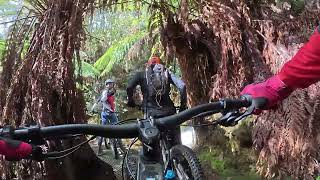
Axehead is the main access trail into the wider Derby trail network. Predominately an easy climbing trail, it features, views of the Cascade River, tree ferns and dense forests and passes by numerous old dry stone walls built by tin miners

Trail Supporters
Local Trail Association
Traditionally Indigenous Territory

Recent Activity on Trail

Past Week
  • 1 rides
  • 8 miles average
6 Months
  • 170 rides
  • 14 miles avg distance
All
  • 1,154 rides
  • Last: May 19, 2026
c1c2c3c4
January
February
March
April
May
June
July
August
September
October
November
December
Status:
on Apr 22, 2026
Ideal
Avg: 4.11 (12 votes)
Your vote: 0

view (8,850)
close
3D
Trail Conditions
  • Unknown
  • Snow Groomed
  • Snow Packed
  • Snow Covered
  • Snow Cover Partial
  • Freeze/thaw Cycle
  • Icy
  • Prevalent Mud
  • Wet
  • Variable
  • Ideal
  • Dry
  • Very Dry
Trail Flow (Ridden Direction)
Trailforks scans users ridelogs to determine the most popular direction each trail is ridden. A good flowing trail network will have most trails flowing in a single direction according to their intension.
The colour categories are based on what percentage of riders are riding a trail in its intended direction.
  • > 96%
  • > 90%
  • > 80%
  • > 70%
  • > 50%
  • < 50%
  • bi-directional trail
  • no data
Trail Last Ridden
Trailforks scans ridelogs to determine the last time a trail was ridden.
  • < 2 days
  • < 1 week
  • < 2 weeks
  • < 1 month
  • < 6 months
  • > 6 months
Trail Ridden Direction
The intended direction a trail should be ridden.
  • Downhill Only
  • Downhill Primary
  • Both Directions
  • Uphill Primary
  • Uphill Only
  • One Direction
Contribute Details
Colors indicate trail is missing specified detail.
  • Description
  • Photos
  • Description & Photos
  • Videos
Trail Popularity ?
Trailforks scans ridelogs to determine which trails are ridden the most in the last 9 months. Trails are compared with nearby trails in the same city region with a possible 25 colour shades. Think of this as a heatmap, more rides = more kinetic energy = warmer colors.
  • most popular
  • popular
  • less popular
  • not popular
ATV/ORV/OHV Filter
Max Vehicle Width
inches
US Cell Coverage
Legend
cell carrier legend

Radar Time
Activity Recordings
Trailforks uses anonymized public activity data. ?
Activity Recordings
Trailforks uses anonymized public activity data. ?
Personal Heatmap
Activity Types
all / none
Options
2
Date range month
Winter Trails
Warning A routing network for winter maps does not exist. Selecting trails using the winter trails layer has been disabled.
Missing Trails
Most Popular
Least Popular
Trails are colored based on popularity. The more popular a trail is, the more red. Less popular trails trend towards green.
Jump Magnitude Heatmap
Heatmap of where riders jump on trails. Zoom in to see individual jumps, click circles to view jump details.
BC Backroad Status

Service Road Atlas is a free to use, community-driven service for viewing and creating reports on the numerous back-country service roads around B.C. and Alberta.

map legend
Slope Aspect
Direction the slope faces
Flat N NE E SE S SW W NW
Trails Deemphasized
Trails are shown in grey.
disable
Only show trails with no bike usage.
Enable
Suggested Layers
Based on selected activity type

    Save the current map location and zoom level as your default home location whenever this page is loaded.

    Save
        Directions to axehead trailhead (-41.150760, 147.804380)

        Photos

        5 more »
        77 |
        Mar 3, 2023 @ 2:11pm
        Mar 3, 2023
        66 |
        Mar 3, 2023 @ 12:57am
        Mar 3, 2023
        152 |
        Jan 23, 2022 @ 11:13pm
        Jan 23, 2022
        250 |
        Dec 9, 2017 @ 3:34am
        Dec 9, 2017

        Videos

        4 more »
        Blue Derby Mountain Biking Trails - Axehead
        16:18 | 66 | Oct 11, 2025 , Derby
        Tas Derby Tasty Trout Falls
        0:02 | 479 | Mar 31, 2020 , Derby
        New Axehead Middle Section
        0:30 | 502 | Apr 3, 2018 , Derby
        Axehead
        739 | Feb 18, 2017 , Derby

        Routes with this trail

        8 miles 1,556 ft 4
        A great climb from the derby trail head up to the black stump then down back to town
        2.0 8 miles 1,357 ft 7 Loop
        Route 3 as planned by RideBlueDerby.com 3 offers an alternative to all the other recommended routes – it...
        11 miles 2,221 ft 6
        A great ride up to black stump then up through the tree ferns on to Kings Wall where you can expect some...

        Links

        1 Review & Comments


        We hope you've been enjoying Trailforks!

        Create a FREE account to view trail comments and much more.

        • By SchrodingersGatTF Pro MRTG & contributors
        • #34380 - 3,911 views

        Frequently Asked Questions About Axehead

        Where is Axehead located?
        Axehead is located in Blue Derby, Derby, Australia. It is part of the Blue Derby trail network. The trailhead is located at coordinates -41.15076, 147.80438.
        How hard is Axehead?
        Axehead is rated as Green difficulty. The physical rating is Easy. The average grade is 3.2%. The climb difficulty is rated Green.
        What is the elevation gain for Axehead?
        Axehead has 526 ft of elevation gain. The trail has 266 ft of elevation descent. The elevation ranges from 516 ft to 781 ft.
        How long is Axehead?
        Axehead is 1.5 miles long. The trail type is singletrack.

        Hit the Trail

        Open in App

        Get this trail on your phone instantly.
        open trail in app

        Download Trail

        Save to wishlist, Garmin & download.
        save the trail

        Find Related Routes

        Find routes and users activities that include this trail.
        find routes for this trail

        You must enter a description before submitting.