more stats
1.6 miles
Distance
57 ft
Climb
-96 ft
Descent
00:13:12
Avg time
-38 ft
Altitude change
4,362 ft
Altitude min
4,433 ft
Altitude max
4,433 ft
Altitude start
4,396 ft
Altitude end
-0.4%
Grade
-15.6%
Grade max
17.7%
Grade min
1,096 ft
Distance climb
2,238 ft
Distance down
1 mile
Distance flat
00:13:12
Avg time

AZ Cypress Details

  • Activities
    • Mountain Bike
    • Adaptive Bike
    • Horse
    • Hike
    • Trail Running
  • Riding Area
    Upper Dry Creek
    Sedona, Arizona
  • Difficulty Rating
  • Voted Difficulty
    Blue (2 votes)
  • Local Popularity
    60 in Mountain Biking [+]
    • 75 in Trail Running
    • 60 in Hiking
    • 5 in Horseback
  • Global Ranking
    #86962 in Mountain Biking [+]
    • #81959 in Trail Running
    • #89266 in Hiking
  • Hiking SAC Scale
    T1 Hiking
  • Trail Type
    Singletrack
  • Bike Type
  • Direction
    Both Directions
    Popular In Reverse
  • Physical Rating
    Moderate
  • Dogs Allowed
    Yes
  • eBike Allowed

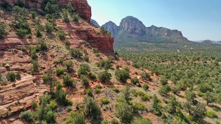
Beginner 80%, intermediate 20%, 1.64 mile MTB trail which is a bi-directional singletrack, that is routed along and across Dry Creek Wash four times. The trail tread is mostly routed on sand where it is close to the wash and on packed dirt with rocks on the section out of the wash that climbs to Girdner. There is no preferred direction and the trail is a great connector for several other fun loops. This is a multi-use trail, so beware of horses, hikers and trail runners.

Adaptive Bike Info
aMTB Blue Rating: Intermediate features and steeper terrain.

AVOID section from OK junction to Snake. Major obstacle. Rest of the trail is good. Some ledges and rocks at the exit to AZ Cypress Alt. aMTB's with FWD might need push.

Trail Supporters

  • USFS
    Land Manager
Local Trail Association

Recent Activity on Trail

Past Week
  • 0 rides
  •  
6 Months
  • 59 rides
  • 13 miles avg distance
All
  • 309 rides
  • Last: Jun 13, 2026
c1c2c3c4
January
February
March
April
May
June
July
August
September
October
November
December
Status:
on Mar 16, 2026
Ideal
Avg: 3.16 (12 votes)
Your vote: 0

view (1,380)
close
3D
Trail Conditions
  • Unknown
  • Snow Groomed
  • Snow Packed
  • Snow Covered
  • Snow Cover Partial
  • Freeze/thaw Cycle
  • Icy
  • Prevalent Mud
  • Wet
  • Variable
  • Ideal
  • Dry
  • Very Dry
Trail Flow (Ridden Direction)
Trailforks scans users ridelogs to determine the most popular direction each trail is ridden. A good flowing trail network will have most trails flowing in a single direction according to their intension.
The colour categories are based on what percentage of riders are riding a trail in its intended direction.
  • > 96%
  • > 90%
  • > 80%
  • > 70%
  • > 50%
  • < 50%
  • bi-directional trail
  • no data
Trail Last Ridden
Trailforks scans ridelogs to determine the last time a trail was ridden.
  • < 2 days
  • < 1 week
  • < 2 weeks
  • < 1 month
  • < 6 months
  • > 6 months
Trail Ridden Direction
The intended direction a trail should be ridden.
  • Downhill Only
  • Downhill Primary
  • Both Directions
  • Uphill Primary
  • Uphill Only
  • One Direction
Contribute Details
Colors indicate trail is missing specified detail.
  • Description
  • Photos
  • Description & Photos
  • Videos
Trail Popularity ?
Trailforks scans ridelogs to determine which trails are ridden the most in the last 9 months. Trails are compared with nearby trails in the same city region with a possible 25 colour shades. Think of this as a heatmap, more rides = more kinetic energy = warmer colors.
  • most popular
  • popular
  • less popular
  • not popular
ATV/ORV/OHV Filter
Max Vehicle Width
inches
US Cell Coverage
Legend
cell carrier legend

Radar Time
Activity Recordings
Trailforks uses anonymized public activity data. ?
Activity Recordings
Trailforks uses anonymized public activity data. ?
Personal Heatmap
Activity Types
all / none
Options
2
Date range month
Winter Trails
Warning A routing network for winter maps does not exist. Selecting trails using the winter trails layer has been disabled.
Missing Trails
Most Popular
Least Popular
Trails are colored based on popularity. The more popular a trail is, the more red. Less popular trails trend towards green.
Jump Magnitude Heatmap
Heatmap of where riders jump on trails. Zoom in to see individual jumps, click circles to view jump details.
BC Backroad Status

Service Road Atlas is a free to use, community-driven service for viewing and creating reports on the numerous back-country service roads around B.C. and Alberta.

map legend
Slope Aspect
Direction the slope faces
Flat N NE E SE S SW W NW
Trails Deemphasized
Trails are shown in grey.
disable
Only show trails with no bike usage.
Enable
Suggested Layers
Based on selected activity type

    Save the current map location and zoom level as your default home location whenever this page is loaded.

    Save
        Directions to az-cypress trailhead (34.893620, -111.831490)

        Photos

        7 more »
        78 |
        Aug 16, 2023 @ 9:06am
        Aug 16, 2023
        106 |
        May 10, 2021 @ 10:04am
        May 10, 2021
        102 |
        May 16, 2020 @ 3:44pm
        May 16, 2020
        102 |
        May 16, 2020 @ 3:44pm
        May 16, 2020

        Videos

        3 more »
        AZ Cypress UNCUT - Adaptive MTB - West Sedona,...
        6:13 | 266 | May 9, 2021 , Sedona
        Sedona MTB Festival 2020 - Day 2 | West Sedona...
        10:45 | 235 | Mar 16, 2020 , Sedona
        West Sedona - 2019/06/15
        8:10 | 225 | Dec 9, 2019 , Sedona

        Trail Lists

        Routes with this trail

        5.0 9 miles 826 ft 13 Loop
        An awesome loop that gives you a big bang for buck, intermediate and advanced riders will make quick work...
        3.5 9 miles 763 ft 4 Loop
        This route is mostly about highlighting Mescal. There route starts down a public dirt road in a public...
        3.2 12 miles 972 ft 21 Loop
        This is a fantastic cross country ride featuring three climbs, a few incredible descents, including the -...

        3 Reviews & Comments


        We hope you've been enjoying Trailforks!

        Create a FREE account to view trail comments and much more.

        Nearby Trails

        • By toddTF Pro Trailforks & contributors
        • #14683 - 3,946 views

        Frequently Asked Questions About AZ Cypress

        Where is AZ Cypress located?
        AZ Cypress is located in Upper Dry Creek, Sedona, Arizona, United States. It is part of the Upper Dry Creek trail network. The trailhead is located at coordinates 34.89362, -111.83149.
        How hard is AZ Cypress?
        AZ Cypress is rated as Green difficulty. The physical rating is Moderate. The average grade is 0.4%.
        What is the elevation gain for AZ Cypress?
        AZ Cypress has 57 ft of elevation gain. The trail has 96 ft of elevation descent. The elevation ranges from 4,362 ft to 4,433 ft.
        Is AZ Cypress a point to point trail?
        AZ Cypress is not a point to point trail. The direction is Both Directions. The trail type is singletrack.

        Hit the Trail

        Open in App

        Get this trail on your phone instantly.
        open trail in app

        Download Trail

        Save to wishlist, Garmin & download.
        save the trail

        Find Related Routes

        Find routes and users activities that include this trail.
        find routes for this trail

        You must enter a description before submitting.