more stats
4,548 ft
Distance
259 ft
Climb
-380 ft
Descent
00:07:20
Avg time
-121 ft
Altitude change
815 ft
Altitude min
987 ft
Altitude max
987 ft
Altitude start
865 ft
Altitude end
-59.983%
Grade max
39.695%
Grade min
1,654 ft
Distance climb
2,701 ft
Distance down
194 ft
Distance flat
00:07:20
Avg time

B-17 Trail Details

  • Activities
    • Mountain Bike
    • E-Bike
    • Hike
    • Trail Running
  • Riding Area
    Tamarancho
    Fairfax, California
  • Difficulty Rating
  • Voted Difficulty
    Blue (4 votes)
  • Local Popularity
    95 in Mountain Biking [+]
    • 80 in E-Biking
    • 60 in Trail Running
    • 65 in Hiking
  • Global Ranking
    #30858 in Mountain Biking [+]
    • #33025 in E-Biking
    • #82984 in Trail Running
    • #82096 in Hiking
  • Trail Type
    Singletrack
  • Bike Type
    XC
  • Direction
    Both Directions
    Popular Direction Shown
  • Climb Difficulty
    Blue
  • Physical Rating
    Moderate
  • Dogs Allowed
    Yes
  • eBike Allowed
  • Land Owner
    Boy Scouts of America

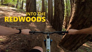
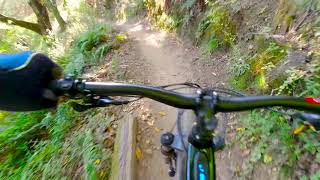
A Fun fast flowy trail that is made from classic redwood dirt. Trail named after the b17 crash on whites hill during the cold war.

Local Trail Association
Traditionally Indigenous Territory

Recent Activity on Trail

Past Week
  • 7 rides
  • 14 miles average
6 Months
  • 199 rides
  • 14 miles avg distance
All
  • 2,184 rides
  • Last: Jun 19, 2026
c1c2c3c4
January
February
March
April
May
June
July
August
September
October
November
December
Status:
on Apr 15, 2026
Variable
Avg: 4.15 (42 votes)
Your vote: 0

view (20,052)
close
3D
Trail Conditions
  • Unknown
  • Snow Groomed
  • Snow Packed
  • Snow Covered
  • Snow Cover Partial
  • Freeze/thaw Cycle
  • Icy
  • Prevalent Mud
  • Wet
  • Variable
  • Ideal
  • Dry
  • Very Dry
Trail Flow (Ridden Direction)
Trailforks scans users ridelogs to determine the most popular direction each trail is ridden. A good flowing trail network will have most trails flowing in a single direction according to their intension.
The colour categories are based on what percentage of riders are riding a trail in its intended direction.
  • > 96%
  • > 90%
  • > 80%
  • > 70%
  • > 50%
  • < 50%
  • bi-directional trail
  • no data
Trail Last Ridden
Trailforks scans ridelogs to determine the last time a trail was ridden.
  • < 2 days
  • < 1 week
  • < 2 weeks
  • < 1 month
  • < 6 months
  • > 6 months
Trail Ridden Direction
The intended direction a trail should be ridden.
  • Downhill Only
  • Downhill Primary
  • Both Directions
  • Uphill Primary
  • Uphill Only
  • One Direction
Contribute Details
Colors indicate trail is missing specified detail.
  • Description
  • Photos
  • Description & Photos
  • Videos
Trail Popularity ?
Trailforks scans ridelogs to determine which trails are ridden the most in the last 9 months. Trails are compared with nearby trails in the same city region with a possible 25 colour shades. Think of this as a heatmap, more rides = more kinetic energy = warmer colors.
  • most popular
  • popular
  • less popular
  • not popular
ATV/ORV/OHV Filter
Max Vehicle Width
inches
US Cell Coverage
Legend
cell carrier legend

Radar Time
Activity Recordings
Trailforks uses anonymized public activity data. ?
Activity Recordings
Trailforks uses anonymized public activity data. ?
Personal Heatmap
Activity Types
all / none
Options
2
Date range month
Winter Trails
Warning A routing network for winter maps does not exist. Selecting trails using the winter trails layer has been disabled.
Missing Trails
Most Popular
Least Popular
Trails are colored based on popularity. The more popular a trail is, the more red. Less popular trails trend towards green.
Jump Magnitude Heatmap
Heatmap of where riders jump on trails. Zoom in to see individual jumps, click circles to view jump details.
BC Backroad Status

Service Road Atlas is a free to use, community-driven service for viewing and creating reports on the numerous back-country service roads around B.C. and Alberta.

map legend
Slope Aspect
Direction the slope faces
Flat N NE E SE S SW W NW
Trails Deemphasized
Trails are shown in grey.
disable
Only show trails with no bike usage.
Enable
Suggested Layers
Based on selected activity type

    Save the current map location and zoom level as your default home location whenever this page is loaded.

    Save
        Directions to b17-trail trailhead (37.991020, -122.622450)

        Photos

        6 more »
        49 |
        May 15, 2025 @ 11:26pm
        May 15, 2025
        40 |
        May 15, 2025 @ 11:24pm
        May 15, 2025
        108 |
        Dec 31, 2022 @ 5:14pm
        Dec 31, 2022
        680 |
        Feb 16, 2015 @ 9:06pm
        Feb 16, 2015

        Videos

        6 more »
        youtuber Marinduro 2026! - Stage 3: B-17 & Broken Dam
        27:03 | 31 | May 10, 2026 , Fairfax
        Camp Tamarancho Loop, Fairfax, California
        6:00 | 217 | May 30, 2024 , Fairfax
        youtuber Tamarancho Trails - B-17
        13:27 | 383 | Apr 19, 2024 , Fairfax
        Camp Tamarancho Loop
        3:46 | 597 | Dec 6, 2020 , Fairfax

        Routes with this trail

        5.0 14 miles 2,406 ft 7
        Tamarancho Ride from Fairfax. Maiden Voyage
        3.5 7 miles 1,254 ft 10 Loop
        Great loop around Tamarancho Trail system!
        3.5 19 miles 2,965 ft 11 Loop
        Begin the Tamarancho loop via Alchemists Trail then take Dead Heifer Fire Road at the bottom of the Endor...

        Trail Products

        2 Reviews & Comments


        We hope you've been enjoying Trailforks!

        Create a FREE account to view trail comments and much more.

        • By TheBikeNerdTF Pro NWTA & contributors
        • #20431 - 8,909 views

        Frequently Asked Questions About B-17 Trail

        Where is B-17 Trail located?
        B-17 Trail is located in Tamarancho, Fairfax, California, United States. It is part of the Tamarancho trail network. The trailhead is located at coordinates 37.99102, -122.62245.
        How hard is B-17 Trail?
        B-17 Trail is rated as Blue difficulty. The physical rating is Moderate. The climb difficulty is rated Blue.
        What is the elevation gain for B-17 Trail?
        B-17 Trail has 259 ft of elevation gain. The trail has 380 ft of elevation descent. The elevation ranges from 815 ft to 987 ft.
        Is B-17 Trail a point to point trail?
        B-17 Trail is not a point to point trail. The direction is Both Directions. The trail type is singletrack.

        Hit the Trail

        Open in App

        Get this trail on your phone instantly.
        open trail in app

        Download Trail

        Save to wishlist, Garmin & download.
        save the trail

        Find Related Routes

        Find routes and users activities that include this trail.
        find routes for this trail

        You must enter a description before submitting.