more stats
3.5 miles
Distance
-3,392 ft
Descent
00:48:21
Avg time
-3,393 ft
Altitude change
1,798 ft
Altitude min
5,191 ft
Altitude max
5,191 ft
Altitude start
1,798 ft
Altitude end
-18.1%
Grade
-62.4%
Grade max
-2.9%
Grade min
4 miles
Distance down
00:48:21
Avg time

Backdoor Details

  • Activities
    • Mountain Bike
    • E-Bike
  • Riding Area
    Smithers
    , British Columbia
  • Difficulty Rating
  • Voted Difficulty
    Black Diamond (2 votes)
  • Local Popularity
    65 in Mountain Biking [+]
    • 45 in E-Biking
  • Global Ranking
    #73797 in Mountain Biking [+]
    • #94406 in E-Biking
  • Trail Type
    Singletrack
  • Bike Type
    DH, AM
  • Direction
    Downhill Only
    Popular Direction Shown
  • Physical Rating
    Hard
  • Dogs Allowed
    Yes
  • eBike Allowed
    Yes up to Class 1
  • TTFs on Trail
    Berm, Bridge, Drop, Jump, Gap Jump, Log Ride, Skinny, Teeter Totter, Wallride
  • Land Owner
    Hudson Bay Mountain Resort

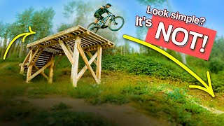
You could probably go as far as calling this trail an Epic. The trail begins with rocky/rooty terrain at a respectable grade, with some tricky tech moves over the roots in some areas. Things flatten out a bit around half way through, where you enter the mega-loam zone surrounded by green moss. We rode late September in the pouring rain, which I wouldn't recommend. Most of the wood has chicken wire, but everything else is very slippery. When you finish the trail, turn right instead of cutting through the farmers field. Recent trail updates make the trail a small bit longer than Trailforks indicates.

Access Info

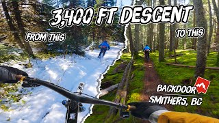
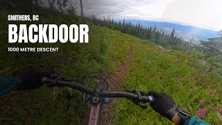
A short hike a bike up the ski run leads to a small plateau, with the trail dropping in riders right. There is a pretty well defined 4x4 track that will take you right to the trailhead.

Local Trail Association
Traditionally Indigenous Territory

Recent Activity on Trail

Past Week
  • 0 rides
  •  
6 Months
  • 0 rides
  •  
All
  • 53 rides
  • Last: Oct 6, 2025
c1c2c3c4
January
February
March
April
May
June
July
August
September
October
November
December
update trails status or condition

Backdoor Trail Reports

statusdatedescription
Dec 8, 2025 @ 10:38am (America/Vancouver)
Dec 8, 2025
Now closed for the season, see you all in 2026 👊🤠🤘
Jul 31, 2025 @ 11:51am
Jul 31, 2025
Jul 1, 2025 @ 4:57pm
Jul 1, 2025
Clear and Mint, top to bottom. What an epic track! :D \m/
Mar 27, 2025 @ 8:43pm
Mar 27, 2025
reporter
Sep 11, 2024 @ 2:21pm
Sep 11, 2024
more »
Status:
on Dec 8, 2025
Snow Covered
Avg: 4.39 (9 votes)
Your vote: 0

view (349)
close
3D
Trail Conditions
  • Unknown
  • Snow Groomed
  • Snow Packed
  • Snow Covered
  • Snow Cover Partial
  • Freeze/thaw Cycle
  • Icy
  • Prevalent Mud
  • Wet
  • Variable
  • Ideal
  • Dry
  • Very Dry
Trail Flow (Ridden Direction)
Trailforks scans users ridelogs to determine the most popular direction each trail is ridden. A good flowing trail network will have most trails flowing in a single direction according to their intension.
The colour categories are based on what percentage of riders are riding a trail in its intended direction.
  • > 96%
  • > 90%
  • > 80%
  • > 70%
  • > 50%
  • < 50%
  • bi-directional trail
  • no data
Trail Last Ridden
Trailforks scans ridelogs to determine the last time a trail was ridden.
  • < 2 days
  • < 1 week
  • < 2 weeks
  • < 1 month
  • < 6 months
  • > 6 months
Trail Ridden Direction
The intended direction a trail should be ridden.
  • Downhill Only
  • Downhill Primary
  • Both Directions
  • Uphill Primary
  • Uphill Only
  • One Direction
Contribute Details
Colors indicate trail is missing specified detail.
  • Description
  • Photos
  • Description & Photos
  • Videos
Trail Popularity ?
Trailforks scans ridelogs to determine which trails are ridden the most in the last 9 months. Trails are compared with nearby trails in the same city region with a possible 25 colour shades. Think of this as a heatmap, more rides = more kinetic energy = warmer colors.
  • most popular
  • popular
  • less popular
  • not popular
ATV/ORV/OHV Filter
Max Vehicle Width
inches
US Cell Coverage
Legend
cell carrier legend

Radar Time
Activity Recordings
Trailforks uses anonymized public activity data. ?
Activity Recordings
Trailforks uses anonymized public activity data. ?
Personal Heatmap
Activity Types
all / none
Options
2
Date range month
Winter Trails
Warning A routing network for winter maps does not exist. Selecting trails using the winter trails layer has been disabled.
Missing Trails
Most Popular
Least Popular
Trails are colored based on popularity. The more popular a trail is, the more red. Less popular trails trend towards green.
Jump Magnitude Heatmap
Heatmap of where riders jump on trails. Zoom in to see individual jumps, click circles to view jump details.
BC Backroad Status

Service Road Atlas is a free to use, community-driven service for viewing and creating reports on the numerous back-country service roads around B.C. and Alberta.

map legend
Slope Aspect
Direction the slope faces
Flat N NE E SE S SW W NW
Trails Deemphasized
Trails are shown in grey.
disable
Only show trails with no bike usage.
Enable
Suggested Layers
Based on selected activity type

    Save the current map location and zoom level as your default home location whenever this page is loaded.

    Save
        Directions to backdoor-3643 trailhead (54.772610, -127.262620)

        Photos

        23 more »
        491 |
        May 8, 2017 @ 12:57pm
        May 8, 2017
        595 |
        Sep 9, 2016 @ 6:38pm
        Sep 9, 2016
        544 |
        Sep 9, 2016 @ 6:35pm
        Sep 9, 2016
        510 |
        Sep 9, 2016 @ 6:33pm
        Sep 9, 2016

        Videos

        10 more »
        youtuber Sketching Out on Sketchy Features!
        10:53 | 394 | Sep 2, 2021 , Smithers
        youtuber Riding Northern BC | Backdoor Trail, Smithers
        10:15 | 1048 | Jul 5, 2019 , Smithers
        The Most EPIC MTB Trail you've NEVER Ridden:...
        21:13 | 57 | Mar 10, 2025 , Smithers
        Stunning 1000 metre alpine descent back to town
        20:31 | 79 | Jan 30, 2025 , Smithers

        4 Reviews & Comments


        We hope you've been enjoying Trailforks!

        Create a FREE account to view trail comments and much more.

        Nearby Trails

        Frequently Asked Questions About Backdoor

        Where is Backdoor located?
        Backdoor is located in Smithers, British Columbia, Canada. It is part of the Smithers trail network. The trailhead is located at coordinates 54.77261, -127.26262.
        How hard is Backdoor?
        Backdoor is rated as Black Diamond difficulty. The physical rating is Hard. The average grade is 18.1%.
        What is the elevation gain for Backdoor?
        The trail has 1,034 m of elevation descent. The elevation ranges from 548 m to 1,582 m.
        Is Backdoor a point to point trail?
        Yes, Backdoor is a point to point trail. The direction is Downhill Only. The trail type is singletrack.

        Hit the Trail

        Open in App

        Get this trail on your phone instantly.
        open trail in app

        Download Trail

        Save to wishlist, Garmin & download.
        save the trail

        Find Related Routes

        Find routes and users activities that include this trail.
        find routes for this trail

        You must enter a description before submitting.